
Tags
Last week we looked at creation and reception of the 1943 County of London Plan. It was a reminder of a time when democratic politics wasn’t viewed with contempt but was understood as a form of collective expression and – for some (for very many in the 1940s) – as a means of making a better world. That’s a language you hardly hear nowadays but maybe we should bring it back into fashion.
The language of JH Forshaw and Patrick Abercrombie in the Plan was generally more measured. The tone is bureaucratic, almost technocratic and their overall approach is flagged in their first chapter, ‘Social Groupings and Major Use Zones’. They saw the city as an agglomeration of zones with varying functions which had hitherto been inadequately separated or insensitively connected.

Coloured Plate 1: Social and Functional Analysis
In particular, they identified a ‘highly organised and inter-related system of communities as one of [London’s] main characteristics’. To strengthen and sustain these communities would be a major purpose of the County of London Plan:
The proposal is to emphasise the identity of the existing communities, to increase their degree of segregation, and where necessary to reorganise them as separate and definite entities. The aim would be to provide each community with its own schools, public buildings, shops, open spaces, etc.
The communities themselves ‘would be divided into smaller neighbourhood units of between 6,000 and 10,000 persons related to the elementary school and the area it serves’. Each of these units would possess or be provided with a neighbourhood centre and each would be surrounded by open space which would form ‘a natural cut-off between it and its neighbours’.

The neighbourhood unit would be an important trope of post-war planning but, whereas the Plan was clear that ‘community buildings, essential elements of the community’s structure, should be erected at the same time as the housing and not at a later date’, this would be less frequently achieved. It was, to a significant degree, in the Lansbury Estate in Poplar, completed in 1951 for the Festival of Britain and one of the few examples of the Plan’s direct influence. It was to a far lesser degree in the Mackworth Estate, Derby, though it was built very much according to the neighbourhood ideals that Abercrombie, in particular, sought to promote.

Coloured Plate 3: Open Space Plan

The world of the past: the only open space some London children knew before the war
To Forshaw and Abercrombie, ‘adequate open space for both recreation and rest [was] a vital factor in maintaining and improving the health of the people’. They calculated that four acres per 1000 of the population should suffice, taking into account the Green Belt around London first proposed in 1935. Lucky Woolwich already possessed six acres for each thousand of its population but the East End and ‘South Bank Boroughs’ were far less well served. While the planners had no anticipation of the collapse of the London docks that would occur in the 1960s, they envisaged too the river as a major local amenity.

Plate XXVI: The world of the past – a slum court

Plate XXVI, captioned ‘The Look In’ – a contrast to ‘The Outlook’ shown in the modern housing schemes below
Chapter Five of the Plan deals specifically with housing – the ‘provision of new housing’ would be ‘a most urgent task to be tackled after the war’. There were ‘extensive districts of the slum types [of housing]…in an advanced state of obsolescence due to hard use and age – conditions, of course, exacerbated by war damage: ‘these extreme conditions have made comprehensive schemes of redevelopment inescapable’.
The Plan set a relatively high figure of 136 persons per acre as its preferred housing density. Beyond this it was conservative in its proposals for rehousing – houses with gardens (or communal gardens) were judged preferable for families; terraced houses with appropriate provision of open space were suitable to central areas.

The world of the future: Plate XXVII – ‘Roehampton Cottage Estate’
It went on to state that a ‘certain number of high blocks up to ten storeys might prove popular, in particular for single people and childless couples’ but there was no anticipation here of the multi-storey solutions to mass housing that would mark public housing from the mid-1950s.

The world of the future: Plate XXVIII – White City Estate, Hammersmith, commenced 1936. Construction was suspended during the war. It was planned to contain 49 five-storey blocks, accommodating 11,000 people, when complete.
The caution perhaps reflected a more radical aspect of the Plan – the proposal that around 500,000 of London’s current population be rehoused outside the capital. The suggestion was welcomed by the London boroughs; in fact, Poplar and Stepney Borough Councils criticised the Plan for not going far enough. (1) (A reminder that back in 1910, Alfred Salter wanted ‘to pull down three quarters of Bermondsey and build a garden city in its place’; a proposal adopted more broadly and more cautiously by the London Labour Party as a whole in 1918.) The Plan proposed new developments on London’s fringes ‘located within the Metropolitan Traffic Area’ and, more significantly, ‘outer satellites’ on the fifty mile radius.
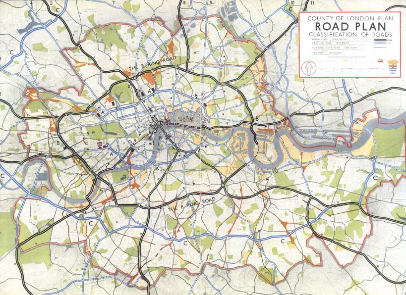
Coloured Plate 4: Road Plan
There is much else in the Plan – chapters on industry, communications, public services, architectural and environmental controls: too much to be covered here. But Chapter 7 on ‘Reconstruction Areas’ in some ways brings it all together. It took as its case study the East End, an obvious focal point of the various ‘present-day defects’ – traffic congestion, poor housing, ‘inadequate and maldistributed open space’, ‘indiscriminate mixed development’ and ‘lack of coherent architectural development’ – which the Plan had identified.
By contrast, reconstruction would separate local and through traffic and traffic and people, it would expand the provision of open space and greenery, it would separate industry, and it would build community through the neighbourhood units and civic centres noted above. The illustrations provided in the Plan of a redeveloped Shoreditch and Bethnal Green – the neighbourhood unit shown above and the axonometric view below – provide the best guide to the planning principles in place and future envisaged.

Axonometric view
Seventy years on, maybe the plans look a little too ‘rational’ and the reimagined East End seems rather sterile. But the cheery Cockneys we sometimes romanticise were living in slums and were voting for change. And if we’ve been taught to lament the loss of community that post-war rebuilding brought about, we should remember that for the Plan, at least, ‘community’ lay at the very heart of the new world it would create.
In the event, the sweeping changes that have occurred in London since 1945 have been far more ad hoc and owe as much to economic shifts in industry and employment as they do to any planner’s imagination. To many, this is a British virtue – a common-sense pragmatism eschewing theory and drawing board utopias. Most of us, if we’re honest, probably prefer the unplanned, rather messy London we have to the over-engineered and rather arid visions of technocrats. But the principle of planning – the notion that we can manage our environment to serve our community – should be sacrosanct and this was the great promise of the 1943 County of London Plan.
Concretely (a term that would seem unpleasantly literal to some), one result of the planning ideals pioneered in the London plan was the 1946 New Towns Act. Stevenage, the first new town, was a little closer than the 50 miles envisaged by Forshaw and Abercrombie but their influence is clear.

The world of the future: Broadwater neighbourhood centre, Stevenage
The other major legacy of the contemporary emphasis on planning was Labour’s 1947 Town and Country Planning Act which stipulated that all building schemes must first receive local authority approval and required councils to prepare comprehensive development plans. Such plans would not match the ambition of the London plan and others that emerged at this time from wartime destruction and peacetime aspiration. To some, they sometimes went too far. The wider legacy of planners and planning can be yours to judge.
I’ll conclude with an excerpt from the County of London Plan – an unremarkable aside at the time – which shows how far we have travelled and the future we have lost:
It is a commonplace to say that the war has done much to level incomes. There should be even less discrepancy afterwards, and this should be reflected in the Plan, which provides for a greater mingling of the different groups of London’s society. It is for this new world foreshadowed in the Atlantic Charter that the Capital of the Commonwealth must prepare itself.
Sources
(1) Mark Clapson, Peter J. Larkham, (eds), The Blitz and Its Legacy: Wartime Destruction to Post-war Reconstruction (2013)
All the quotations are drawn from JH Forshaw and Patrick Abercrombie, County of London Plan (1943)
Abercrombie was also the author of The Greater London Plan published in 1944. A documentary, The Proud City: a Plan for London was released in 1946.
The County of London Plan was one of a number produced during the Second World War. The most famous plan – also by Abercrombie and the one which was most fully implemented – is that for Plymouth. I have written about that in two posts:
A Plan for Plymouth: ‘our first great welfare state city‘ and A Plan for Plymouth: ‘Out of the disasters of war to snatch a victory for the city of the future‘.
Abercrombie partnered with Sir Edwin Luytens to write A Plan for the City and County of Kingston Upon Hull published in 1945. The City of Manchester Plan, published in 1945, is available online.

Pingback: The County of London Plan, 1943: ‘If only we will’ | Municipal Dreams
Pingback: Harlow New Town: ‘Too good to be true’? | Municipal Dreams
Reblogged this on The FeedBack and commented:
An interesting look at London’s past and what could have been its future…