Council housing, often hidden in plain sight, is arguably the greatest gift that architects have bequeathed London. Just as importantly, it has contributed immeasurably to not only the architectural, but also the social fabric of the capital.
You won’t be surprised to learn that I’m happy to endorse these words from Thaddeus Zupančič in his introduction to London Estates and I’m delighted that his new book provides such a superb photographic record of that contribution in the post-war years.
The photographs are, of course, the main course and you’ll see a representative sample on this page with supporting data from the book. But I’ll begin by commending the introduction – a succinct but detailed summary of the institutions, individuals and ideas that shaped council housing in the capital after 1945. Its breadth and precision are a testament to the expertise and zeal Thaddeus brings to this project as are the captions to the photographs listing the schemes’ architects and dates. It can be easy to glide over the latter but they’re the fruit of a lot of hard work and research where some detail can be surprisingly confused or murky.
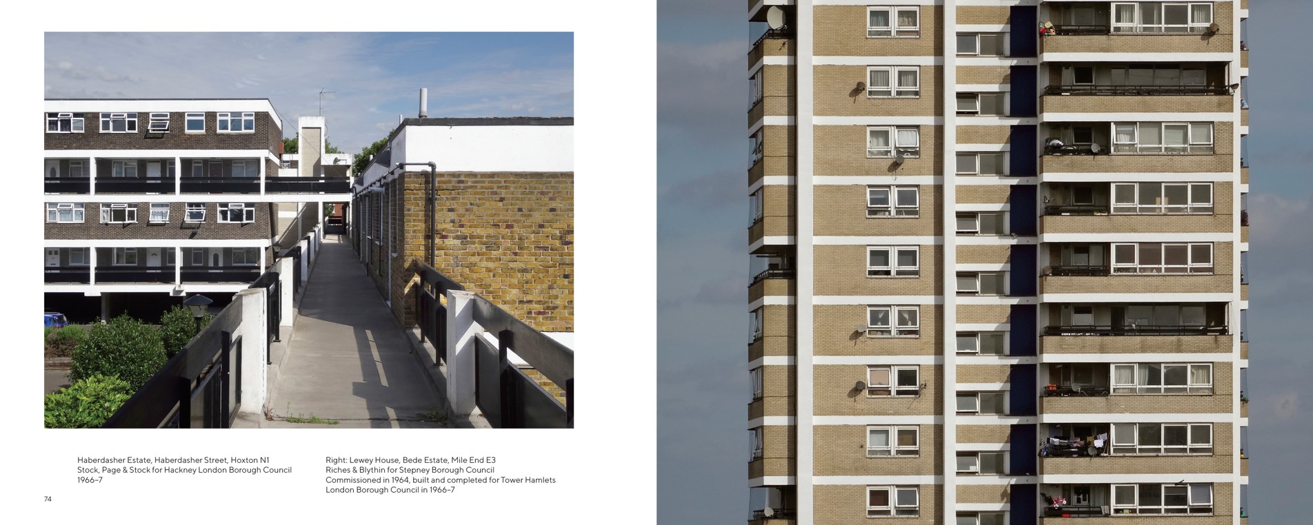
Pages 74-54, a good example of the layout and detail of the book
The photographs themselves are excellent – capturing the essence and sometimes the surprising detail of the 275 estates featured in a way that avoids the sterility of more self-conscious architectural photography. As someone who photographs council housing rather amateurishly, I know how tricky this is but, while Thaddeus observes the necessary conventions that keep people and traffic out of the picture, every photo seems a crystal clear evocation of its subject. Here the estates seem real, lived in, albeit with some of the rougher edges removed. Credit here too to FUEL, the publishers, for reproducing his colour photography in a restrained, realist palette.
The book is organised into four sections providing a geographical quadrant of the capital (North-East, North-West and so on). Within these, you’ll find estates and blocks from every London borough and the City. An index provides ready access to the individual schemes. Within those geographical segments, the illustrations follow a broadly chronological order that allows you to trace the architectural evolution of London’s council housing – from the interwar legacy designs of the early post-war period to the more daring modernism and off-the-peg high-rise of the later 1950s and 1960s, to the lower-rise modesty of the 1970s.
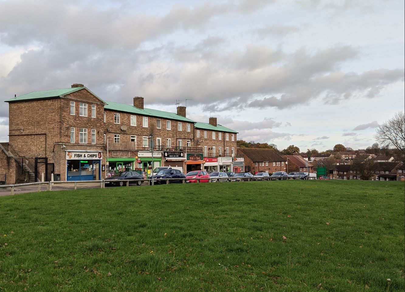
Becton Place, Erith; Erith Engineer and Surveyor’s Department; Borough Engineer and Surveyor John H Clayton; 1962
Some of the photographs depict the ‘iconic’ estates many of you will be familiar with but many cover lesser known schemes, some rather special, others architecturally quite ordinary – the full gamut: two-storey housing, slab blocks, point blocks, terraces, ziggurats, flats, maisonettes; all of them, above all, homes.
London Estates reminds us – contrary to the lazy stereotypes and easy generalisations of some commentators – of the range and variety of council homes in the capital and the thought and ingenuity that went into providing Londoners decent, secure and affordable homes. I don’t need to draw the contrast with the present.
Currently, despite a recent, small uptick in social housing construction, we are still – as a result of Right to Buy – suffering a net loss of social rent homes. The book includes some schemes (such as the Greater London Council’s Aintree Estate in Fulham and parts of Thamesmead) already demolished and others – Grange Farm built by the Borough of Harrow in 1969, to take one example – scheduled for demolition.
Cranbrook Estate, Bethnal Green; Skinner, Bailey & Lubetkin for Bethnal Green Metropolitan Borough Council; 1960-65
You’ll have your favourites – Churchill Gardens, Cranbrook Estate, Dawson’s Heights are among mine – but you’ll be introduced to quite unexpected schemes such as Queen Adelaide Court, designed by Edward Armstrong for Penge Urban District Council in 1951 when it won a Festival of Britain award. It’s invidious to select; you can explore for yourself and, if you’re local, maybe visit a few in person.
Lambrook House, Clifton Estate, Peckham; LCC Architect’s Department; built by the GLC Department of Architecture and Civic Design, 1967-79
I won’t indulge the reviewer’s habit of lamenting what the author has omitted. In 1981, there were 769,996 council homes in London, housing 31 percent of households in Greater London and 43 percent in inner London. I’m afraid – spoiler alert – not all of these are included in London Estates. But that, surely, is only an excuse for Thaddeus (who goes by the ironic monicker @notreallyobsessive on his popular Instagram account) and his publishers to produce a second volume in due course.
In the meantime, I’m very happy to recommend this book to anyone with an interest in council housing, its architecture and its evolution.
Thaddeus Zupančič is a Slovenian-born writer and translator who has lived in London since 1991. For the first 14 years, he worked as a radio producer with the BBC World Service. You might also be interested in reading Thaddeus’ post on London’s Modernist Maisonettes: ‘Going Upstairs to Bed’ published on this blog in March 2021.
Robin Hood Gardens, Poplar; Alison and Peter Smithson for the GLC; 1968-72; demolition begun 2017
I’m very pleased to feature a new post from Jill Stewart, the third of a three-part series. Jill is Associate Professor in Public Health at the University of Greenwich and has worked in housing for over 30 years. She has written previously for Municipal Dreams about the earliest environmental health practitioners before 1914 and after the First World War and on the South Oxhey Estate. This is my review of one of Jill’s books, Environmental Health and Housing: Issues for Public Health.
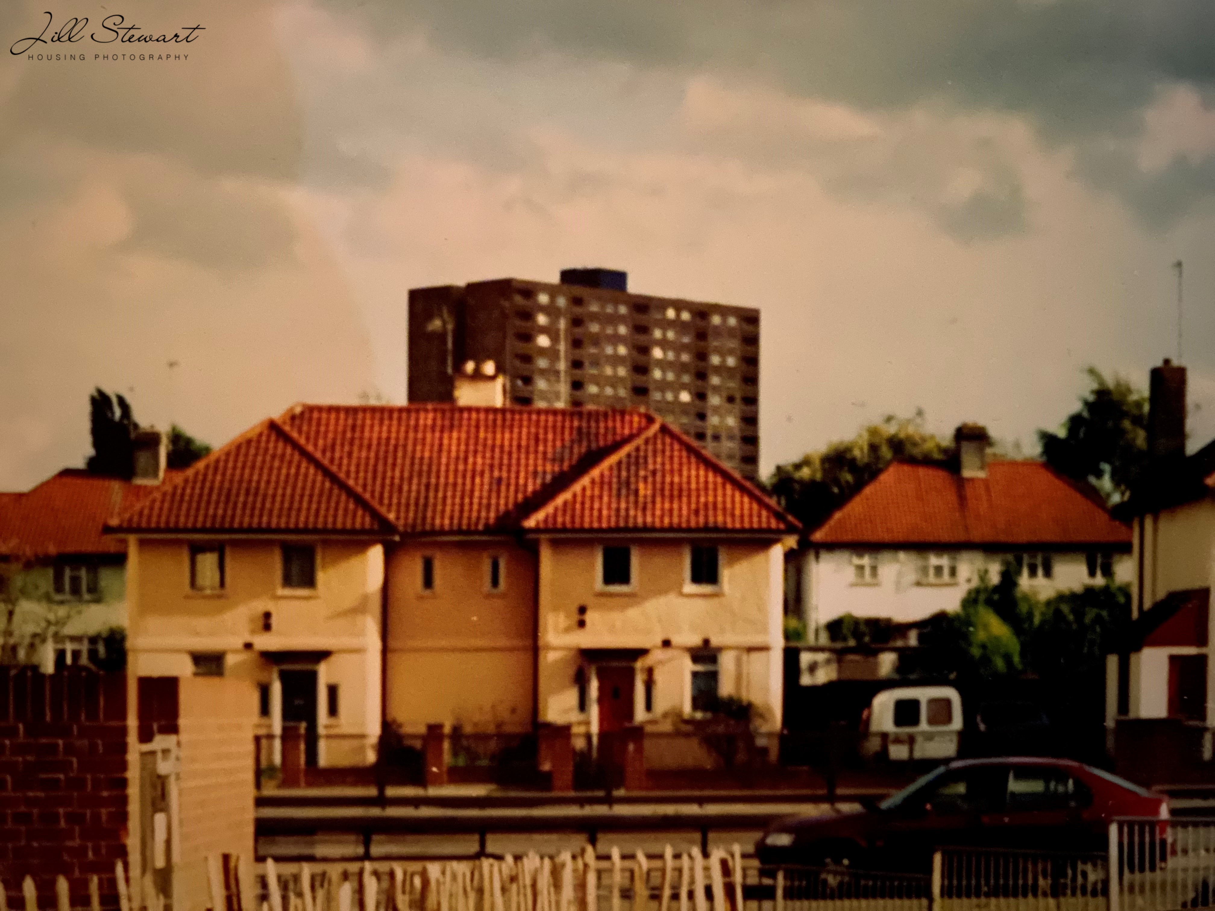
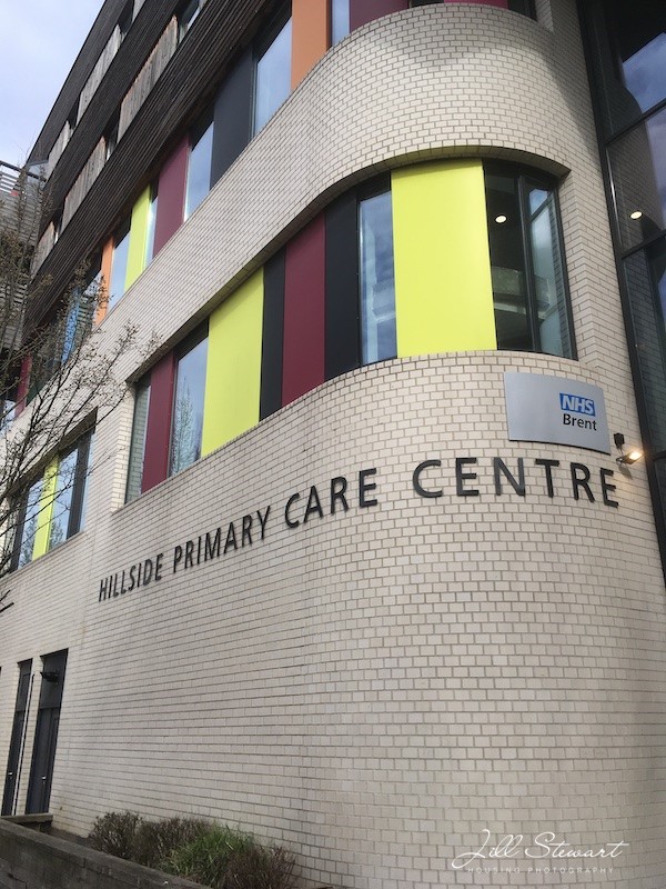
We finished last week with Stonebridge’s tower blocks and its community up until the 1980s. The question then was what would or could happen in estates like Stonebridge Park, where socio-economic conditions combined with poor housing conditions to create an area entrenched with seemingly so many issues it seemed hard to find any way forward at all?
In 1994 The Times Chronicle reported that Stonebridge was: (1)
a housing disaster … it is an estate filled with tall, graffiti-stained concrete blocks separated by patches of dirty lawn and straggly bushes. It has a high crime rate and a growing drug problem.
Stonebridge Park had more recorded crime than any other estate in Brent, with 142 allegations per 1000 people in 1992-1993, a third of these for burglary (2).
But many of the challenges faced went far beyond the local authority, the housing stock, its local environment and ‘design disadvantagement’ (3). Stonebridge Park had become a venue, a location, for many facing disadvantage and the complex combination of chronic social and economic problems and – perhaps worse – little hope that the situation of this once poor but strong community might re-emerge into somewhere both healthier and safer to live. Stonebridge was not alone in the major challenges it faced and by the 1980s the focus was increasingly around localised management, tenant consultation and stock transfer, and research was demonstrating the potential for substantial estate improvements in many areas (see for example, 4).
There are a range of images captured around this time showing us how Stonebridge looked then. Photographs of the tower blocks taken in 1988 (Figures 1 to 3) are available to see at Tower Block UK website – the two 13-storey blocks containing 270 dwellings (Mordaunt House and Longleats House), one nine-storey block containing 39 dwellings and six seven-storey blocks containing163 dwellings. (5)
There is also some news footage (6) and a short film about Stonebridge (7). The reggae musical film Babymother (8) was set in Stonebridge and Harlesden in 1998, with a cast of local people; it captures multiple scenes of the tower blocks at Stonebridge, now long gone, and it is worth watching for that alone.
Below are some photos I took around 2000 at Stonebridge Park. Perhaps a reader can help identify the names of the tower blocks in Figures 4-7?
Central government policy provided a new approach in the late 1980s in the form of Housing Action Trusts (HATs), part of a continued, wider ideological drive questioning the very role of local authorities as housing providers and managers. HATs were established to address the most challenging estates in the country and transfer to other landlords as part of a ‘privatising agenda’, since councils were not eligible for the substantial funding made available (9). Six Housing Action Trusts were established, one being Stonebridge, positioning it amongst the ‘worst’ estates in the country. This in itself demonstrates the major and complex challenges of the estate and that working toward solutions required strategies across multiple policy areas.
Stonebridge tenants voted in favour of a voluntary partnership HAT in 1991, encouraged by a major funding opportunity that would not otherwise be available. This was based on a cooperative model with rent levels and investment secured and an option to return to the local authority. Levels of voting were low but fulfilled the requirements for transfer (1, 10). The HAT was declared in 1994 with a range of funding. The HAT provided for tenants and health initiatives to be more pivotal in the regeneration process with partners. The Corporate Plan (1996-99) (11) (Fig 8) outlined the overall vision, achievements to date and future plans, including resident involvement, provision of good quality homes, improving youth and leisure facilities, improving housing management and increasing tenure choice.
This second complete redevelopment and regeneration was to be substantial. All the tower blocks are now gone, with a completely new living environment and opportunities available. The HAT ended in 2007 and the housing is largely split between Hillside Housing Trust (Hyde Group) and the London Borough of Brent. In 2008 the redevelopment received the European Urban and Regional Planning Award for public participation in housing (12).
There is still much reference to the ‘notorious run down 1960s Stonebridge Estate’ (13) but now with a more positive spin. Stonebridge has recently received numerous awards, including the Best Large Development at the National Housing Awards 2016. The judges said that this was:
A super example of regeneration with lots of benefit to the wider community. An architecturally varied and interesting scheme, particularly impressive is the intent of the landscape design. It has transformed one of London’s most challenging communities.
The development was shortlisted for the 2017 Housing Design Awards, 2017 Building Awards ‘Housing Project of the Year’, 24 Housing Awards 2018 ‘Affordable Housing Scheme of the Year’ and awarded a commendation in the 2019 Civic Trust Awards (14).
Visiting Stonebridge Park today, it certainly looks very different; in fact parts are entirely unrecognisable. Although there remain no hints of its tower block past, there are hints of its Victorian past and some of the terraces remain as does the entire Brentfield area. A very different vista awaits with a range of building styles and green spaces. Many of the pubs are gone – the Coach and Horses, the Orange Tree – but street names still hint at a dynamic past, including Mandela Close and Windrush Road. At the time of writing, the Altamira (see my first post on Stonebridge Park, Fig 4), once a showcase Victorian villa, is fenced off, presumably awaiting demolition.
But what has this meant for the health of those who now live there? The Joint Strategic Needs Assessment (JSNA) – in a sense the modern equivalent of the Medical Officer of Health’s (MoH) Report – indicates that the most highly deprived parts of Brent Council are in Stonebridge and Harlesden (15, 16). Brent has one Lower Layer Super Output Area (LSOA) that is within the 5 percent most deprived in England, in the area from Hillside to Milton Avenue in Stonebridge (readers might like to name check the roads from the 1933 MoH report in my first Stonebridge Park post, Fig 10). Some of the main problems are associated with barriers to physical and financial access to housing, including affordability.
Brent Council’s website reports that new council homes (and mixed tenure) and retail premises will be constructed on Milton and Hillside, along with retail space and new public open space (17) Regeneration is of course a long term strategy to bring about sustainable change to an areas and things are feeling much better for Stonebridge now. The range of photographs below perhaps best demonstrate Stonebridge Park as it now looks, with its new housing and health venues. The area also boasts the astonishing Shri Swaminarayan Mandir (Fig 10), completed 1995, literally positioned along Conduit Way, where our story of Stonebridge Park’s council housing started at the Brentfield estate.
I’m very pleased to feature a new post from Jill Stewart, the first of a three-part series. Jill is Associate Professor in Public Health at the University of Greenwich and has worked in housing for over 30 years. She has written previously for Municipal Dreams about the earliest environmental health practitioners before 1914 and after the First World War and on the South Oxhey Estate. This is my review of one of Jill’s books, Environmental Health and Housing: Issues for Public Health.
Visiting Stonebridge Park, NW10, today, in the urban London Borough of Brent, it’s hard to imagine that its first council housing was planned on an old sewage works on open space that the North Circular Road now cuts through (see figure 1 from 1908). Some will know Stonebridge Park as being near Wembley and Harlesden, or as the area between the popular Ace Café and the astonishing Neasden Temple. Others may know it from the news and reported levels of crime. But for many, it was the place they called home for many years in a close-knit community of families and friends, each a part of its dynamic history, experiencing a range of housing conditions and tenures over a century that we are looking at in this post.
Figure 1: Board of Guardians Map of Willesden Urban District, by O Claude Robson, 1908. With permission of London Metropolitan Archives, City of London. Document reference London Metropolitan Archives, City of London, BG/W/133
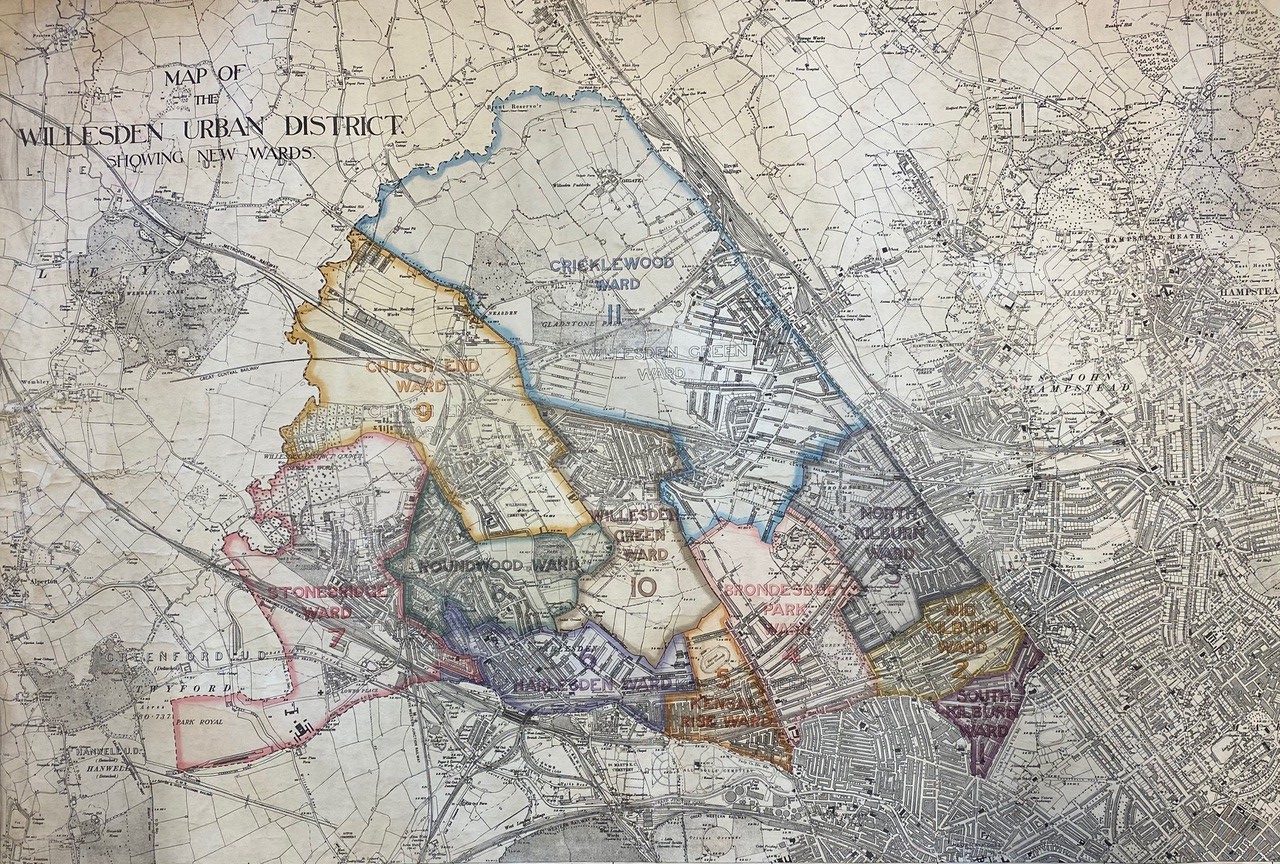
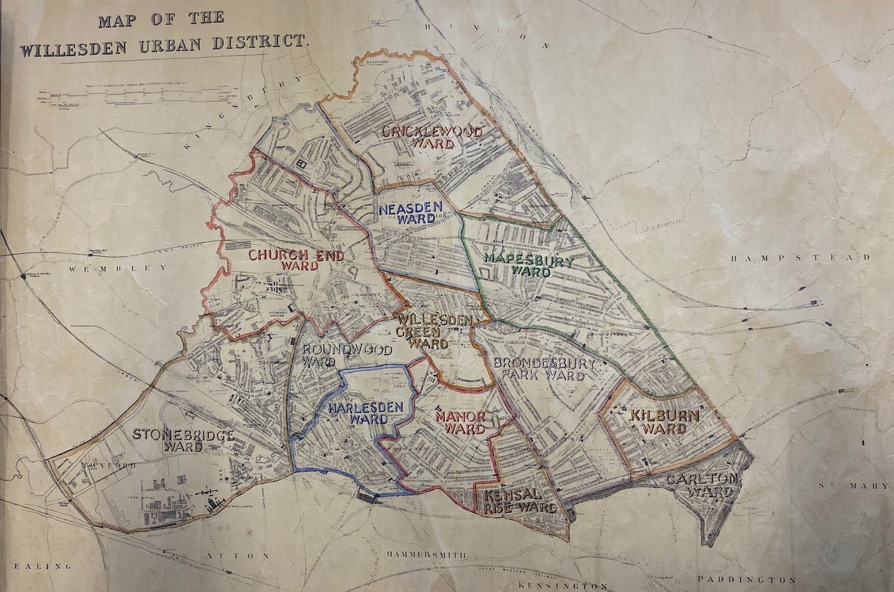
Situated near Wembley and sandwiched between Stonebridge Park and Harlesden stations, Stonebridge Park is spread across each side of the Harrow Road and Hillside. Some refer to it as Harlesden, but it is not. Once part of Middlesex County in the largely Labour controlled Willesden Borough (fig 2), Stonebridge came to comprise one of the then newly formed London Borough of Brent’s largest council housing estates, along with South Kilburn and Chalkhill, the latter in the then Borough of Wembley (1).
Fig 2: Map of Willesden Urban District, showing the Brentfield estate, undated but probably 1920s by F. Wilkinson, Borough Engineer (note he also authored the document included in reference 6 below). With permission of London Metropolitan Archives, City of London. Document reference London Metropolitan Archives, City of London, BG/W/136.
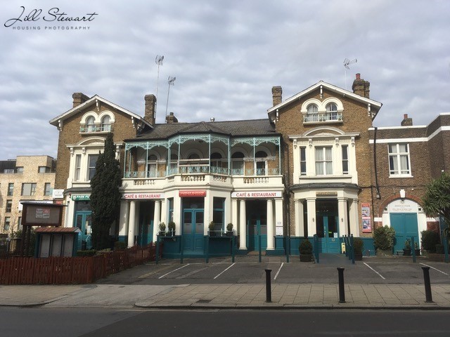
What is surprising now for those who know this busy urban setting is that in the late 19th century plans for the area were for it to be a setting for large villas. Indeed, some of these properties remain as reminders and a nod to this past and journey that Stonebridge Park may otherwise have taken. But that was not to be. All that remains now of these large properties is the Stonebridge Park Hotel (now The Bridge) along Hillside (Fig 3) and the Italianate inspired villa Altamira 1876 (Fig 2) that at the time of writing (spring/summer 2023) looks set for demolition (2). These heritage features added – and continue to add importance – aspects of identity to the area and many are sad to see them under threat.
Any history of housing is also a history of health, perhaps most explicitly when council housing is involved. This post develops the earlier Municipal Dreams posts of Tackling the Slums 1848-1914 and 1914-1939, but here we focus on Stonebridge Park’s council housing from just after the First World War to the present day. The Medical Officers of Health, then in local councils, worked closely with Sanitary Inspectors, later called Public Health Inspectors (now known as Environmental Health Officers or Practitioners) to address poor housing conditions. The links between housing and health were well established into council house building by the Housing and Planning Act 1919 (also known as the Addison Act), Dr Christopher Addison being the first Minister of Health and Housing.
I am going to try to tell Stonebridge Park’s unique history using archives, personal knowledge, photographs and films. There are really three phases in the history of Stonebridge Park’s council housing. First, a slightly delayed effort at Homes for Heroes (properly termed ‘a land fit for heroes to live in’) after the First World War. Next, a lag after the Second World War and into the world of substantial clearance and redevelopment and new tower blocks. Next, a new and more recent approach delivered by a Housing Action Trust and beyond that, to the Stonebridge Park that exists today. Whilst this is a local history, it will have resonance to many interested in housing history more widely.
A land fit for heroes to live in
Plans had already been afoot in 1914 to house Willesden’s working classes but there were delays and then the onset of War. They were held in abeyance until the Housing and Planning Act 1919 (the Addison Act). In 1917 the Local Government Board requested that Willesden make land available for housing and council owned land at Stonebridge was selected, using the ancient name of Brentfield. Plans were submitted to the Minister for Health in January 1919 but amended in June 1919 due to plans for the North Circular Road. Following various delays and new proposals between the Ministry and Housing Committee of the Council, plans were finally adopted in January and contracts for building signed in May 1920 (3, 4, 5, 6). See Figs 3 and 4.
Fig 5: Willesden Urban District Council Brentfield Housing Scheme Booklet, June 1921, front cover. Reproduced by kind permission of Brent Museum and Archives (Reference 6).Fig 6: Willesden Urban District Council Brentfield Housing Scheme Booklet, June 1921, parlour house designs. Reproduced by kind permission of Brent Museum and Archives (Reference 6)
The Opening Ceremony was reported in the Willesden Chronicle (5) attended by Council representatives, new families in residence and children singing and enjoying the event. Speeches referred to families having a ‘home and the centre of family life … a fair chance … free from the interference of other people’ and mentioned that ‘all tenants had their own drying ground and their own copper’. The article added: ‘the people of Willesden would feel that they had something on this historic spot that had been worth creating and worth preserving’.
These Addison houses were part of the drive for a land fit for heroes to live in after the war. The report tells us about the new housing but not what it must have meant for those who were to be housed there. Many residents in the then Borough of Willesden, in places including Kensal Green, had endured some really poor and overcrowded accommodation over a substantial period of time. For one family who were to later move to the Brentfield estate, poor housing conditions in other parts of Willesden were at least in part responsible for the loss of six of their children to disease including premature birth, debility and bronchitis.
It was cases like this that had kept the Medical Officer of Health for Willesden (MoH) very busy and much can be gleaned from their annual reports about housing and health. In the 1919 report, the MoH wrote that the staff engaged with housing work in the Health Department included one Chief Sanitary Inspector and six District Sanitary Inspectors and one Clerk, who had issued orders for repairs, voluntary closures and closing orders in the general Willesden area (7).
The municipal Stonebridge Health Centre, on the Harrow Road, was opened on 8th April 1930 by the Rt. Hon. Arthur Greenwood and was described as one of the few centres nationally to be specifically designed, built and equipped for modern health work, with a focus on maternity, child welfare and school medical work. It also offered an Artificial Sunlight Clinic and Orthopaedic Clinic (8). Arthur Greenwood had served as Labour’s Parliamentary Secretary to the Ministry of Health in 1924 and was appointed Minister of Health in 1929, later becoming Deputy Prime Minister under Clement Attlee.
Even by 1933, Willesden’s MoH (10) had singled out several roads in Stonebridge (and nearby Kensal Green) as requiring intervention. These comprised some 1036 properties housing 9297 persons: Carlyle Avenue, Milton Avenue, Shakespeare Road, Shelley Road, Shrewsbury Road, Melville Road, Winchelsea Road, Mordaunt Road, Wesley Road, Brett Road, Barry Road, Denton Road (see 10) and Hillside from Shrewsbury Road to Denton Road. The report went on say: ‘It is not easy to give an estimate of the amount of overcrowding in these areas but it is not inconsiderable, and houses would be required to be provided for persons displaced from such areas.’ (Please remember these addresses; we will come back to some of them in the 1970s, but the point to emphasise now is the immense amount of time households lived in known poor and overcrowded conditions, around 40 more years.)
It is not quite clear what happened during the 1930s but as the world moved toward war, housing at Stonebridge seemed to be on the back burner, despite the immense challenges faced.
Post-World War Two in the Borough of Willesden: housing loss and renewed progress
Both the MoH wartime and post-war reports reveal the extent to which Stonebridge suffered bombing during the Second World War (11). In 1944 the MoH referred to the ‘renewal of hostile activity and the re-evacuation of residents and their families from the area’ and the damage to the Willesden Green and Stonebridge Health Centres. Being next to Harlesden, Park Royal and so many factories including Heinz and McVities, Stonebridge Park endured substantial bombing and V2 raids. The 1948 MoH report (12) reveals that 92 homes were destroyed by bombing in Stonebridge Park, some locations are shown on the Bomb Sight map below.
The MoH report for 1949 continued to emphasise the effects of the war and poor housing conditions on the population, with ‘mixed populations with bad, almost slum property in Church End and Stonebridge …’ (13, p.6). The 1950 report (14) focused on tuberculosis, recognising the environmental conditions and overcrowding in places like Stonebridge contributing to the highest levels in the borough. By 1951 the MoH said: ‘Since the treatment of tuberculosis is very costly, not only in medical treatment but also in production and in lives, it is much more economical in the long run to spend the money on improving housing and nutrition and thus preventing the disease’ (15, p.13). As people continued to move into the area in the early 1950s, the MoH (16) reported increased overcrowding and home accidents amongst lower income households and called for better housing to conquer tuberculosis.
With the war having diverted attention from housing interventions and renewal, existing housing falling into greater disrepair and overcrowding due to the scarcity of building supplies and builders, conditions had deteriorated further. Bernard Shaw House was built around 1951 (Fig 11) but housing need remained acute. But it wasn’t just housing policy that was changing, there were far wider socio-economic challenges on the horizon. Industry was in decline and unemployment on the increase, youth culture was in ascendance, and tensions in race relations provided an emerging backdrop to what was to happen next.
(1) Stewart, J. and Rhoden, M. (2003) ‘A review of social housing regeneration in the London Borough of Brent’, The Journal of The Royal Society for the Promotion of Health, 123 (1), pp.23-32
Here’s a quick and simple guide to some of the more interesting housing schemes – for me, those are principally public housing projects and others of broadly progressive intent – featured in this year’s Open House London which runs between 8 and 21 September with most events taking place on the weekend of the 17th and 18th.
The entries are listed in roughly chronological order. The highlighted links in bold show Open House descriptions; earlier relevant blog posts are shown in bold and italics. Open House’s tagging is somewhat inconsistent. I’ve ranged across the categories but you can let me know if I’ve missed anything.
The Bedford Park estate in Chiswick, privately developed from 1875 and featuring housing by Norman Shaw and other leading architects of the day, is considered Britain’s first garden suburb, a prototype for much that was to follow though more often in attenuated form.
North View, Brentham Gardens
Brentham Garden Suburb is significant as a co-partnership scheme intended by Ealing Tenants Ltd to cater for at least the more affluent of the working class. From 1907, Raymond Unwin and Barry Parker, emerging as the two of the country’s leading architects and planners, developed the estate along garden suburb and arts and crafts lines.
Roe Green Village (Brent) was designed by Frank Baines in 1916, chief architect of the Office of Works, as housing for workers engaged in First World War armaments production. He had earlier designed the exemplary Well Hall Estate in Eltham for the same purpose. It offered a model for the ‘Homes for Heroes’ that were promoted at war’s end.
Barville House, Honor Oak Estate
The Honor Oak Estate in Lewisham, built by the London County Council (LCC) in the 1930s, was a very different animal comprising the typical four/five-storey, walk-up, balcony access tenement blocks intended to provide higher density housing for the inner-city working class. Early criticisms of the estate’s design saw it described as a ‘warning for planners’ in 1945.
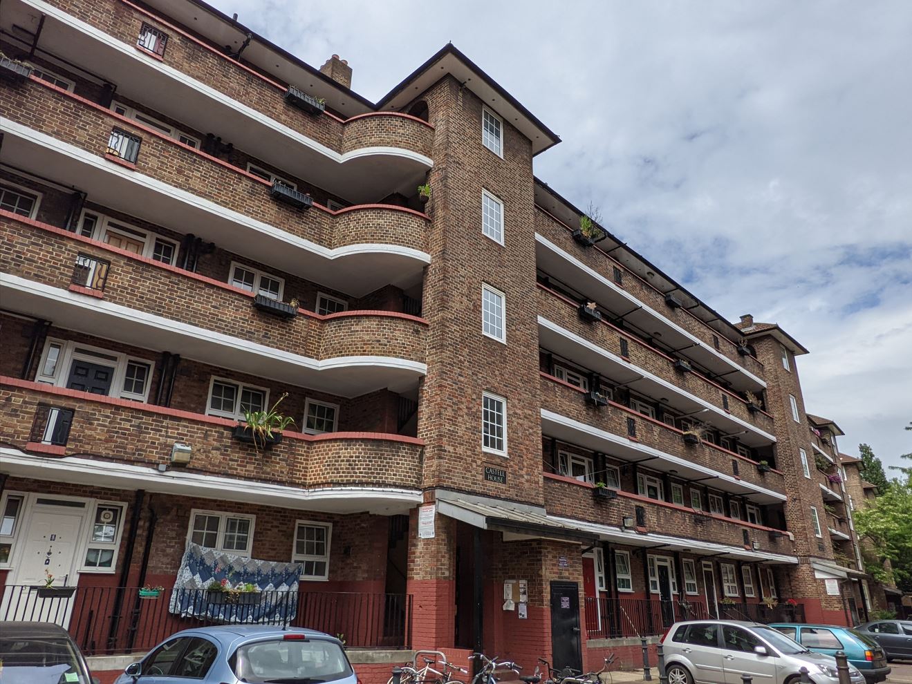
Castell House, Crossfield Estate
The Crossfield Estate, further north in Deptford, is another London County Council Estate of the same era and form. Transferred in poor condition to Lewisham Borough Council in 1971, a visit will also cover the estate’s later, more bohemian history.
Great Arthur House, Golden Lane Estate
The high ambitions of the best of post-Second World War council housing are illustrated in the Golden Lane Estate, designed by Chamberlin, Powell and Bon (also responsible for the Barbican scheme) for the City of London. The visit here focuses principally on sometimes controversial more recent renovation. Crescent House, a later completed section of the estate strongly influenced by Le Corbusier, features separately.
Crescent House, Golden Lane Estate
The Vanbrugh Park Estate was another Chamberlin, Powell and Bon scheme designed for Greenwich Metropolitan Borough Council in the later 1950s – a more modest scheme of 64 flats, low-rise terraced houses, and maisonettes planned to respect its surrounds and promote community.
Bevin Court staircase
The ambition of Finsbury Metropolitan Borough Council was obvious in the commissioning of Berthold Lubetkin to design Bevin Court, opened in 1954. Visit to see its crowning glory central staircase and the recently restored Peter Yates murals and bust of Bevin in the entrance lobby.
Alton West slab blocks
Meanwhile, the architects of the LCC were designing in Roehampton, west London, what an American commentator described as ‘the best low-cost housing in the world’. Alton East, from 1952, was designed by the New Humanists of the department who took the ‘softer’ lines and appearance of Scandinavian social housing as their principal model; Alton West, from 1954, was designed by those who favoured the ‘harder’, more monumental Brutalist style of Le Corbusier. The visit focuses on the landscaping that was a crucial component of the ensemble.
Keeling House
The self-guided walking tour of Bethnal Green takes in a variety of venues and sights including Denys Lasdun’s Keeling House cluster-block tower designed for Bethnal Green Metropolitan Borough Council opened in 1959.
Eddystone Tower, Pepys Estate
Back to the LCC which began planning the Pepys Estate in Lewisham in the early 1960s. In the event, this showpiece estate was completed by the Greater London Council (GLC) that took over in 1965. The 78 metre, 26-storey Eddystone Tower is one of the three original tower blocks of the scheme and the visit provides fine views from its top floor. Arguably better views are offered by Aragon Tower, nearer the river, but that was sold to Berkeley Homes for £11.5m in 2002. This is your regular reminder that regeneration schemes promoted by local authorities and housing associations in partnership with private developers invariably lead to a net loss of social rent house, however self-promotingly sold.
Coralline Walk, Thamesmead, prior to its recent demolition
Thamesmead, conceived as a new town of some 60,000 population to the east of London by the GLC in 1966, never lived up to its early hype but some fine and daring architecture was created in the process – much of it, sadly, now being demolished. Two walking tours – Thamesmead: Beyond Brutalism and Town of Tomorrow: Thamesmead Through Film – capture some of this as well as the area’s later growth and reinvention.
Ethelburga Tower in Battersea was another LCC scheme completed by the GLC in 1967, part of the Ethelburga Estate which comprised 578 homes in a range of otherwise medium- and low-rise blocks. Architect designed and of in situ reinforced concrete construction, it pre-dates the fashion for off-the-peg and system-built schemes that would soon become significant in the post-1965 Borough of Wandsworth as elsewhere.
The new Camden Council, established in 1965, and Borough Architect Sydney Cook famously eschewed such ready-made solutions and in so doing created what Mark Swenarton has called in his book, Cook’s Camden: the Making of Modern Housing, ‘an architectural resolution unsurpassed not just in social housing in the UK but in urban housing anywhere in the world’.
The terrace of five three-storey houses in Winscombe Street, Highgate New Town, completed in 1965 and designed by Neave Brown for himself and four of his friends initially as a co-op eligible for financial support from the council, represented the essential prototype for much to follow. Brown is the best-known figure in the talented team of architects that Cook assembled but the borough’s signature style of white pre-cast concrete and dark-stained timber was followed by his colleagues. This was the low-rise, high-density backlash to some of the high-rise missteps of the 1960s.
Stoneleigh Terrace, Whittington Estate
Peter Tábori designed the six stepped parallel terraces of the Whittington Estate, built between 1972 and 1979, as Stage 1 of the Highgate New Town development, creating 271 homes housing in total around 1100 people. A visit to 8 Stoneleigh Terrace allows you to see the interiors, characterised by double doors and sliding partitions allowing flexible use, that were as impressive as the scheme’s external appearance.
Mansfield Road
17a–79b Mansfield Road are part of the long terrace of 64 flats and maisonettes – an updated version of much of the housing they replaced – in Gospel Oak completed in 1980. Their architects, Gordon Benson and Alan Forsyth, had worked with Brown on the celebrated Alexandra Road Estate and would go on to design the Branch Hill Estate, neither of which feature in this year’s programme.
Cressingham Gardens
Lambeth was another borough that pioneered low-rise solutions to housing need. Its Borough Architect, Ted Hollamby believed that ‘people do not desperately desire to be housed in large estates, no matter how imaginative the design and convenient the dwellings’. The design and popularity with residents of Cressingham Gardens in Tulse Hill, completed in 1978, earned plaudits from Lord Esher, president of RIBA, who described it as ‘warm and informal … one of the nicest small schemes in England’. Its current residents are fighting plans to demolish and rebuild the estate as are those in Central Hill, a similarly inspired scheme designed by Rosemary Stjernstedt.
Dawson’s Heights
Southwark lacked such signature style but it built, to a design by another early and significant female architect Kate Macintosh – still around and still fighting for high quality public housing – one of the most distinctive council housing schemes of its day, Dawson’s Heights, built between 1968 and 1972. Crowning a prominent hill in East Dulwich, the estate’s two large ziggurat-style blocks offer views and sunlight to each of their 296 flats and moved English Heritage to praise their ‘striking and original massing that possesses evocative associations with ancient cities and Italian hill towns’.
The profile of the 98 metre, 31-storey Trellick Tower– distinguished by the free-standing service tower of the block – is equally eye-catching and perhaps better known. The younger sister of Balfron Tower to the east, the block was designed by Ernő Goldfinger for the GLC and completed in 1972. Unlike Balfron, sold off to the private sector, Trellick remains in local authority hands, managed now by the Borough of Kensington and Chelsea.
Walters Way
The Walter Segal self-build houses in Walters Way, Honor Oak, couldn’t seem more different but they have one thing in common – the role of a local council, in this case Lewisham which provided the land for the scheme and supported the self-builders, initially selected from the council housing waiting list, with a council mortgage. The homes were built using the simple post-and-beam system using standard and easily acquired building materials – principally wood and woodwool for insulation – devised by architect Walter Segal. [In Bromley, the Open House at 13 Nubia Way and exhibition provide an important history of Europe’s largest black-led community self-build for rent initiative.]
The Walters Way homes were completed in the 1980s, by which time new council housebuilding had ground to a virtual halt as a result of Margaret Thatcher’s hostility to public ownership and belief in free enterprise. Neoliberalism and the market look far less plausible now in housing terms and much else besides than they may have done to some at least in that earlier era.
So, we conclude this survey by looking at regeneration – a positive thing to the extent that many estates needed improvement and renovation as a result of expected obsolescence and regrettable neglect. But regeneration as implemented was mixed with the new conventional wisdom – an antipathy to public spending (better understood as investment) that forced a reliance on public-private partnerships with commercial developers.
The other mantra was ‘mixed communities’ secured by the provision of a range of housing tenures. The concept neglected the reality that most council estates were mixed communities and was rooted in an antagonism to ‘mono-class’ (i.e. working-class) areas seen as a drag on local uplift, gentrification in other words.
In practice, the number of new homes for sale and private rental ensured that social rent housing lost in such schemes was not adequately replaced. Across the country and combined with the impact of Thatcher’s flagship Right to Buy policy, we have around 1.4 million fewer social rent homes now than we had in the early 1980s.
Rosenburg Road, South Acton Estate/Acton Gardens
Open House London features three regeneration schemes. Acton Gardens was formerly – in a geographical sense at least – Ealing’s South Acton Estate, built by Acton Borough Council from 1949 and growing eventually to comprise some 2100 homes. Comprehensive regeneration was planned from 1996. The visit concentrates on the first new homes built in 2012 and a revised masterplan agreed in 2018 that will clear all the old estate.
Waynflete Square and Frinstead House, Silchester Estate
The Silchester Estate was a GLC estate in south Kensington (Grenfell Tower lies immediately to the east) built in the 1970s. Open House London focuses on a new development of 112 mixed tenure homes, community and retail facilities designed by Haworth Tompkins architects.
South Kilburn Estate
The South Kilburn Estate, was developed by Brent Council from the mid-1960s, originally comprising 11 tower blocks and a range of lower-rise housing. The walking tour of Unity Place looks principally at the modern mansion blocks designed by Feilden Clegg Bradley Studios, Alison Brooks Architects, Gort Scott and Grant Associates to replace two of the 1960s’ towers.
It’s good, of course, to see high-quality, architect designed schemes being built though many of the new so-called ‘affordable’ homes are not let at social rent. I remain nostalgic for a time in the 1970s when 49 percent of qualified architects were employed in the public sector in a state and society that took seriously its moral and practical duty to provide genuinely affordable housing for all in need – when public spending on the direct provision of housing was understood as an investment, a value not a cost.
We started our tour of the council housing on the London Loop last week. The final sections take us to Purfleet on the northern bank of the Thames.
Section 14: Moor Park to Hatch End
South Oxhey Estate
The South Oxhey Estate, a London County Council ‘out of county’ estate created on land compulsorily purchased south of Watford from the Blackwell (soup) family in 1944. Built as part of the post-war drive to disperse London’s population. By 2007, 70 percent of its homes had been lost to Right to Buy but the estate’s original planning and design quality still stands out.
Section 15: Hatch End to Elstree
Carpenders Park
Some council homes in Carpenders Park – built by Watford Rural District Council in the 1950s.Despite the rendering, they’re all of a piece and feature some fine brickwork.
Section 16: Elstree to Cockfosters
Ducks Island
Ducks Island and the fringe of the post-war Stanhope Estate built by Barnet Urban District Council, then in Hertfordshire, after the Second World War. The estate is seen at its finest in Southfields.
The Dollis Valley Estate further on was built by the London Borough of Barnet in the late 1960s. Its southern part is an interesting example of Radburn-style planning with housing bordering open green space with service roads to the rear.
The northern, system-built five-storey blocks were less successful and are now subject to a controversial demolition and regeneration scheme.
Section 17: Cockfosters to Enfield Lock
Dendridge Close – a 1970s housing scheme built by the London Borough of Enfield.
Winnington Road
Winnington Road: council flats built in the 1960s, now owned and managed by the London Borough of Enfield.
Beaconsfield Estate
Beaconsfield Estate, Enfield Lock – approved by Enfield Municipal Borough Council in 1962; four 13-storey tower blocks and low-rise built by Wates for the London Borough of Enfield in 1968.
Ordnance Road
1960s flats on Ordnance Road, built by Enfield Municipal Borough Council if before 1965 or the London Borough of Enfield if after.
Ordnance Road
Peter Barber’s wonderful Ordnance Road scheme of 11 three-storey townhouses and four one-bed mews houses; social housing built by the London Borough of Enfield in 2017.
Section 19: Chingford to Chigwell
Guys Retreat
Guys Retreat: an Epping Forest District Council scheme of the 1970s – a workaday design but great location.
Buckhurst Hill, particularly the interwar housing on Thaxted Road built either by Buckhurst Hill Urban District Council before 1933 or Chigwell Urban District Council after that. It’s now part of Epping Forest District Council. On Blackmore Road you can see the London loop sign.
Section 20: Chigwell to Havering-atte-Bower
Copse Estate
Buckthorne House on the Greater London Council’s Copse Estate glimpsed from Hainault Forest Country Park – approved in 1966 and built by direct labour. Now in the London Borough of Redbridge.
Section 21: Havering-atte-Bower to Harold Wood
Central Park
Chudleigh Road
Colne Drive
The Harold Hill Estate is a London County Council out-of-county estate developed from 1947. By 1962, the estate housed 30,000 people. On the fringes of the estate are some ‘superior’ homes designed for middle-class occupation, fulfilling the post-war ideal that council estates should serve a cross-section of the community. Further in are some low-rise flatted blocks along Chudleigh Road and post-war, flat-roofed Orlit precast concrete frame permanent prefabs along Colne Drive. Since 1965, part of the London Borough of Havering.
Section 22: Harold Wood to Upminster Bridge
Cockabourne Court
Cockabourne Court – sheltered housing built by Havering in 1970.
Newmarket Way
The Hacton Lane Estate – 548 homes built by Hornchurch Urban District Council on land acquired in 1936. Here’s an Airey house in original condition and its renovated counterparts on Newmarket Way (most of the streets are named after race courses).
Section 23: Upminster Bridge to Rainham
Dovers Farm Estate
The Dovers Farm Estate in South Hornchurch built by Hornchurch Urban District Council after the Second World War. The council regularly built 4-500 new homes a year after the war, the most of any UDC; 3600 in total by its abolition in 1965.
Section 24: Rainham to Purfleet
Marine Court
Saladin Drive
The Garrison Estate was developed in the early 1970s by Thurrock Council after the closure of the Purfleet Powder Magazine, founded 1681, in 1962. Beyond Marine Court, by the river, many of the streets are named after British army tanks.
For various reasons, I’ve been unable to post any new articles on the blog in recent times. I’m very grateful for the guest posters who have allowed me to add to the record in the meantime and will always welcome new contributions. This and the succeeding post are also a slight cheat – a photographic, rather than documentary record – but I think they offer a fine testimony to the variety and ubiquity of council housing and its inestimable contribution to our housing needs.
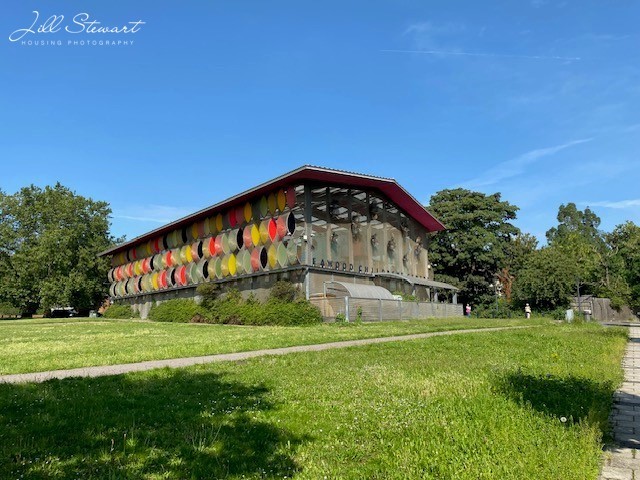
The London Outer Orbital Path – better known as the London Loop – is a 150 mile trail that circles the fringes of Greater London. It’s split into 24 sections beginning in the east, in clockwise direction, at Erith station on the south bank of the Thames and ending at Purfleet in the north. It’s a wonderful mix of genuine countryside, public open space and suburbia with a few more urban patches thrown in. We completed the walk between 2020 and 2021. While most people don’t do the walk to see council housing, I couldn’t resist recording it along the way.
Section 1: Erith to Old Bexley
Carrack and Bosworth Houses
The 13-storey Carrack House and 14-storey Bosworth House, containing 52 and 56 homes respectively, were commissioned by the new London Borough of Bexley in 1967.
Crayford Way, Barnes Cray
The Barnes Cray Estate was built by Vickers with the aid of a War Office grant to house their employees at the nearby munitions works between 1915-16. Designed in garden suburb style by J Gordon Allen, half the 600 homes were of non-traditional, concrete block construction.
Cray Close, Crayford
Crayford Urban District Council extended the estate northwards after the war.
Halcot No. 2 Estate
Bexley Urban District Council acquired part of the Halcot and Hall Place Estates for house building to the north of Bourne Road in 1938. Part of the land was preserved as open space, the Halcot No. 2 Estate was begun after the Second World War.
Section 2: Old Bexley to Petts Wood
Saxon Walk, Foots Cray
Saxon Walk, Foots Cray Estate, built by Bexley Borough Council in the later 1960s or 1970s, I’m guessing.
Suffolk Road, Foots Cray
A modest 1960s terrace in Suffolk Road, Foots Cray
Cuxton, Petts Wood
Cuxton, a small block of flats built by Bromley Borough Council in the 1970s next to the new Petts Wood Library.
Section 3: Petts Wood to West Wickham Common
Coppice Estate
The Coppice Estate near Petts Wood was begun by the Municipal Borough of Bromley in the interwar period and completed after World War II.
Larkfield and Kemsing Close, Hayes
A modest scheme of council flats built in the 1960s, I’d guess. If so, by the new London Borough of Bromley formed in 1965.
Section 4: West Wickham Common to Hamsey Green
Broadcoombe
Edgecoombe
The land for the Monks Hill Estate was bought by the County Borough of Croydon, then in Surrey, in 1945 and developed as a council estate from the 1940s.
Section 5: Hamsey Green to Coulsdon South
Tithepit Shaw Lane, Warlingham
On Tithepit Shaw Lane there is a small, early post-war council estate, built by Caterham and Warlingham Urban District Council, I think.
Section 6: Coulsdon South to Banstead Downs
The Clockhouse Estate
The Clockhouse Estate, north of Coulsdon, was begun in 1934 but the bulk of its development by Carshalton Urban District Council took place after the Second World War with blocks of flats built in the 1950s and 1960s. It’s presently located in a cut-off corner of the London Borough of Sutton with Croydon more convenient for most residents.
Little Woodcote smallholdings
The Little Woodcote scheme was created by Surrey County Council for ex-servicemen under the1919 Land Settlement (Facilities) Act – part of Lloyd George’s promise of ‘homes for heroes’: originally 81 smallholdings of around three acres each and weatherboarded semi-detached housing.
Section 8: Ewell to Kingston Bridge
Surbiton Hill Park
Attractive cottage flat council homes on Surbiton Hill Park, built by Surbiton Urban District Council (a borough from 1936).
Lower Marsh Lane
Addison Gardens and Lower Marsh Lane, Surbiton: a small council estate built by Surbiton Borough Council just after the Second World War. Addison Gardens is presumably so named after Christopher Addison, the reforming housing minister responsible for the 1919 Housing Act.
Section 9: Kingston Bridge to Hatton Cross
Connaught Road, Mays Estate
We’ve crossed the Thames into the London Borough of Richmond. The Mays Estate was built by Teddington Urban District Council under Addison’s 1919 Housing Act and completed in 1921 – a powerful testament to the ‘Homes for Heroes’ ideals of the day.
The Sparrow Farm Estate
The Sparrow Farm Estate, now in the London Borough of Hounslow, was built by Feltham Urban District Council in the 1950s. According to local MP Albert Hunter in 1959, ‘visitors from abroad have been shown this housing estate as an outstanding example of our post-war housing construction’.
Hounslow Heath Estate
The Hounslow Heath Estate, in Hounslow, approved in 1965, was one of the first housing schemes of the new London Borough of Richmond. Built by Wimpeys with two 15-storey tower blocks at its heart.
Section 10: Hatton Cross to Hayes & Harlington
Skeffington Court
The 15-storey Skeffington Court in Hayes, built by the London Borough of Hillingdon, was begun in 1971 and named after local Labour MP Arthur Skeffington who died that year. It was opened by Harold Wilson.
Corwell Gardens
The Corwell Gardens estate in Hillingdon was built by Hayes and Harlington Urban District Council in the 1950s – a Labour-controlled council and prolific builder of council homes for most its history. The estate is a good example of the mixed development of the era.
Section 11: Hayes & Harlington to Uxbridge
Council housing on Church Lane in Uxbridge Moor built by Uxbridge Urban District Council in the 1930s
Later flats built off Cowley Mill Road, Uxbridge, now part of the London Borough of Hillingdon.
Section 12: Uxbridge to Harefield West
Truesdale Drive
Moorhall Road
Dellside
South Harefield where Uxbridge Urban District Council began a large interwar estate around Truesdale Drive in the 1930s and later some fine homes along the new Moorhall Road. The houses on Dellside, at the bottom, have a particularly idyllic setting on the fringes of the Colne Valley.
With twelve sections to go and 74 miles left, we’ll take a break till next week.
I’m very pleased to feature this new guest post by Michael Passmore. Michael is a historian specialising in housing and town planning after a career in estate management. In 2015, King’s College London awarded Michael a PhD for a thesis on the politics of council housing between 1971 and 1983. Since 2015 Michael has been affiliated to University of Greenwich, first as a visiting lecturer and currently as a visiting fellow. He engaged in organising with Professor Mark Swenarton and others the successful 2019 Homes Fit for Heroes Centenary Conference at the Institute of Historical Research, London University.
Charlton in South–East London is known for its fine Jacobean mansion, Charlton House, and for The Valley football ground where Charlton Athletic first played in 1919. A less well-known part of the district’s heritage is the Guild Estate, part of Greenwich Council’s contribution to the Lloyd George government’s Homes Fit for Heroes campaign. It forms a section of Charlton Estate comprising some 440 cottage-style semi-detached and terraced houses.
An observant visitor to Charlton might notice a pointer to the significance of this 1920s estate from an ornate plaque (or tablet) on the front wall of a pair of semis at the eastern end of The Village. It records the names of some dignitaries of Greenwich Metropolitan Borough and others involved in developing the first phase of the estate during 1919–21.
The name of the construction company inscribed is ‘Guild of Builders (London) Limited.’ This was one of several building guilds, set up as part of a short-lived movement following the First World War. My research reveals that the homes in Charlton are the only ones that a guild erected in the former County of London, although the London Guild also built Higham Hill Estatefor Walthamstow Urban District Council just over the county border.
Initially, the proponents of the guilds had lofty expectations. During 1920, G.D.H. Cole, the Oxford academic and leading theorist of the guild socialist movement, saw the London branch in action and welcomed the contribution its members were making. He had hopes that “The guild system would develop into as great a movement as the co–operative movement.”
Guild of Builders
The guilds were created at a time of unrest among working people that had been fomenting since the First World War especially over poor working conditions and squalid housing. There were dreams of replacing private enterprise with a new form of business organisation through workers’ control. In April 1920, Richard Coppock, a young trade union official in Manchester, set up a national building guild with Samuel (S.G.) Hobson, a political idealist, who was one of the people involved in founding Letchworth Garden City. (Coppock later became Chairman of London County Council.) The guild was an alliance of several independent unions representing building workers and known as the National Federation of Building Trade Operatives (NFBTO). Hobson became General Secretary of the national guild.
The guild aimed to make decisions democratically, to improve the status of building workers and to achieve high standards by reviving artisanship in the industry. Echoing ideas of John Ruskin and William Morris, the guild aspired to do work worthy of the Middle Ages. Workers formed self-governing branches including the one in the London area, although most were in the north of England. Unlike the prevailing practice on building sites, the guilds aimed to continue paying worker–members when bad weather prevented activity as well as during holidays and sickness. Many labourers and skilled workers responded enthusiastically to an opportunity to participate in the new venture.
The housing campaign associated with Health Minister Christopher Addison’s Act of 1919 generated plenty of building work and so presented an opportunity for newly formed building guilds to participate where local councils were prepared to engage them. Addison initially encouraged their involvement because private contractors showed little interest in building council housing.
The London Guild of Builders was set up on the lines of a model constitution recommended by the National Guild with Malcolm Sparkes as secretary. He was a Quaker who at one time ran his own building firm.
London Metropolitan Boroughs
Political control changes in Greenwich Town Hall
Before municipal elections took place in November 1919, the Conservatives, who operated in London local government as the Municipal Reform Party, had controlled Greenwich Council for two decades. As in several London boroughs and to the surprise of many, the Labour Party became the majority party on Greenwich Council in 1919. If it had not done so, the inexperienced London Guild might not have succeeded in building the council’s first housing project. A close relationship quickly developed between the new council and the guild when it came onto the scene. Nevertheless, councillors across the political divide adopted a bipartisan approach over participating in the government’s Homes Fit for Heroes campaign.
The newly elected council decided to retain the experienced mayor, solicitor Sir Charles Stone, not least because there was no financial allowance at a time when most Labour councillors were in full-time employment. By the following year, when a stipend was available for the office of mayor, the council appointed a leading Labour member – Benjamin Lemmon, a marine engineer and energetic trades unionist.
Work starts on the scheme
By the time that the Labour leadership took on its responsibilities, the council had identified forty acres of greenfield land of irregular shape. Only a small part was in its ownership and most of the site was being acquired from Sir Spencer Maryon-Wilson whose family had owned Charlton House and much of the area for centuries. The development land skirted three sides of a 30-acre wood that Maryon-Wilson was in the process of donating to London County Council for use as a public park. This helped make the housing site attractive because Christopher Addison advised local authorities to build estates near open space so that tenants would have easy access for recreation.
Glimpses of Maryon Wilson Park
In 1925, Greenwich Council was to acquire Charlton House from Maryon-Wilson with its 40-acre park opposite the new estate, thus adding to the local amenities.
During its first six months, the new council made substantial progress with the housing scheme. Having obtained Whitehall’s approval to the site, the council appointed a Greenwich-based architect, Alfred Roberts, to draw up an estate layout (with the borough engineer) and design the houses. Roberts and the council settled on four building types ranging between two and four bedrooms and all were to have bathrooms.
Planned estate layout (left) and final street plan
On 10th July 1920, a customary ‘cutting the first sod’ ceremony took place to mark the start of construction works. Alderman Lemmon, who chaired the event, explained to the gathering that the Housing Ministry had approved plans for the scheme and that the necessary funds were available. He blamed the nation’s housing problem for much of the prevailing industrial unrest. Lemmon was delighted that the woodland next to the new homes was to become available for public use.
Meanwhile, a firm of private contractors began work on an initial phase of eighteen houses on a strip of land detached from the main site and fronting onto Kinveachy Gardens, an established residential road. The recently formed London Guild lobbied the council for the job but missed the date for submitting a tender price. They made sure that they met the conditions for the main contract.
As the London Guild submitted the lowest tender for building 164 houses on the main site, the council quickly settled the contract details with them. Most of the new homes were to have three bedrooms.
Types of houses
Included in the contract were another 26 homes on a strip of land to the west of Charlton Village that was to become Mascalls Road. The council agreed to pay for the work in stages as building progressed. This enabled the guild to raise the working capital needed for its operation from the Co-operative Bank that served trade unions. As Whitehall officials were slow in approving the terms of the contract, it was not until late 1920 that they gave Greenwich the go-ahead to start work. By this time there was a waiting list of workers wanting to join the guild and within a few months, a local newspaper reported that there were 300 on site.
Design of the homes
The authors of the South London volume of the popular Pevsner Architectural Guides recommend their readers to look at the estate to see what they describe as the ‘straightforward pantiled and roughcast cottage housing.’ This entry captures the more attractive features of the homes although in recent years alterations to many of the exteriors are out of character with the original designs.
When preparing the drawings for the new Greenwich homes, Alfred Roberts followed the official housing design manual issued to local authorities. This publication was in line with the report Sir Raymond Unwin edited on the Tudor Walters Committee, which the government set up in 1916 to improve the standard of working-class housing. The manual included plans of several types of model home but allowed for variations to suit local conditions.
Roberts would have been aware of the picturesque estate at nearby Well Hall, Eltham, designed during the war by Sir Frank Baines of H.M. Office of Works. However, the manual made it clear that designers should avoid the expense of unnecessary ornamentation, although the Health Ministry did not object to Roberts including the Arts and Crafts motif of a rising sun in brickwork on some semis. Again, to reduce costs, Unwin urged councils to use standardised building components where possible, so Roberts specified precast door hoods and steel casement windows. The council wanted the latter to be in wood, but the ministry ruled out this traditional material as it was slightly more expensive. There was variation in the roof coverings as the architect substituted slates when tiles were unavailable.
Some design features
Grand opening
The event to celebrate completion of the first homes took place on Saturday 2nd July 1921. In readiness for the occasion, two departmental stores – the Royal Arsenal Co-operative Society and Cuffs of Woolwich – each furnished a new home to show what tenants could buy. These show houses remained open to the public for several days as there was keen interest from local people.
Newspaper advert
At the crowded ceremony, the previous mayor Sir Charles Stone and others praised the high quality of the building work. Mayor Lemmon declared that he identified with others living in squalid conditions by revealing that he and his wife, belonged to the great mass of people who were cooped up in small rooms in bad surroundings’. He referred to a government announcement that they were halting the house-building programme when he criticised them for not doing enough to support the council in tackling the housing shortage.
Secretary of the London Guild, Malcolm Sparkes, proclaimed that the guilds were a new industrial system whose growth had only reached the stage of a year-old infant. Unfortunately, at the time of the formal opening, the national economic climate was deteriorating.
Events turn against the guilds
Alfred Mond, who replaced the progressive Addison as Health Minister, had earlier favoured the guilds, but now changed the way housing schemes were financed to the detriment of the guilds. Private contractors were putting pressure on the government by complaining that it favoured guilds unfairly.
In Greenwich, the London Guild put in a tender to build the next phase of the estate known as the Pound Park section, but private contractors undercut the pricing. The housing committee still preferred the guild because of its proven reliability, but ministry officials persuaded them to accept the tender from a Birmingham firm.
For a while, the National Guild and local branches merged, but by the end of 1922 the movement was failing financially. The Cooperative Bank was not prepared to make further loans without collateral that was beyond the organisation’s capacity. It signalled the end of the experiment and, sadly, the winding up of Guild of Builders (London) Ltd. took place in 1924. So, the growth of the industrial system that Malcolm Sparkes envisioned never reached maturity. Nevertheless, the London Guild completed its section of the Charlton Estate satisfactorily, leaving a legacy of well-built homes for future generations.
I’m pleased to feature today a new guest post by Dr Alistair Fair. Alistair is a Reader in Architectural History at the University of Edinburgh and a specialist in post-1919 architecture in Britain. He first discovered the work of the architectural practice Peter Moro and Partners when writing a history of British theatre architecture between the 1940s and 1980s (published in 2018 as Modern Playhouses, and recently re-issued in paperback). He has since written a book specifically about Peter Moro and Partners, which was published in September 2021. His current work includes a collaborative study of Scotland’s new towns, and an investigation of ideas of ‘community’ in twentieth-century Britain. You can follow him on Twitter @AlistairFair
Peter Moro and Partners was a small but well-regarded London-based architectural practice which was active between the 1950s and the 1980s. Its work, which was almost entirely for public-sector clients, included several notable estates in London. Their design demonstrates well the growing search, during the 1960s and 1970s, for innovative ‘high density, low rise’ estate layouts.
Peter Moro was a German refugee who came to Britain in the mid 1930s. He initially worked with Berthold Lubetkin’s pioneering Modernist practice, Tecton, on projects including the Highpoint 2 flats in north London. A move into independent practice led to the co-design of a very well-received large house on the Sussex coast, just before the outbreak of the Second World War. Then, at the end of the 1940s, Moro was head-hunted to join the design team working on the Royal Festival Hall in London; his work involved overseeing the detailed design of the interiors. Moro was thus well-placed to become a specialist in theatre design, just as Britain experienced a building boom in subsidised regional theatre-building. (1)
Moro’s involvement in the Festival Hall did not simply establish him as a theatre specialist, however. It also led to further work for the London County Council (LCC) and the subsequent Greater London Council (GLC). These jobs included several housing estates. The largest was at Thirza Street, Shadwell, to the north of Cable Street. Now known as the Barnardo Gardens estate, it was completed between 1967 and 1972 and replaced a patchwork of housing condemned as unfit. The site was bisected by a railway line, with the architects proposing 130 flats in two U-shaped groups of buildings. Low-rise blocks were set around the perimeter, with a single fourteen-storey tower adding a vertical accent. The southern (Cable Street) frontage included a public house and clubroom as well as flats for the elderly. At the centre of the estate was a play area, set on a podium above garages and parking. The buildings were originally largely faced in red brick, though the concrete floor slabs were left on show, with the deliberate choice of an aggregate-rich concrete mix adding texture. Bridges between the low-rise buildings were also made of concrete, their large eight-sided openings adopting a shape which appeared in many designs by Moro and his colleagues from the mid-1960s onwards. The raised podium was removed early in the 2000s, while the central and southern parts of the estate have been remodelled.
In 1967, a perspective drawing of the Thirza Street development was shown at the Royal Academy, where it caught the eye of Hans Peter ‘Felix’ Trenton, architect for the newly created London Borough of Southwark. Over the course of the next fifteen years, Peter Moro and Partners designed several estates for the borough. Much of this work was overseen by Moro’s partner in practice, Michael Mellish, with important contributions from numerous other colleagues.
The London Borough of Southwark was created as part of the reorganisation of the capital’s local government in 1964, bringing together three former Metropolitan Boroughs: Bermondsey, Camberwell, and Southwark. In 1966, the new authority reported that housing conditions were such that 2000 new homes were needed in the borough each year until 1981. When it came to the design of these homes, the former borough of Camberwell had already rejected the typical 1950s inner London strategy of housing design, namely picturesque ‘mixed developments’ of towers, maisonettes, and houses. Instead, the Aylesbury estate (1963-67) was more uniformly medium-rise, and this approach was rolled out across Southwark in the late 1960s.
This move reflects a contemporary shift away from high-rise housing. It partly was the result of increasing unease with ‘mixed development’; also important was growing criticism of isolated tall blocks. These debates led during the late 1950s and 1960s to a number of key projects elsewhere, such as Lillington Gardens in Pimlico (Darbourne and Darke, 1961-71), and the Brunswick Centre, Bloomsbury (Patrick Hodgkinson from a scheme with Leslie Martin, 1961-72). In addition, the subsidy regime introduced by the 1956 Housing Act, which had favoured tall buildings, was abandoned at the end of the 1960s in favour of new cost ‘yardsticks’, and this, too, prompted particular interest in so-called ‘high density, low rise’ layouts. The examples designed by Neave Brown and colleagues for the London Borough of Camden are particularly well known, not least thanks to the research of the historian Mark Swenarton, but there are notable examples elsewhere in London – particularly in Lewisham and Southwark.
An early example in Southwark was Neylan and Ungless’ Limes Walk development in Peckham (1964-66), with two long terraces facing a pedestrian walkway. Reflecting growing interest in ‘vernacular’ detailing, Southwark’s developments increasingly featured brick elevations and tiled roofs, among them the Setchell Road development by Neylan and Ungless (1971-78), where a dense mixture of flats and houses is arranged around courtyards and pathways. Within this context, the estates designed by Peter Moro and Partners tended in terms of their design towards the rational rather than the picturesque or neo-historical. The need for high densities with a wide dwelling mix – from small flats to family dwellings – led to intricate, innovative and well-considered cross-sections. A key aim was the maximum possible amount of private open space, in the form of gardens or terraces.
An early scheme was at 76-78 Montpelier Road, Peckham (1969-74), a small brick-clad block sympathetic to the scale of the adjacent terraces. A 1976 guide to recent London buildings by Charles McKean and Tom Jestico thought it contextual without being imitative, ‘skilfully designed and well built’, noting how ‘well-chosen materials’ plus careful detailing had made ‘a very small stairway into a pleasant space’. (2)
Hamilton Square section, drawn by Nick Mols
It was followed by two larger estates. At Coxson Place, Bermondsey (1969-75), flats and maisonettes were built alongside new premises for the Downside Settlement (a boys’ club). The housing was arranged in two parallel blocks, separated by walkways on two levels, with a complex mixture of house types melded together into a building of deceptively simple appearance. A similar arrangement was used at Hamilton Square, close to Guy’s Hospital (1969-73). Flats and maisonettes are arranged in two bands of buildings, between which is a landscaped podium above garages and parking. The impression externally is of a cascade of brick-faced terraces and balconies, stepping up through the site. As at Coxson Place, the arrangement of the dwellings is complex, and the product of much thought. The larger flats and maisonettes have several levels and half-levels, with some stepping across the open walkways to reach their own terraces. The Architects’ Journal praised the design: ‘the architects have performed a small miracle in achieving an exceptionally high density within a maximum four storeys, each dwelling planned to Parker Morris standards and each with the bonus of a respectable private outside space. (3)
Less complex in layout but demonstrating many of the same ideas is a development at Pomeroy Street, Peckham (1974-78), which combined a linear block of flats and maisonettes on the street-facing front with terraced housing in the gardens to the rear. The design was contextual in its brick, and its scale, with the length of the block intended ‘to re-establish the linear form of Pomeroy Street’ whilst being broken up by gables and balconies intended to identify each dwelling and to ‘give a variety of views […] which conventional terrace housing often lacks’. (4) Writing in Building Design, John McKean praised the scheme’s combination of humane atmosphere and urban scale.
There were other projects in the borough. Earl Road/Rowcross Street (Wessex House, 1971-74) echoes James Stirling’s 1960s designs in its bright red brickwork and angled geometries. Brimmington Central (Blanch Close), meanwhile, was completed in 1981, with flats and houses plus a small parade of shops which Moro’s team developed from Southwark’s own in-house designs. A final larger development, the Pasley Estate, Kennington, was begun in 1975 and completed in 1982. Deliberately picturesque, its brick-clad, low-rise blocks of housing snake around and through the site, being crowned with pitched roofs.
Things seemed to be on a roll, but, by the late 1970s, inflation and recession were challenging the economic (and political) assumptions of the previous thirty years. The introduction of the nationwide ‘Right to Buy’ policy in 1980 further affected the landscape of council housing. The result was a sudden reduction in the numbers of new council houses being constructed. That year, the Illustrated London News commented that it was ‘sad and strange that, having taken two decades to discover the kind of municipal housing its citizens like and want, Southwark now finds itself without the cash to build them’. (5)
Within this body of work, the contribution of Peter Moro and Partners is notable. The Buildings of England volume for south London not only highlights the quality of Southwark’s 1970s housing in general, but the contributions of Moro’s office in particular. (6) These projects demonstrate well not only the ways in which local authorities and their designers in 1970s London sought to provide excellent new housing of often innovative form, but also the evolving nature of the ‘welfare state’ project and its architecture during a decade that is all too easily written off as a period of crisis and decline.
To buy a copy of Peter Moro and Partners for £21, use code LUP30 at the publisher’s website.
References
(1) For more on this, see e.g. Alistair Fair, Modern Playhouses: an architectural history of Britain’s new theatres (Oxford, 2018).
(2) Charles McKean and Tom Jestico, Guide to Modern Buildings in London, 1965-75 (London: RIBA, 1976), p. 58.
(3) Hamilton Square Redevelopment’, Architects’ Journal, vol. 157, no. 9 (9 May 1973), pp. 1116-17.
(4) ‘Queens Road Development’, 9 February 1979, typescript by Michael Mellish. RIBA, MoP/1.
(5) Tony Aldous, ‘New Housing Solutions in Southwark’, Illustrated London News, October 1980, p. 26.
(6) Nikolaus Pevsner and Bridget Cherry, London 2: South (New Haven and London: Yale University Press, 2002), p. 562.
I’m very pleased to feature this new guest post and some fine photography by Thaddeus Zupančič. Thaddeus is a Slovenian-born writer and translator. He has lived in London since 1991. For the first 14 years he worked as a radio producer with the BBC World Service. On his Instagram account @notreallyobsessive he is now about one third through his project, London Modernism 1946-1981, which documents modernist council estates in the capital. He is also a volunteer with The Twentieth Century Society and manages its Instagram account @c20society.
On Sunday, 23 January 1955, Margaret Willis, a sociologist in the Planning Division of the Architect’s Department of the London County Council, gave a broadcast on the BBC Home Service programme Home for the Day.
Her bosses thought the broadcast, in which she ‘would informally talk about her work at County Hall’, was ‘in the interest of the Council’ and therefore recommended that ‘under Staff Regulation 112’ she should be allowed to retain the fee (‘probably 8 guineas’).
The eight-minute talk was titled My Job. Willis explained that a sociologist is a ‘sort of liaison officer between people like you, the housewives, and the Council’s technical men and women who make the plans in the drawing office’. She was, though, mostly talking about the scarcity of land in ‘the centre of our cities’ and how planners and architects ‘realise how important gardens are to many people and they are doing their best to provide them’. One of their ideas, she explained, was to build ‘a compromise between a house and a flat, it’s a four-storey building like a house on top of a house’. The main benefit of these buildings was the attached gardens, but there was also something else: ‘People prefer this type of building to a flat because they like going upstairs to bed.’ (1)
Such ‘houses on top of houses’ – known as maisonettes because of their split-level plan – were not a complete novelty. On the Devons Estate in Bromley-by-Bow, for instance, there are four low-rises which look like terrace houses with separate flats on the top of them, basically ‘flats on the top of houses’. It is an unexciting, but useful Neo-Georgian pastiche. Pevsner is more damning: the estate, opened in 1949, is ‘entirely in the LCC’s pre-war manner, but with all the drabness of post-war austerity’. (2)
Brett Manor, Hackney, by Edward Mills for the Manor Charitable Trustees, 1947-8
The first modernist maisonette block in London was Brett Manor in Brett Road, Hackney, built in 1947-8. It was designed by Edward Mills for the Manor Charitable Trustees (Mills used the same Arup box frame as Tecton did at Spa Green Estate, which was completed in 1950).
Brett Manor was swiftly followed by Powell & Moya’s Bauhausian low-rise blocks at Churchill Gardens in Pimlico (designed from 1946, built in 1947-51), which were the first modernist maisonettes built by any London council, in this case Westminster.
Winchfield House, Alton West, Roehampton, by the LCC Architect’s Department; designed in 1952-3, built in 1955-8
Margaret Willis’s employer was not far behind. Already in the early 1950s, as Elain Harwood points out, a group at the LCC Architect’s Department, worked on ‘an efficient maisonette plan, which they then cast into ten-storey slabs, built at Bentham Road, Hackney, at Loughborough Junction, Lambeth, and, most impressively, the Alton West Estate, Roehampton.’ (3) (The Gascoyne Estate in Hackney was built in 1952-4; the Loughborough Estate in 1956-8; and the Alton West Estate in 1955-8.)
The LCC dotted various iterations of these Corbusian slabs on stilts all around the central London metropolitan boroughs, including Southwark (Symington House in 1957, and Prospect House in 1962); Bermondsey (Chilton Grove in 1959); Lambeth (Wimborne House in 1959, Waylett House and Duffell House in 1963); Bethnal Green (Westhope House and Kinsham House in 1956, Yates House and Johnson House in 1957, Orion House in 1962); Stepney (Raynham House and Gouldman House in 1958, Withy House in 1959, Troon House in 1961 and Butler House in 1962); Poplar (Storey House in 1958 and Thornfield House in 1960); Westminster (the towers of the Maida Vale Estate in 1961 and Torridon House, albeit designed in 1959 only completed in 1969); and Islington (Muriel Street in 1964).
Westhope House, Hereford Estate, Bethnal Green, by the LCC Architect’s Department, 1956
Private practices working for the LCC were also designing maisonette slabs and blocks for them, the most impressive being the Ricardo Street Scheme at the Lansbury Estate in Poplar by Geoffrey Jellicoe (for the Festival of Britain’s Exhibition of Architecture, 1951); the Cordelia Street Scheme on the same estate by Norman & Dawbarn (1963); and the Fulbourne Estate slab and block by Stillman & Eastwick-Field (1958-9) in Whitechapel.
Maisonettes, regardless of the type of building in which they were incorporated, were an integral part of mixed developments, ‘the dominant ideology for housing i n the 1950s’ (4).
There was, though – as it is explained in the oddly self-flagellating GLC book Home Sweet Home – a problem with maisonette slabs: their ‘mass was too dominating, and problems of overshadowing and inflexibility of orientation led to planning difficulties which limited its use in high-density areas’. (5) A far greater potential, continues the book, was offered by the point block with its ‘non-directional shape and quick-moving shadow’.
After the success of Draper House on the Draper Estate in Elephant and Castle (completed 1962), the ‘tall blocks of maisonettes’ (6) became almost as ubiquitous as the slabs, most successfully in the case of the six 21-storey blocks on the Warwick Estate in Westminster (completed in 1966), though the medium-rise maisonettes on this estate are just as compelling.
Argosy House and, at back, Aragon Tower and Daubeney Tower, Pepys Estate, by the LCC Architect’s Department and, after 1965, GLC Department of Architecture and Civic Design; designed from 1963, opened in 1966, completed in 1973
Even taller, at 24 storeys, were the blocks of maisonettes of the cross-over ‘scissors’ type on the Pepys Estate (designed from 1963, completed in 1973) in Deptford and the 26-storey Maydew House on the Abbeyfield Estate (1965-8) in Southwark. The ‘scissors’ type was first tested for the LCC’s Lincoln Estate blocks in Poplar (1959-62), but ‘later discontinued owing to the high cost of its complex construction’. (7) The construction was indeed complex, with central corridors placed at a half level, ‘providing entrances to flats that ran the width of the block above or below, ‘crossing’ to give each other a dual aspect’. (8) They also provided a maximum of through light and ventilation. Even better than the 24-storey blocks on the Pepys Estate are the eight-storey ‘scissors’ maisonettes, a ‘strong, unifying element of the scheme’. (9)
‘Houses, flats and maisonettes’ was a mantra not only for the LCC, but also for London’s metropolitan boroughs and the City.
Golden Lane Estate, City of London, by Chamberlin, Powell & Bon for the Corporation of London; design won in competition in 1952, built to revised designs in 1954-6
The best examples of the latter are the Golden Lane Estate by Chamberlin, Powell & Bon for the City (which consists of various blocks of flats and six blocks of maisonettes plus a community centre, swimming pool and a tennis court, 1954-6); and Denys Lasdun’s part of the Greenways Estate for Bethnal Green Borough Council (the two inventive eight-storey cluster towers with 24 maisonettes each and the three low-rise blocks with another 50 maisonettes, 1955-8) as well as his Keeling House (for the same council, completed in 1959, originally comprising 56 maisonettes and eight studio flats).
Trevelyan House, Greenways Estate, by Denys Lasdun of Fry, Drew, Drake & Lasdun for Bethnal Green Metropolitan Borough Council; designed in 1952-3, built in 1955-8
Equally busy were Skinner, Bailey & Lubetkin (the post-Tecton maisonettes on the Dorset Estate, 1951-7, and the Cranbrook Estate, 1955-65, both for Bethnal Green, and the Tabard Garden Estate Extension in Southwark, 1964-5, for the LCC); Frederic Gibberd (Kingsgate Estate, 1958-61, for Hackney); George, Trew & Dunn (Winstanley Estate, 1964-6, for Battersea); Clifford Culpin & Partners (Edgecombe Hall Estate, 1957-63, for Wandsworth); and Co-operative Planning (St John’s Estate, 1963, for Poplar).
Jim Griffiths House, Clem Attlee Court, by J. Pritchard Lovell; Fulham’s Borough Architect and Director of Housing; 1957
So too were the borough architects of those metropolitan and municipal councils that already had them – most notably Camberwell’s F.O. Hayes (Sceaux Gardens, 1957-60; and the Astley Estate, 1957-9); Fulham’s Borough Architect and Director of Housing J. Pritchard Lovell (Clem Attlee Court, 1957); Willesden’s T.N. l’Anson (the 1963 blocks in the South Kilburn Redevelopment Area with maisonettes on the top of flats); and T.A. Wilkinson at Edmonton (Cumberland House and Graham House on Goodwin Road, 1962). Only five out of the twenty-eight metropolitan boroughs had their own borough architects (of whom four were also directors of housing). Just as busy were the borough engineers and surveyors, for instance W.J. Rankin at Poplar (the first phase of the St John’s Estate, 1956; the Alfred Estate, 1959-60; and the Aberfeldy Estate, 1962-3).
Lakanal, Sceaux Gardens, by F.O. Hayes, Borough Architect, H.C. Connell, A.W. Butler and H.P. Trenton of the Camberwell Borough Architect’s Department, 1957-60
Graham House, Goodwin Road, by the Edmonton Architect’s Department under T.A. Wilkinson, 1962-3. On the right: Walbrook House by the Enfield Borough Architect and Planning Officer’s Department under Wilkinson, 1967-8
The reorganisation of London’s local government in 1965 saw the creation of the new Greater London Council and 32 new London borough councils (plus the City) which then became responsible for a substantially larger part of housing projects and planning than before.
More importantly, the London Government Act of 1963 introduced – in s.74(1) – the statutory post of ‘an architect for the borough’ (10) in each one of them and, ‘as the case may be’, the City.
The most celebrated of them was Sydney Cook, who established Camden’s architect’s department. Cook recruited some of the best young talent – including Peter Tábori, Bill Forrest, Gordon Benson and Alan Forsyth – but the ‘first and foremost among those who joined Camden from the cutting edge of London’s architectural culture was Neave Brown’. (11)
Dunboyne Road Estate, Gospel Oak, by Neave Brown of the Camden Architect’s Department under Sydney Cook; designed in 1966-7, built in 1971-7
Brown designed two of the most remarkable post-1965 council estates in London: the Dunboyne Road Estate (a mixture of three- and two-bed maisonettes and one-bed flats; designed from 1966 and built in 1971-7); and the Rowley Way part of the Alexandra & Ainsworth Estate (block B, for instance, comprises four storeys of two- and three-bed maisonettes), built in 1972-8.
Tangmere, Broadwater Farm Estate, by C.E. Jacob, Borough Architect, and Alan Weitzel, Deputy Borough Architect of the Haringey Department of Architecture; designed from 1966, built in 1967-72
Cook’s competitor for Camden’s job was the housing architect of Hampstead, C.E. Jacob. He was later appointed borough architect of Haringey and as soon as his new Department of Architecture was set up, he designed, with his deputy Alan Weitzel, the Broadwater Farm Estate (1967-72) and its centrepiece, Tangmere, a maisonette ziggurat.
Henry Wise House, Lillington Gardens Estate, by Darbourne & Darke for Westminster City Council; design won in competition in 1961, detailed and built in 1964-7
Westminster balanced work of its own new Department of Architecture and Planning under F.G. West – such as the Brunel Estate in Westbourne Park, 1970-4 – with schemes by private practices, for instance Darbourne & Darke’s epochal Lillington Gardens Estate (designed in 1961, built in 1964-72, with some of the best maisonettes in town); the scheme won numerous awards, starting with an Award for Good Design in Housing in 1969.
Spring Gardens, Highbury New Park, by the Islington Architecture Department under Alf Head, Borough Architect, 1968-70
In the period of 1968-1980, the most Awards for Good Design in Housing – sponsored by the Secretary of State for the Environment in collaboration with the Royal Institute of British Architects – was received by Islington, ‘more than any other local authority in the country’. (12) Islington’s Architecture Department was run by Alf Head, who complemented its own projects – for example the Spring Gardens (1968-70) maisonettes and flats in Highbury – with commissions from private practices, very often Darbourne & Darke.
Borough architects in south London were just as active, particularly F.O. Hayes at Southwark, who continued his old Camberwell job, and Ted Hollamby at Lambeth.
Dawson Heights, Dulwich, by Kate Macintosh of the Southwark Department of Architecture & Planning under F.O. Hayes; 1966-72
Southwark’s largest projects were the stupendous Heygate Estate (now demolished) and the Aylesbury Estate (demolition underway), but the Department of Architecture and Planning designed other estates too, such as the Four Squares Estate in Bermondsey (most of its 691 homes are maisonettes). The most triumphant, though, was Kate Macintosh’s all-maisonette estate Dawson Heights (1966-72) in Dulwich. She described it as a ‘Chinese puzzle of differing types to be assembled in various combinations’ (13) and it still works perfectly well.
The building programme in the neighbouring Lambeth was very extensive too – and Hollamby was as good at recruiting talented architects as Cook given that one of his first appointments was George Finch, who already made his name at the LCC with the Chicksand Estate in Whitechapel.
Holland Rise House, Stockwell, by George Finch of the Lambeth Architect’s Department under Ted Hollamby; 1967
Finch’s eight almost identical 22-storey maisonette towers, system-built by Wates – the first completed was Holland Rise House in Stockwell in 1967 – are as intelligent as they are generous; and his stunning Lambeth Towers in Kennington Lane (designed in 1964-5, completed in 1971) are maisonettes, incorporated in a freestyle, sinuous brutalist block.
Binsey Walk, Thamesmead, by the GLC Department of Architecture and Civic Design; designed from 1966, built in 1968-9 (demolished)
The last great hurrah of mixed development was Thamesmead, ‘basically a working-class Barbican’ (14), the heroic estate by the GLC Department of Architecture and Civic Design, the successor to the LCC Architect’s Department. The two architecturally most intriguing structures – Coralline Walk and Binsey Walk, both now demolished – were linear maisonette blocks built in 1967-8; and more maisonettes were included in the later stages of the development, Parkview (1969-79) and The Moorings (1971-7).
The most seductive of all other GLC maisonette blocks remains Perronet House (1967-70) in Elephant and Castle, which won a commendation in the 1971 Awards for Good Design in Housing.
And it was not only the GLC Department of Architecture and Civic Design: pretty much all private practices commissioned by the GLC also designed maisonettes, including the Smithsons (their Robin Hood Gardens, 1968-72, mostly consisted of large maisonettes); Ernő Goldfinger (Trellick Tower, 1972, as well as Balfron Tower, 1967, Carradale House, 1967-8, and a 1972 Burcham Street block on the Brownfield Estate); Trevor Dannatt (Norwood House on the Galloway Estate, 1969); and Architects Co-Partnership (Ethelred Estate, Lambeth, 1964-75).
Benhill Grounds, Brunswick Road, Sutton, by the Sutton Architect’s Department under Peter Hirst, 1978-9
The last two estates featuring predominantly maisonettes were Benhill Grounds by the Sutton Architect’s Department under Peter Hirst (1978-9), and the GLC’s Ferry Lane Estate (1977-81) in Tottenham Hale. That these two schemes should have been the last – mostly because of the 1980 Housing Act and its consequences – is a shame, because maisonettes are arguably the greatest housing gift that modernist architects bequeathed to London. They were – and rightfully remain – popular ‘because they gave greater privacy and the sensation of being in a house’. (15) Not to mention the fact that Londoners like going upstairs to bed …
A version of this article was previously published in Issue 5 of Journal of Civic Architecture (2020).
Sources
(1) Margaret Willis, ‘My Job’ transcript for a BBC broadcast, 23 January 1955; Report by the Clerk of the Council, 12 January 1955, London Metropolitan Archives
(2) Bridget Cherry, Charles O’Brien and Nikolaus Pevsner, The Buildings of England – London 5: East, (Yale University Press, 2005)
I’m very pleased to feature this week a guest post by Paul Wood. Paul is the author of three books about trees in London: London’s Street Trees, London is a Forest and London Tree Walks, and he writes the blog thestreettree.com.
London Tree Walks, published in October 2020, features a dozen walks around London from Acton to Walthamstow looking at the city through the trees found in it. One of the walks, ‘Architectural Utopias Among The Trees: A Pimlico Circular’, guides walkers through the Millbank and Churchill Gardens Estates. This guest blog looks at how trees have been used in planned housing developments since the end of the nineteenth century with particular focus on the Pimlico Estates.
Signed copies of London Tree Walks are available from the authorat this webpage.
By the end of the nineteenth century, trees in towns and cities had burst out of parks and squares to become established in new, urban and suburban settings across the UK and beyond. The opening of the Victoria Embankment in 1870 led to an almost overnight popularisation of planting trees in avenues, a phenomena that had hitherto been the preserve of great Continental cities such as Paris, where Hausmann’s grands boulevards had been attracting attention for several decades.
By the late nineteenth century, building houses among tree-lined streets had become an established practice for speculative builders wanting to attract the burgeoning middle classes to newly fashionable suburbs like Muswell Hill and Bedford Park. In Bedford Park, new street trees complemented those retained from the original fields, while in Muswell Hill, hundreds of London planes adorned the new avenues.
The Arnold Circus bandstand, Boundary Estate, surrounded by London planes
Planners and developers had realised that not only were trees an important part of a modern cityscape, they brought with them a host of benefits to those who lived near them. As the new craze for street tree planting reached fever pitch, it was only natural that the first public housing schemes should also have trees planted around them. The Boundary Estate in Shoreditch featured newly planted trees along its streets, mostly London planes and common limes, many of which, particularly those around Arnold Circus can still be seen. Rows of newly planted saplings feature in this photograph taken in 1903 soon after the estate opened.
Twenty years after the Embankment planting, Victorian engineers had taken on board the need to engineer tree planting into new road schemes, the complexity of which was outlined by Clerk of the Improvements Committee, Percy J Edwards in 1876: (1)
To secure the well-being of trees, pits were formed and filled with proper soil, and the footway surrounding the trees was covered with an open grating to admit the rain and air to the soil, and to enable it to be stirred and kept loose on the surface. The grating and footway were supported independently by girders over the pits, so as to prevent the settlement of the paving and the hardening of the ground around the roots of the trees.
Following similar principles, the trees seen at Boundary Road and the Millbank Estate constructed soon afterwards are extraordinarily well encased. High quality engineering means subsidence has not been an issue and big trees have been left to reach their full potential and are now a significant physical feature defining these estates as much as their architecture.
Original London planes between blocks on the Boundary Estate
Trees planted in some privately developed housing schemes, including Muswell Hill, have not fared so well with whole streets of mature trees disappearing. This is down to two main factors: the cost of maintaining large trees is significant, sometimes at a level local authorities have struggled to keep up with; and the costs of paying out to litigious residents whose homes, built speculatively often with relatively poor foundations, have been subject to subsidence.
Trees are frequently implicated in subsidence cases, their adventurous roots, insurers claim, drain water from London’s porous clay soils causing contraction and can also undermine buildings. Rather than fight these often difficult-to-prove cases, authorities will avoid costs and conflict by simply removing trees. This practice has led to avenues being depleted, removed completely or being replaced piecemeal with different species. This last practice can mean an architecturally consistent scheme planted with, for instance, London planes can become a hotchpotch of trees with differing characteristics, size and age.
Looking down St Oswulf Street, Millbank Estate. Note how the well maintained London planes lean away from the buildings
This is not the case on the Millbank Estate however, defined – even more so than the Boundary Estate – by its well-manicured and mature London plane trees. It was completed in 1902 and was an ambitious attempt at social housing, building on the experience of its smaller Shoreditch sibling. Millbank’s trees appear, 120 years after their installation, to be in great shape and add to the architectural rigour even more so than those on the Boundary Estate. It may be obvious, but unlike buildings, trees change dramatically over time, albeit in relative slow motion. They are also subject to differing management regimes which themselves change over decades and so reflect factors including fashion, economics and arboricultural practices whose impact becomes apparent over multiple human lifetimes.
View from Boundary Gardens past the trunk of an original London plane with newer field maples on Palissy Street
Today, the Millbank Estate has a near full and consistent complement of trees, virtually all of which are London planes, the urban tree species of choice in the late Victorian and Edwardian periods. The Boundary Estate has some fine planes too, but appears to be relatively less forested today. Historically it appears, the Boundary Estate was planted with planes interspersed with common limes – another species well adapted to urban situations, mature examples of which can be seen on Rochelle Street. Elsewhere a handful of weeping ‘Pendula’ cultivars of wych elm, an ornamental species relatively resistant to Dutch elm disease are present. One in the small garden behind Sandford House next to Club Row is typical.
Recently planted field maples on the Boundary Estate
These curious crown-grafted trees were much in favour during the nineteenth century and are often a feature of public parks, however the estate examples appear to be rather younger than the buildings, they are perhaps second-generation replacements of original trees. In more recent years, streets such as Palissy Street have been planted with Field Maple, a smaller and shorter-lived species than London plane, but nevertheless, a good hardy tree.
The Boundary Estate has, it seems, lost some of its trees over the years, and those that remain have been less strictly managed than those on the Millbank Estate. Both feature mature planes that now reach the full height and more of the buildings that once towered over them. They have been planted close to the buildings, in retrospect maybe too close, often they have grown at angles several degrees away from upright in search of light. Their presence in such proximity to the buildings is testament to the high specification of the entire estate.
Millbank Estate
To walk round the larger Millbank Estate today is to encounter an environment, both architectural and arboreal, that has been very well maintained over the years. With both estates, it is interesting to reflect on the planners’ original vision of how the trees would become integral to the estates over time. Did they consider the trees should be left to reach the heights seen today, or were they intended to be managed on a severe pollarding regime reflecting the fashions of the early nineteenth century? It is hard to know, or even if the longevity of the trees’ lives was considered.
Recently pollarded planes in winter on the Millbank Estate
Now though, and particularly in the summer, the mature trees’ canopies provide cool shade and, as evidence from elsewhere shows, traffic speed, noise and pollution are all reduced in such lush surroundings. Integral to the design of the estate was the inclusion of open space and the provision of trees.
Communal, mostly paved, areas are tucked away between the blocks, and the trees planted over 120 years ago line the streets running between them. London planes form something of a monoculture, which from a visitor’s perspective offers a harmonious aesthetic that sits well with the arts and crafts inspired architecture, but to a contemporary planner, this rigour may seem uninteresting and even risky given the spectre of plant pathogens that, like Dutch Elm Disease, can wipe out whole species in a very short time.
No trees grace the courts between blocks on the Millbank Estate, unlike those of the Boundary Estate
It was undoubtedly a radical move to include trees in these early estates; by the late nineteenth-century social class was embedded in their selection and planting. As Harold Dyos wrote in his 1960s study of the growth of Camberwell: (2)
The choice of trees, too, had its social overtones: planes and horse chestnuts for the wide avenues and lofty mansions of the well-to-do; limes, laburnums and acacias for the middle incomes; unadorned macadam for the wage-earners.
Dyos’ observation illustrates that the high standards employed in early public housing development goes against the norms established by private developers. London plane, the tree that is associated with grand public thoroughfares like the Embankment and aspirational new suburbs like Muswell Hill was also the tree chosen to soften and embed these new housing forms into the fabric of the city. It would have appeared to be the perfect tree for planting as it is attractive, fast-growing and able to cope with the industrial pollution of the day. Over the years, the trees have been well cared for, having been regularly pollarded to keep them an appropriate size and shape for their location.
Churchill Gardens
A short and interesting walk from the Millbank Estate through the stuccoed splendour of Thomas Cubitt’s Pimlico, Modernist Churchill Gardens illustrates how the relationship between trees and public housing has changed over the years, and represents what might be considered the pinnacle of post-war inner city landscaping.
London’s Second World War destruction provided planners with a rare opportunity to rebuild a modern city. Sir Patrick Abercrombie’s Greater London Plan of 1943 identified how war-damaged and slum housing could be cleared to make way for spacious modern homes with proper sanitation along with public open spaces. Born out of this optimistic vision, the Churchill Gardens estate was planned to provide 1,600 new homes.
The distinctive silhouette of Italian alders, Johnson’s Place, Churchill Gardens
Designed by the young architectural practice of Philip Powell and Hidalgo Moya, the estate’s development started in 1946, with the final blocks – those on the western side of Claverton Street – not completed until the 1970s. It is now a conservation area, with several of the oldest structures listed. Walking through the estate, it is possible to experience the utopian vision of large-scale planned housing. As well as one of the first, Churchill Gardens is one of the largest and most ambitious social housing developments with several innovations at its heart, notably the Accumulator Tower, a structure designed to hold hot water for heating the entire estate, which was pumped directly from Battersea Power Station across the river.
Perhaps the most striking thing about the estate is how it is enveloped by green space and mature trees. Unlike the eighteenth- and nineteenth-century urban ideal emphasising the separation of houses and greenery, Churchill Gardens represents a modernist vision of living among the trees. At every turn, mature hornbeams, tree privets, southern catalpas and other species are present. Well-kept gardens, tended by residents, pop up all over, and secret green corners among the tower blocks offer natural sanctuaries.
Johnson’s Place lime trees, Churchill Gardens
Unlike that other notable modernist development, the Alton Estate in Roehampton, where high quality architecture is scattered among a former Georgian parkland overlooking Richmond Park, the landscape at Churchill Gardens was planned from scratch. Consequently the trees reflect mid-twentieth century tastes that show both far greater species diversity and a modern sensibility regarding their purpose.
Unlike the Millbank Estate, the trees are no longer structural adjuncts to the built environment, instead they have become alternative focal points to the buildings. They act to soften the potentially brutalising effects of the monumental architecture, whose scale they cannot compete with. Between the slab blocks, gardens exist containing specimen trees which have more in common with park trees than street trees – a crucial difference between Churchill Gardens and the Millbank Estate, which has also led to different management practices.
A mature ‘Fastigiata’ hornbeam, one of the more frequent species of Churchill Gardens
Instead of well-pollarded planes, the trees here have been given ample space to attain fine maturity. Notable among the species are goblet-shaped hornbeams of the ‘Fastigiata’ cultivar, and evergreen Chinese tree privets, both neat, medium-sized trees. Elsewhere, a few larger trees like Italian alder, red oak, sycamore, Norway maple, southern catalpa and Japanese pagoda tree rub shoulders with smaller trees including ornamental cherries, magnolias and white mulberries. But perhaps the most exciting trees to look out for are an exceptional example of a southern European nettle tree next to Bramwell House, and a very rare (and poisonous) varnish tree next to Coleridge House.
Flowering magnolia, Churchill Gardens
According to Powell, the architects worked with a former Kew gardener on the landscape planting. As a result, Churchill Gardens is full of fine, well-tended trees that the people who live here are proud of and that help to foster a palpable sense of place and community.
Evergreen Chinese tree privet, Churchill Gardens
Trees have been part of our town and cityscapes for centuries, but their use on streets and among housing is a late nineteenth century innovation. As the first social housing schemes were built, tree planting was considered an essential part of their development. This impulse continued over subsequent decades with a shift away from London plane monocultures to much more diverse planting which, at its best can be akin to parkland or even botanical collections.
The use of trees within planned housing developments arguably reached its zenith in the heroic modernism of the post-war period expanding on new insights, derived from pioneering schemes like the Millbank Estate, into how buildings, people and trees interact. As estates have aged, the trees have too. Now we can reflect on the benefits of living among the trees and appreciate the grandeur they bring to developments through softening and humanising the architecture, while also providing seasonal interest and tangible environmental benefits.
Sources
(1) Percy J Edwards, History of London Street Improvements, 1855-1897 (London County Council, 1898)
(2) Harold Dyos, Victorian Suburb: A study of the Growth of Camberwell (Leicester University Press, 1966)