• Home
  • About
  • Contact me
  • Social Housing as Heritage
  • The map of the blog
  • Mapping Pre-First World War Council Housing

Municipal Dreams

Municipal Dreams

Monthly Archives: August 2017

Municipal Dreams Goes to Hull, Part II: Civic grandeur, service and convenience

29 Tuesday Aug 2017

Posted by Municipal Dreams in Hull, Municipal Trail, Planning, Town Hall

≈ 4 Comments

Tags

Gibberd, Yorkshire

We left Hull in last week’s post standing, figuratively at least, in its civic heart, Queen Victoria Square.  We’re looking at municipal Hull – the plans and promises as well as proud accomplishment.

Queen’s Gardens, which lie beyond Queen Victoria Square to the north-east, fall somewhere in the middle of that spectrum.  The area was once the Queen’s Docks, the first Hull docks constructed in the 1770s.  Obsolete by the interwar period, they were sold to the Corporation, infilled and opened (by Labour MP Herbert Morrison) as a park in 1935 and, as such, were a key element of the 1930s’ redesign of the city centre.   The fountain at the western end survives from that time but the Gardens as a whole were remodelled by Frederick Gibberd from the 1950s, building on the earlier Lutyens and Abercrombie vision for a new grand civic space, including assembly hall and winter gardens, which incorporated the Guildhall to the south.

Queens's Gardens Kenneth Carter relief
– Kenneth Carter reliefs in front of former Central Police Station, Queen’s Gardens

Those larger ambitions remained unfulfilled and the Gardens remain poorly integrated into the wider cityscape – an issue addressed by a new masterplan issued in 2013 – but it’s a lovely space and walk into them to appreciate some fine past and present landscaping and public art. (1)  Amongst the latter are reliefs by Robert Adams by the pond at the eastern end and five panels by Kenneth Carter on a northern wall in front of the 1959 former Police Station, both commissioned by Gibberd (a great patron of public art as we’ve seen in Harlow).

Queen's Gardens SN
– Queen’s Gardens, Wilberforce Monument and Hull College

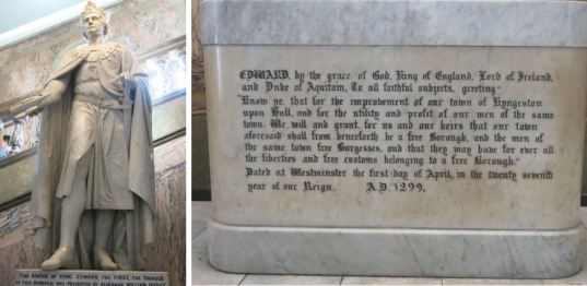
What will catch your eye is the grand terminal vista of the Gardens at their eastern end.  The Wilberforce Monument (local boy William Wilberforce was the town’s MP from 1780) was erected by public subscription in 1834, just one year after the slave trade against which Wilberforce campaigned tirelessly was abolished in the British Empire, and moved to its present site in 1935.

Hull College SN
– Hull College, Frederick Gibberd

Beyond it lies the Hull College of Technology (now Hull College), designed by Gibberd in Festival of Britain style in the 1950s, but completed in 1962.  Old Pevsner didn’t much like it – ‘run of the mill’ it thought – but the new guide is more complimentary of its ‘agreeable symmetry’.  A William Mitchell panel – depicting nautical and mathematical instruments – sits strikingly on the building’s façade.

Hull College Mitchell SN
– William Mitchell concrete and resin panel, c1960

From the College head south towards Alfred Gelder Street.  Alfred Gelder, an architect by profession, councillor and alderman for 43 years, was another of the nonconformist Liberals who left their progressive mark on the city.   The English Baroque-style Guildhall and Law Courts complex, designed by Edwin Cooper, on the street fittingly named after Gelder was begun on the latter’s initiative in 1905 and completed in 1916.  It’s a striking presence, monumental externally, lavishly decorated internally: a powerful statement of civic pride and purpose.
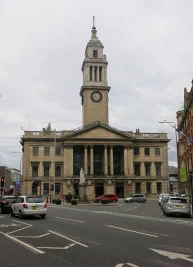
Guildhall SN

Guildhall II SN
– The Guildhall

Facing the Guildhall on opposite sides of the road are the Maritime Buildings, a fine Edwardian office block, Grade II listed, awaiting new use and some TLC, and the former General Post Office, fully justifying its architectural descriptor, Edwardian imperial.  Buildings of their time just as their current redundancy or repurposing indicates changed times.  A Wetherspoons in the former post office building allows you to see some of its former grand interior. (2)

Wilberforce Museum SN

Wilberforce Museum

From here it’s a short walk to the heart of Hull’s Old Town (the new town of the 14th century) and at the top end of the High Street, the city’s Museum Quarter – three excellent museums run by the council and free to enter.  Wilberforce gets due recognition in the house, now museum, where he was born and grew up.

Streetlife tram SN

Municipal tram in the Streetlife Museum

But a shout-out here for the excellent Streetlife Museum which offered a great combination of transport and social history – and a chance, keeping to my municipal theme, to take a photograph of a Hull Corporation tram of pre-First World War vintage.  The trams were municipalised in 1896, converted to a trolley-bus system in 1945, and finally closed in 1964.

Tidal barrier, bridge, Deep open SN
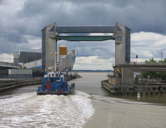
– Tidal Surge Barrier with road and pedestrian swing bridges open

Walking further south along the River Hull, you come to some impressive infrastructure – Myton Bridge, a swing bridge carrying the A63 opened in 1980, and the Tidal Surge Barrier of the same year designed by Oliver Cox.  Cox made his name as a major figure in the housing division of the London County Council’s Architects Department so it was impressive to see the versatility displayed in this later work.

The Deep SN

The Deep, Terry Farrell

Further on is The Deep, designed by Terry Farrell and completed in 2002 – an aquarium and major visitor attraction intended to regenerate this redundant area of former dockland. Nelson Street PC SN

Nelson Street PC III SN

Nelson Street PC II SN

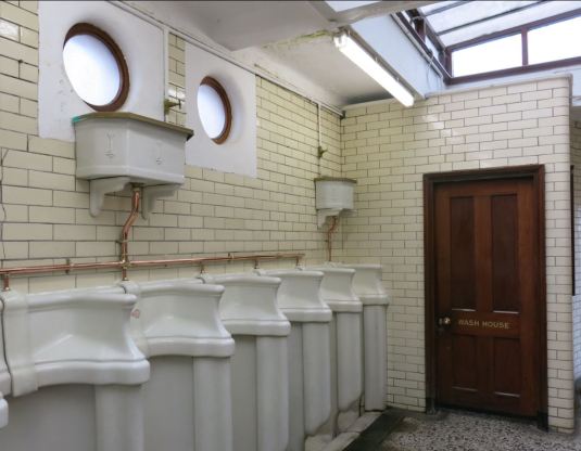
Nelson Street public conveniences

I should really spend more time on that bit of self-consciously showpiece architecture but we’re walking on, west along the Humber, towards Nelson Street and the now celebrated public toilets, Grade II listed (alongside the Tidal Surge Barrier and some other Hull landmarks) a few weeks ago. (3) Opened in 1926, the provision for women as well as men was innovative for the time and offers its own bit of social history as a mark of the greater independence allowed women in the interwar period. Otherwise, just enjoy the quality and beauty of the original Art Nouveau styling and fittings which survive to the present. (4)

Fruit Market SN
– ‘Thieving Harry’s’, Fruit Market

Finally, on this perambulation, you can stop off for some well-earned refreshment in the revitalised Fruit Market area around the corner on the eastern side of Princess Docks. Now rebranded as an arts and cultural quarter, not so long ago it was just what it said it was as some of the surviving shopfronts and signs on Humber Street testify.  The Gibson Bishop building on the corner – once a fruit and vegetable merchant and now Thieving Harry’s café – is another fine example of 1950s’ reconstruction.

All that represents a full day’s visit but, hopefully, you’ll take time to explore the city further.  I’ll conclude with another idiosyncratic, municipally-themed, selection of other highlights.

Holderness Road Library SN
– James Reckitt Public Library, Holderness Road

Heading east along the Holderness Road, you’ll find the James Reckitt Public Library (Reckitt was another local philanthropic Liberal industrialist), designed by Alfred Gelder and opened in 1889 as Hull’s first public library.

Holderness Road Baths SN

East Hull Baths, Holderness Road

Immediately adjacent are the more exuberant East Hull Baths, designed by Joseph H Hirst, then of the City Engineer’s Department, and opened in 1898.

Frederic I Reckitt Havens

Frederick I Reckitt Havens

A little under a mile further east, you reach the edge of the garden village developed before the First World War by Reckitt for the workers of his nearby works.  It’s a beautiful ensemble though now, for the most part, firmly for the more affluent middle classes.  The sweetly-named Frederick I Reckitt Havens, run by Anchor Housing, remain a not-for-profit enclave for elderly persons.

Khyber Pass SN
– The ‘Khyber Pass’ in East Park 

Next is East Park, originally 52 acres, now 120, designed by Borough Engineer Joseph Fox Sharp and opened by the Corporation in 1887. The Khyber Pass folly was constructed, possibly as a project for the local unemployed, between 1885 and 1888.  Not the worst reminder of Britain’s imperial past perhaps.

Beverley Road library II SN
– Beverley Road Baths (c) Richard Croft and made available through a Creative Commons licence

Alternatively head north along the Beverley Road, there are more examples of progressive municipal endeavour – the Stepney Primary School, a Queen Anne-style building of the Hull School Board erected in 1886 and, next door, the Beverley Road Baths, designed by Joseph H Hirst, again, in 1905.

Blitz site SN

The former National Picture Theatre blitz site

Further north along Beverley Road is Britain’s last surviving Second World War Blitz site. The National Picture Theatre, a 1914 cinema, was bombed in 1941 and has remained largely undisturbed since then as an unintended memorial to wartime destruction.  There are now plans to resurrect the listed building as a formal commemoration of the era.

Pearson Park just to the west, originally the People’s Park, opened in 1862 – the city’s first public park – is a superb example of Victorian concern for working-class wellbeing and healthy recreation (even while the latter didn’t generally extend to their profit-making working lives or usually squalid homes).  The poet Philip Larkin’s home, another of the recently listed sites, is an attractive middle-class residence of the 1890s on the northern edge of the park.

Sidmouth Street School SN
– Sidmouth Street School

Larkin was famously chief librarian of Hull University which lies off Cottingham Road to the north.  If you cut across west from Beverley Road, you can take in another of the Hull Board’s fine schools, that on Sidmouth Street, erected 1912 and designed by the industrious Joseph H Hirst.

Court Housing, Sidmouth Street

Court housing, Sidmouth Street

Across the road and on Exmouth Street nearby you’ll see some rare surviving examples of the court housing – short facing terraces built as cul-de-sacs off the main roads – which dominated much of the city’s working-class housing before the First World War.  These are later, and better built, examples from the 1880s.  One of the residents we spoke to was pleased that a couple of people up from London had ventured beyond the city centre.

University of Hull Venn Building SN
– The Venn Building, University of Hull

On to the University and we’ll stretch a point here – though not too far – to make this our final example of municipal investment and innovation. The University was founded in 1925 on the back of a £250,000 donation from Thomas R Ferens and a £150,000 grant from the City Council.  There’s a lot of good architecture to be admired here but I’ll give you the Venn Building of 1928 (‘Neo-Early Georgian’ according to the experts) designed by William Forsyth to capture these interwar origins.

And that’s it. I’ve done a bit more than scratch the surface but all this is only really a taste of what Hull has to offer and a poor substitute for a visit in person.  Above all, it’s a reminder of the huge and important role that local government – as well as a broader civic culture supported by progressive actors – has played in the building and civilising of our cities.

Hull’s deserved status as the UK’s City of Culture in 2017 marks a later iteration of this same endeavour and I hope that the investment and interest it has attracted genuinely improves the lives of local residents as well as entertaining mere visitors such as myself.  I’ll end with a plea that this revival of municipal dreams is an exemplar, not a one-off – a testimony, like so much of what went before, to how a properly resourced and ambitious municipality can improve the lives of its citizens.

Sources

Much of the architectural detail in this post is drawn from the invaluable Hull (Pevsner Architectural Guides, 2010) by David and Susan Neave.

(1) Hull City Council Economic Development and Regeneration Department, Masterplan Guidance, Queens Gardens, Hull (July 2013)

(2) The website British Post Office Buildings and their Architects: an Illustrated Guide has informative description and illustration on Hull’s General Post Office.

(3) For fuller detail on all the new Hull listings, take a look at the Historic England webpage.

(4) Of course, the issue of public conveniences (or present-day inconvenience) isn’t merely a matter of historic or architectural interest. The provision of public toilets was an important part of municipal service in its earlier years and the withdrawal of such provision is a major concern to many sections of the community now.  This is well dealt with, past and present, in a Hull context, in Paul Gibson’s post on Public Toilets in Hull.

Jones the Planner offers a full and more critical perspective on Hull’s post-war planning and architecture in ‘Hull: City of Culture’ (9 February 2014) and, alongside other case studies, in the book Cities of the North (2016).


Share this:

  • Twitter
  • Facebook
  • Email
  • More
  • Tumblr
  • LinkedIn
  • Reddit
  • Pinterest

Like this:

Like Loading...

Municipal Dreams in Hull, Part I: The best laid plans…

22 Tuesday Aug 2017

Posted by Municipal Dreams in Hull, Municipal Trail, Planning

≈ 7 Comments

Tags

Yorkshire

Hull, as I hope you all know, is the UK’s City of Culture for 2017.  You really don’t need an excuse to visit the city but, if that’s an incentive so much the better, because it’s worth it – Hull is one of the friendliest and most interesting places I’ve been to in a long while. What follows – touching on the city’s civic planning and an eclectic mix of some of its municipal highlights (I’ll do some housing stuff in future posts) – can only be an appetiser but I hope it will encourage you to explore the city for yourself.  This first post looks, in particular, at twentieth century plans to reconstruct the city.

Edward I and Charter SN

Edward I and the city’s first borough charter commemorated in the Guildhall

Hull’s been a borough since 1299 and you’ll see some very early town planning in the grid-like pattern of streets off the High Street in the Old Town.  These were added to the original riverbank settlement by Edward I  who wanted the prosperous port as a base for his forays against the Scots and who renamed it formally Kingston upon Hull in the process.

The port – it was the UK’s third largest into the 1950s – and its associated industries expanded massively in the centuries which followed.  By the end of the nineteenth century, the Council – a reformed municipal corporation in 1835 and a county borough from 1888 – desired a civic presence which reflected the town’s importance and prosperity.  In the interwar period, new ambitions emerged to improve the city, a typically squalid product of breakneck Victorian-era urbanisation, as a living and working space for its broader population.  And then the Blitz – which hit Hull harder than any British city outside London – added its own necessity and aspirations to the task of post-war rebuilding.

Abercrombie City Centre before War

The city centre (west-east) just before the Second World War. The newly completed Queen’s Gardens dominate the top of the image; Paragon Station is bottom centre with Jameson Street heading up. (From Lutyens and Abercrombie, Plan)

Abercrombie 1943 RAF Reconnaissace Aerial View

A 1943 RAF reconnaissance shot (north-south) showing city centre bomb damage (From Lutyens and Abercrombie, Plan)

Arriving by rail at Paragon Station brings you to the heart of a new Hull planned by an ambitious Corporation from the 1930s.  Then, the city centre slums which dominated the area were described by Sir Reginald Blomfield, the architectural eminence brought in to oversee the scheme, as an ‘eyesore and menace to health … a disgrace to a progressive city’. He planned to replace the ‘irritating and unsightly jumble’ of older buildings with a neo-Georgian ensemble; the Council itself hoped that Ferensway, as the new thoroughfare was named, would take ‘its place among the famous streets of the world’.  (1)

Brook House SN

Brook Chambers, Ferensway

To be honest, there’s not much to vindicate such hopes now but look north to the junction with Brook Street and you’ll see a vestige of them in Brook Chambers, erected in 1934.  In the event, wartime devastation – almost half the city’s central shops were destroyed – created new urgency and new opportunity to rebuild on a larger scale.

Abercrombie Plan new city centre

The Lutyens and Abercrombie Plan’s grand zonal reimagining of central Hull

Planning for ‘this second refounding of the great Port on the Humber’ began in 1941 and were finalised by 1944, commissioned by the Council from the two foremost town planners of the day, Sir Edwin Lutyens and Professor Patrick Abercrombie. (2)  Lutyens had spent almost twenty years designing New Delhi; Abercrombie drew up influential post-war plans for London and Plymouth amongst others.  Although Lutyens died in January 1944, his imprint on the completed Plan for the City and County of Kingston upon Hull seems strong in the grand Beaux Art scheme devised though it’s a form also favoured by Abercrombie in Plymouth.

More broadly, the Plan incorporated, in the words of Philip N Jones: (3)

the three great themes of post-war planning in Britain – inner city redevelopment; commitment to the social ideal of neighbourhood planning; and the trilogy of Containment – Green Belt – New Town.

A satellite town was planned in Burton Constable eight miles to the east with a narrow Green Belt separating the new settlement from the Hull suburbs.  Neither emerged and the new centre planned, in Abercrombie’s words, as ‘something completely new in Shopping Centres’ –  ‘a highly specialised precinct, free from traffic but adjacent to the central traffic routes’ – also took a very different form from that originally envisaged.

Abercrombie Osborne Street shopping area

The sleek new shopping centre around Osborne Street envisaged in the Lutyens and Abercrombie Plan)

Abercrombie and Lutyens had hoped to create a new shopping centre centred on Osborne Street, adjacent to an expanded and re-formed civic quarter located around Queen’s Gardens. Established business interests and the prevalence of surviving buildings – despite the Blitz – stymied this vision.

A and L Shopping Centre Plan

The Lutyens and Abercrombie plan shows a re-sited main railway station and new shopping centre to the south-west

Chamber of Trade Plan SN

The alternative Chamber of Trade plan keeps a revamped shopping centre to the north. With thanks to Catherine Flinn.

The Chamber of Trade Plan – first mooted in 1947, drawn up by another eminent town planner, WR Davidge, and adopted in modified form in 1954 – was constructed on the foundations of the main existing shopping centre to the north and was seen as far less disruptive.  It incorporated ‘temporary shops’ on Ferensway which survived until 2013.

temp shops Ferensway

Temporary shops on Ferensway. With thanks to Catherine Flinn.

Still, something of Abercrombie’s influence remained, not least in the fact that the plan was overseen by Hull’s new planner, the grandly-named Udolphus Aylmer Coates appointed in 1948, who had been a student of Abercrombie’s at the Department of Civil Design at Liverpool University. (4)

Abercrombie himself thought that the Hull Plan was ‘probably the best report he had been connected with’ but, ironically, as Philip N Jones concludes, ‘no other wartime plan was so ignored or so apparently ineffective’. (5)

House of Fraser II SN

The House of Fraser store on Ferensway and Jameston Street

Nevertheless, the rebuilt streets that emerged offer an impressive testimony to the vision and design aesthetic of post-war reconstruction, most notably in the House of Fraser department store (originally Hammonds) on Ferensway and Jameson Street.  Designed by TP Bennett and Sons and opened in 1950, it’s commended by the new Pevsner for its unusual combination of 1930s and Festival of Britain architectural elements.  Like a number of businesses in the vicinity, it seems to have suffered from that later iteration of our commercial future, the indoor shopping centre, but the building itself remains, to my eyes, strikingly attractive.

Ferensway Jameson Street corner SN

Paragon Square towards Jameson Street

Across the road is a bit of more standard post-war neo-Georgian but, if you look very carefully to the bottom right of the image above, you’ll catch a glimpse of Tony, a local bus driver playing the spoons and giving a one-man band show before starting his shift. He wasn’t busking. As he told us, it was just a way of cheering people up and putting himself in a good frame of mind before work.  He gave us a brilliant introduction to Hull and its people.

Festival House duo SN

Festival House, Jameson Street

Just along Jameson Street is Festival House where a tablet marks it as ‘the first permanent building to arise from the ashes of the centre of the city’ after its wartime destruction.

Phone box SNIf you’ve just arrived, the telephone box in the centre of Jameson Street might be the first of Hull’s famous cream-coloured kiosks you’ll see.  This one looks like a Gilbert Scott’s K6 1930s’ design to me but experts can correct me.   The unusual colour (and lack of crown insignia) isn’t an affectation but a proud reminder that Hull Corporation inaugurated its own municipal telephone system in 1902 which remained free of General Post Office control and privatisation until finally sold off in 1999.  Hull’s telephone and internet services are now operated by Kingston Communications which controversially retains an effective local monopoly.

Walking on, there’s a mix of styles and ages until you come to South Street on the right where you meet Queen’s House, a huge neo-Georgian quadrangle occupying one whole block of the city centre, designed by Kenneth Wakeford and completed in 1952.

Chapel Street Queen's House SN

Queen’s House, Chapel Street

The photograph, of its Chapel Street frontage above, hardly does it justice but it does capture the decline of a commercial district which Abercrombie hoped would restore Hull to its pre-war eminence as a centre serving some 500,000 people.

Three Ships II SN

Alan Boyson’s Three Ships mural

By this time, you will have spotted what should be one of Hull’s most proudly iconic images – Alan Boyson’s Three Ships mural, completed in 1963 and commissioned by the Co-op to celebrate Hull’s fishing heritage.  The stats are impressive enough – it’s an Italian glass mosaic of 4224 foot square slabs, each made up of 225 tiny glass cubes affixed to a 66ft x 64ft concrete screen – but what I love most is the confidence of its bravura statement of local identity.  And I love that it was commissioned by the Co-op, reminding us of a time when that organisation’s consumerism with a conscience (and its ‘divi’ for its working-class members) occupied centre-stage in the drive to build a fairer and more democratic Britain.

Coop mural

The mural in its earlier pomp above the flagship store of the Hull and East Riding Cooperative Society

The Co-op moved on; the premises were taken over by BHS and it went bust in 2016. The building now offers a ‘redevelopment opportunity’ but, whatever happens, please support the campaign to preserve the mural by following @BhsMuralHull on Twitter and signing the petition for listing.

City Hall and Queen Victoria Square SN

The City Hall, Queen Victoria and the exit from the Gents toilets

From here, a right turn down King Edward Street takes you to the heart of civic Hull into Queen Victoria Square, created in 1903 some six years after Hull was granted city status. The 1903 statue of Victoria sits imperiously above some fine public toilets, added in 1923 and retaining their original earthenware stalls, cisterns and cubicles in the Gents.

Unless you’re desperate (and male), they probably won’t be the first thing you notice.  On your right, stands the Edwardian Baroque City Hall, designed by City Architect Joseph H Hirst, opened in 1910.  This was designed as a public hall for concerts, meetings and civic events; on the day we visited it was hosting a graduation ceremony for the University.

Ferens Art Gallery III SN

Ferens Art Gallery, Queen Victoria Square

Across the Square lies the Ferens Art Gallery – a ‘simple restrained classical cube of fine ashlar’ in the words of the latest Pevsner.  It was completed in 1927 following a £50,000 endowment from Thomas R Ferens, a director of Reckitt’s (one of the city’s major firms) and one-time Liberal MP for East Hull.   One of several significant benefactors to the city, Ferens was honoured after his death in 1930 in the naming of Ferensway.

Ferens Art Gallery II SN

An artwork purchased by the Corporation, one of many.

The early support of the Council is clear too among the many fine works on show. The Gallery, free to enter, with some good temporary exhibitions while we were there, is well worth a visit.

Maritime Museum SN

Maritime Museum, Queen Victoria Square

The civic triumvirate is completed by the Maritime Museum facing which was originally built in 1868-71 as the headquarters of the Hull Dock Company – a rare British building by Christopher George Wray who had made his name as an architect for the British Government in Bengal.

Both the dock offices (they became a museum in 1975) and City Hall were scheduled for demolition in the Lutyens and Abercrombie Plan as part of its creation of a new civic quarter – one reason perhaps, despite Abercrobie’s recognition that a ‘clean sheet approach’ would not be welcomed,  why the major part of the Plan went unfulfilled.

Next week’s post continues this tour of Hull, looking at other elements of post-war replanning as well as some of its major municipal accomplishments in the city centre and beyond. And, if you’re new to the blog, I’ve written on the North Hull council estate in an earlier post.

Sources:

(1) Blomfield is quoted in ‘Slums Cleared for New Cityscape’, BBC Legacies, UK History Local to You (ND). The latter quotation is from David and Susan Neave, Hull (Pevsner Architectural Guides, 2010).  Much of the detail which follows is drawn from the same, invaluable, source.

(2) The quotation is from the Preamble to Edwin Lutyens and Patrick Abercrombie, A Plan for the City and County of Kingston upon Hull (A Brown and Sons Ltd., London and Hull, 1945)

(3) Philip N Jones, ‘“…a fairer and nobler City” – Lutyens and Abercrombie’s Plan for the City of Hull 1945’, Planning Perspectives, no 3, volume 13, 1998

(4) RTPI, Rebuilding Hull: the Abercrombie Plan and Beyond (1940s) (2014)

(5) The first quotation comes from Abercrombie himself.  The second and further detail comes from Jones, ‘“…a fairer and nobler City”.

For an unusual but insightful perspective on the Abercrombie Plan for Hull, listen to this track from Christopher Rowe and Ian Clark in ‘Songs for Humberside’ (1971)

My thanks to Catherine Flinn for providing some of the images specified as well as supporting detail.  Her book on post-war city centre reconstruction in Hull, Liverpool and Exeter will be published next year.

Jones the Planner offers a full and more critical perspective on Hull’s post-war planning and architecture in ‘Hull: City of Culture’ (9 February 2014) and, alongside other case studies, in the book Cities of the North (2016).

Share this:

  • Twitter
  • Facebook
  • Email
  • More
  • Tumblr
  • LinkedIn
  • Reddit
  • Pinterest

Like this:

Like Loading...

Growing up on the Speke Estate, Liverpool: a personal perspective

01 Tuesday Aug 2017

Posted by Municipal Dreams in Guest Post, Housing, Liverpool

≈ 51 Comments

Tags

1950s, 1960s, 1970s

One of the most important aspects of this blog has been to give voice to the experience and views of council estate residents, so often ignored, too often maligned. I’m pleased to feature today a post from Tom – in response to posts on Speke on the blog in April and May this year – who describes his own experience of growing up on the Estate and his views on the mistakes that were made in its planning and design. 

Thank you Municipal Dreams for remembering the Liverpool suburb of Speke: a forgotten part of a forgotten city.

I was born in 1951 in, now demolished, Mill Road Maternity Hospital, Liverpool. My parents lived in the Dingle, a wartime bomb-damaged part of Liverpool 8, in a one-room bedsit with an outside toilet. They registered for a new city corporation rental house. For two and a half years my mother attended council surgeries for an update on the request. In 1954 we were allocated a two-bedroom house in Speke, on the city’s southern limit.

Properties in Speke were several orders of magnitude better than accommodation most of its residents had lived in previously. Houses were well built, brick throughout, and had front and back gardens. There were indoor toilets and plumbing for hot and cold water. If you wanted hot water however, you had to light the coal fire an hour before: electric immersion heaters were some time off yet.

Growing up as a child in Speke was idyllic. We lived on the northern perimeter road opposite a farm. Childhood was exploring woodland and playing ‘hide and seek’ in wheat fields. South of Speke was more farmland, more woods and the River Mersey, three miles wide at that point. The river was too polluted to swim in, but it had a sandy shoreline and off in the distance up river, an afternoon’s walk away, Hale lighthouse. What more could a child ask for?

Alderfield Drive SN

Alderfield Drive from Speke Boulevard, February 1972 (c) Tom Speke

Speke Town predates the City of Liverpool, and had been fertile farmland for centuries. The genesis of Speke as a Council Housing Estate dates from the 1930s when Liverpool City Planners became enamoured with the ‘Garden City’ concept as a solution to the problems of a post Industrial Revolution inner city full of overcrowded slums. Plans were made for a ‘self-contained satellite town’.

The desperate need for new housing was exacerbated by Second World War bomb damage and further hastened by the post war ‘baby boom’ population explosion. In the space of a few years (c.1938-1953), Speke mushroomed from a pre-war census of ‘400 souls’ to 25,000 people. In the process, any vestige of old Speke, or its farming history, was bulldozed off the map. Speke Town was buried under the intersection of the newly constructed Speke Boulevard and Speke Hall Avenue.

Close scrutiny of the 1952 photograph, Dunlop’s factory in an earlier post, reveals that large chunks of Speke had still to be built, specifically the central shopping area known as the Parade. From memory, I was nine or ten years old before there were any central shops to go to. There were vans driving around Speke selling groceries, a practice that lasted until the mid 1970s. I have a cine film record.

This ‘Garden City’ idealism never progressed beyond the drawing board. Houses were built and then the building stopped: schools, shops, churches and community centres, all took up to a decade to build. The promise of a ‘self-contained’ Speke went unfulfilled.

The ‘Garden City’ idealism also contained an ill-founded assumption that city people would prefer to live in the country and could be transposed en masse. The ‘self-contained satellite town’ of Speke degenerated into isolated, urban, frontier country, still within the city limits, but a bus ride away from its nearest residential city neighbour.

Rear NW corner SN

Rear south-west corner of Stapleton Avenue and Ganworth Road, 21 November 1973 (c) Liverpool Echo

This ‘open play area’ (above) had been left fallow since the day the flats were built, twenty years previous. Within another twenty years, all the blocks of flats would be gone.

Tenement blocks surrounding open play areas besotted Lancelot Keay, Liverpool City Council Chief Architect responsible for Speke, and a knighthood for his efforts. Watch Sir Lancelot make his case: Liverpool Tenements of the 1930s.

Lancelot Keay was a nineteenth century dinosaur trying to solve a twentieth century problem. Speke residents didn’t share his enthusiasm for living in tenement blocks. By the 1980s, just thirty odd years after they were built, low-rise blocks of flats in Speke lay abandoned and derelict awaiting demolition. Structurally they would have been good for a hundred years, but within less than two generations they were considered not fit for purpose. People didn’t want to live in them. People wanted to live in houses.

All the low-rise blocks of flats in Stapleton Avenue and Ganworth Road (photo above), East Mains, West Mains, Millwood Road, Alderwood Avenue, Central Avenue, Central Way and Conleach Road were demolished and replaced by houses with gardens. Testament that ‘tenement blocks surrounding open play areas’ was a failure.

In the mid ’70s I made a cine film record of Speke. It was an Art School rant intended to show the estate in a less than favourable light: not a difficult task. The irony is that it has become historically significant, as less than half of what was filmed still exists.

Ganworth Road SN

Ganworth Road looking south, October 1973 (c) Tom Speke

Above is a street view of Ganworth Road with Speke’s signature three storey blocks of flats either side. It may look odd, from a 2017 perspective, to see two children and a toddler wandering around unaccompanied, but it was nothing out of the ordinary in the 1960s and 1970s. The legacy of living in flats was that children had no back gardens to play in, and resorted to playing in the streets.

Speke Castle NW

A child admires ‘Speke Castle’, 13 November 1974 (c) Liverpool Echo

This concrete eyesore, above, is a 1960s’ interpretation of a children’s play area. By 1974 it was condemned by the National Playing Fields Association as grotesquely dangerous and only fit for demolition. The low-rise blocks of flats behind (West Mains) would soon join it awaiting demolition.

The 1950s and 1960s presented a paradox for Liverpool. The ring of housing estates that surrounded the city, of which Speke was but one, were overflowing with children, yet the population of Liverpool had been in steady decline since the 1930s, and continued to decline for the rest of the century. The inner city was being rehoused further and further afield, outside of the city. The population of Liverpool went from a 1931 peak of 855,688 to a 2001 census of 439,473.  (2)

The ‘baby boom’ years were followed by a shift to smaller families. This left a problem for Speke: what to do with all the three storey ‘large family’ houses, of which there were many. After abandonment, these were reduced to two storeys.

The section of Speke in the aerial shot (below) was built in the 1950s, but I doubt if anyone younger than forty can remember it as such. Half of what you see is no more. The white roofed rectangular buildings, centre, was All Hallows Secondary School, boys and girls, now All Hallows Drive houses. The school was demolished, not enough students.

The open space two blocks above the school was Speke Park, now Morrison’s shopping precinct. The retail hub of Speke shifted from the centre to its edge to access Speke Boulevard, top right diagonal. Fords [Jaguar/Land Rover] off picture, right.

To the left of Speke Park is the ‘open play area’ behind the flats, in the top photograph. The main road in the picture, top to bottom, is Stapleton Avenue / Alder Wood Avenue which runs east-west. Just visible at bottom right of the picture is Eastern Avenue. Check Google Maps and see what little remains.

North Central Speke SN

North central Speke estate, c.1963, looking west (c) Lancashire Records Office, Preston

For ‘Beatles’ cognoscenti, the street second from the bottom, on the left, is Ardwick Road, the McCartneys’ second residence in Speke (1950-1955). Half way up on the left is Upton Green, surrounded by three storey blocks of flats, and home to the Harrisons (1950-1962).

On 20th December, 1958, on the occasion of George’s brother Harry’s wedding reception, 25 Upton Green, Speke, was the venue of a pre-Beatles Quarrymen performance with John Lennon, Paul McCartney and George Harrison – drummer, if any, not known. (2)

George Harrison and Paul McCartney spent most of their formative years in the Liverpool suburb of Speke (George 12 years, Paul 9 years), but you have to look hard in the plethora of biographies to find any mention of their early childhood in Speke. Phoney Beatle mania has produced two ‘Caverns’ in Mathew Street, but ‘Beatles’ tour buses don’t go anywhere near Speke.

In the early 1960s, the Ford Motor Company car plant [now Jaguar/Land Rover] replaced the farm on the northern side of Speke. Speke Boulevard, forever known to my generation as ‘Ford’s Road’, was extended to run between the car factory and the estate, for the full length of Speke and beyond. To compound Speke’s isolation, this arterial road prohibited pedestrians for five miles or so, all the way to Widnes.

Eastern Avenue bus SN

Eastern Avenue bus terminus from Speke Boulevard, February 1972. The sign reads ‘Any Person found damaging this fence will be prosecuted’ (c) Tom Speke

One of the consequences of this pedestrian prohibited road was that it separated the factory from the workers arriving by bus at the Eastern Avenue bus terminus. There was an underpass 200 yards away, but for whatever reason, people insisted on making their way through the fence to cross the road. This conflict persisted for thirty odd years until the terminus relocated to Morrison’s at the new shopping precinct. Progressively stronger fences were built with ever more ingenious ways found to get through them. It would have been cheaper to build a footbridge. I viewed this perennial conflict as individual protest against imposed isolation.

When I visit Speke, the difference I find most striking between now and even up to the 1980s, is not the missing or changed dwellings, but the amount of trees there are. Driving along Speke Boulevard is like driving through woodland. Trees now obscure all the sight lines of my childhood memories. Belatedly, the city has made amends for wiping a thousand years of history off the face of the earth in Speke’s construction. I cannot see, or remember there being, a single mature tree in the 1963 aerial photograph of Speke.

The 1960s’ Speke of my teenage years was a depressingly bleak, isolated, rectangular Gulag, devoid of any sense of history or community, built to house factory fodder. By the time I was sixteen, my life’s objective was to get out of Speke. Three years later I went away to Art School, never to return. I did visit, but never lived. My Mother, give her a medal, is still there: Speke resident for 63 years and counting. (RIP Father, 2010).

Speke as a Housing Estate did have two redeeming features:

  • All the properties were solidly built with brick throughout.
  • The estate was built before the advent of the ubiquitous high-rise tower blocks that blighted other estates.

The failings however were legion, chief among them was that it didn’t comply with the house buyers’ mantra of ‘location, location, location’: Speke Estate was built in the wrong place. Its isolation was, and remains, its handicap.

If there are Town Planners out there who still adhere to ‘self-contained satellite town’ thinking, I will happily maroon them on the eastern edge of Speke, without a car, to experience what isolation feels like.

Speke’s contribution to town planning dogma is a nail in the coffin of the ‘Garden City’ concept. Speke was designed as a solution to a problem, but resulted in generating its own problems. Speke planners may not have anticipated the changing shift in family sizes, but they are guilty of not ensuring that Speke would become a solution.

Speke could never develop as a community because Speke was never self-contained. If you wanted to do anything, you had to find somewhere else that catered for your interest.

The founding vision of Speke as a township ‘planned to accommodate all classes of the community’ was as delusional as its ‘self-contained’ status. Speke, and all the other post war housing estates around Liverpool, were not communities, they were overspill.

In the absence of any community identity, people from Speke, and all the other Liverpool estates, were perceived differently. In a time of full employment, people living on estates were not accorded the ‘working class’ designation, but were thought of in the then unused demographic of ‘underclass’. Like the estates themselves geographically, people from the estates were regarded as ‘peripheral’, not part of the mainstream. You came from ‘an estate’. It didn’t matter which one, we were all tarnished with the same brush. I lived all my teenage years with this, and left at the first opportunity.

My parents tried for years to get out of Speke, but eventually resigned to staying when they were able to buy their house. My siblings left Speke, and Liverpool. I took it a stage further and emigrated.

I still talk ‘Scouse’. My accent was set in concrete by the age of six, and I have yet to find an alternative that I would want to emulate. I still follow Liverpool FC from a distance, but I could never live there again. Morrison’s precinct in Speke, and the Liverpool ONE complex, are commendable and possible turning point improvements. The irreconcilable is remembering the fifty years it took to get to there.

Orient II SN

The Orient public house, Eastern Avenue (December 2016) and bar (November 2013) (c) Tom Speke

The Orient is the last remaining pub in Speke, and worth a visit if just to see a bar dedicated to both Liverpool and Everton football clubs. It is difficult to say how much longer The Orient can last. For decades, supermarkets in Britain, Morrison’s included, have been underpricing pubs out of existence.

Speke Estate is suffering the malaise experienced by small towns after a bypass is built. The fulcrum relocates: people leave, schools close, pubs shut, churches downsize. Speke in the 21st century has half the population it had in the 1950s. St. Christopher’s Church (capacity 1,000) has the distinction of being built and demolished in a single lifetime. Schools are torn down as the numbers of children plummet. I had intended to show my film and photographs to the students at Parkland’s School, but it closed, only twelve years after it opened. Depending on whom you ask, it was either falling intake or falling standards. Either way, Speke no longer has a secondary school.

Speke’s fate was sealed on the drawing board: it was designed to have a bypass. No one ever goes through Speke: making a brief detour off Speke Boulevard to shop in Morrison’s doesn’t count. The problem was there from its inception. Speke, as the city planners envisioned it, never should have been built.

tomspeke@yahoo.ca

Sources

(1) A Vision of Britain through Time: Liverpool population

(2) Gratitude to the Quarrymen website for information.


Share this:

  • Twitter
  • Facebook
  • Email
  • More
  • Tumblr
  • LinkedIn
  • Reddit
  • Pinterest

Like this:

Like Loading...

Enter your email address to follow this blog and receive notifications of new posts by email.

Join 22,781 other subscribers

Archives

  • March 2023
  • February 2023
  • January 2023
  • December 2022
  • November 2022
  • September 2022
  • August 2022
  • July 2022
  • June 2022
  • February 2022
  • December 2021
  • September 2021
  • August 2021
  • May 2021
  • April 2021
  • March 2021
  • February 2021
  • January 2021
  • December 2020
  • November 2020
  • October 2020
  • September 2020
  • August 2020
  • July 2020
  • June 2020
  • May 2020
  • April 2020
  • March 2020
  • February 2020
  • January 2020
  • December 2019
  • November 2019
  • October 2019
  • September 2019
  • August 2019
  • July 2019
  • June 2019
  • April 2019
  • March 2019
  • February 2019
  • January 2019
  • December 2018
  • October 2018
  • September 2018
  • August 2018
  • July 2018
  • June 2018
  • May 2018
  • April 2018
  • March 2018
  • February 2018
  • January 2018
  • December 2017
  • November 2017
  • October 2017
  • September 2017
  • August 2017
  • July 2017
  • June 2017
  • May 2017
  • April 2017
  • March 2017
  • February 2017
  • January 2017
  • December 2016
  • November 2016
  • October 2016
  • September 2016
  • August 2016
  • July 2016
  • June 2016
  • May 2016
  • April 2016
  • March 2016
  • February 2016
  • January 2016
  • December 2015
  • November 2015
  • October 2015
  • September 2015
  • August 2015
  • July 2015
  • June 2015
  • May 2015
  • April 2015
  • March 2015
  • February 2015
  • January 2015
  • December 2014
  • November 2014
  • October 2014
  • September 2014
  • August 2014
  • July 2014
  • June 2014
  • May 2014
  • April 2014
  • March 2014
  • February 2014
  • January 2014
  • December 2013
  • November 2013
  • October 2013
  • September 2013
  • August 2013
  • July 2013
  • June 2013
  • May 2013
  • April 2013
  • March 2013
  • February 2013
  • January 2013

Blogs I Follow

  • Coming Home
  • Magistraal
  • seized by death and prisoners made
  • Women's Work in Rural England, 1500-1700
  • A London Inheritance
  • London's Housing Struggles
  • architectsforsocialhousing
  • The Historic England Blog
  • The GDR Objectified
  • The London Column
  • A Sense of Place
  • distinctly black country
  • Suburban Citizen
  • Mapping Urban Form and Society
  • Red Brick
  • Single Aspect's Blog
  • History & Social Action News and Events
  • The Charnel-House
  • Musings
  • Council Homes Chat

Blog at WordPress.com.

Coming Home

Magistraal

seized by death and prisoners made

stories from our past.

Women's Work in Rural England, 1500-1700

Leverhulme Funded Project at University of Exeter: Adopting a New Methodological Approach to Early Modern Women's Work

A London Inheritance

A Private History of a Public City

London's Housing Struggles

acting as a knowledge broker towards London's housing crisis, going on a search for alternatives, get in touch londonshousing@gmail.com

architectsforsocialhousing

Architects for Social Housing (ASH) has been set up to respond architecturally to London’s housing crisis.

The Historic England Blog

The GDR Objectified

A private collection of ephemera from or related to the German Democratic Republic

The London Column

Reports from the life of a city, from 1951 to now, compiled by David Secombe

A Sense of Place

Better Lives in Better Places

distinctly black country

a network for understanding yesterday's landscape today

Suburban Citizen

A fine WordPress.com site

Mapping Urban Form and Society

Red Brick

The place for progressive housing policy debate.

Single Aspect's Blog

because I care about public housing and hate single aspect flats

History & Social Action News and Events

News and events related to history and social action, especially in Battersea, Croydon, Kennington, Vauxhall & Wandsworth

The Charnel-House

From Bauhaus to Beinhaus

Musings

of a social historian

Council Homes Chat

Busting myths about Council Housing by providing a platform for people's stories/experiences #CouncilHomesChat #SocialHousing

Privacy & Cookies: This site uses cookies. By continuing to use this website, you agree to their use.
To find out more, including how to control cookies, see here: Cookie Policy
  • Follow Following
    • Municipal Dreams
    • Join 2,058 other followers
    • Already have a WordPress.com account? Log in now.
    • Municipal Dreams
    • Customize
    • Follow Following
    • Sign up
    • Log in
    • Report this content
    • View site in Reader
    • Manage subscriptions
    • Collapse this bar
 

Loading Comments...
 

    %d bloggers like this: