Kielder Village, Northumberland: Thomas Sharp and a ‘harbinger of a rural revolution’?

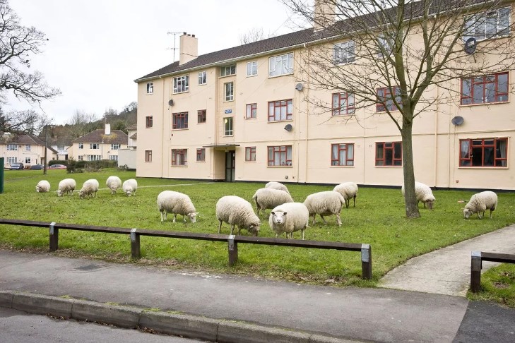
Kielder in Northumberland, population 194, is by most accounts the most remote village in England. The nearest cash machine is 18 miles away in Bellingham and the nearest shopping centre, Hexham, is a 53-minute drive – there are no public transport options. On the other hand, residents enjoy a deeply rural location and the 580 square miles of star-lit sky known as the Northumberland International Dark Sky Park.

To some of us, its history and design will be of even greater interest – the village provides a small blueprint of the ideals of one of Britain’s most influential planners, Thomas Sharp, and a cameo of the forces and dynamics that shaped the wider nation in the twentieth century after two world wars.

An extract of the 1899 Ordnance Survey map of the area, with thanks to the National Library of Scotland

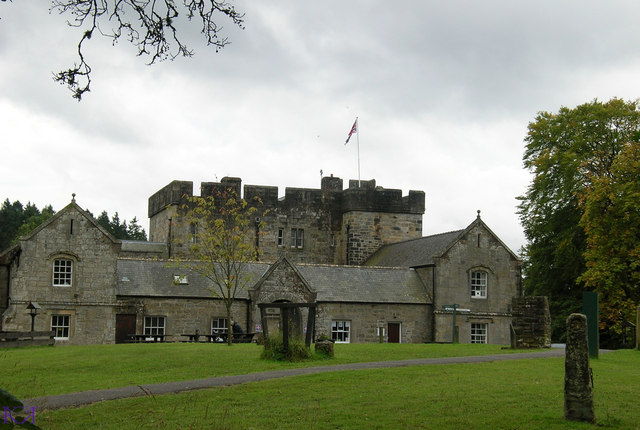
In the nineteenth century, the area seemed, in British terms, a wilderness – predominantly open moorland with some low-intensity sheep grazing – but one that provided excellent sport for the local landowner, the Duke of Northumberland. His shooting box – a misleadingly modest term for the rather large mock-Gothic castle built in 1775 – was located in Kielder.

A map of the Border Counties Railway © the Disused Stations website

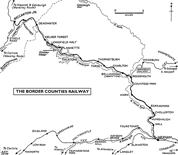
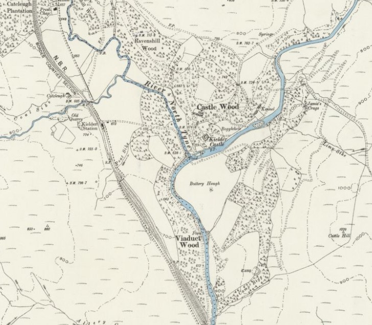
And, then, somewhat surprisingly but reflecting the ambition and competition of the age, Kielder acquired a railway station in 1862 when the Border Counties Railway drove a line up the North Tyne Valley from Hexham to join the Scottish rail network at Riccarton Junction.

Kielder Castle © Kerry Rourke and made available through a Creative Commons licence

The First World War had a greater impact. By the turn of the century, forests and woodland accounted for just four percent of Britain’s land surface. As a trading nation, we’d been happy to import most of our timber but the threat of blockade and the needs of total war concentrated minds. In July 1916, Sir Francis Acland was asked ‘to consider and report upon the best means of conserving and developing the woodland resources of the United Kingdom’. The 1919 Forestry Act that established the Forestry Commission with powers to acquire and plant land and promote timber supply and forest industries was the result.

The Commission bought its first land at Kielder from the Duke of Northumberland in 1925. The death of the eighth duke in 1930 and incumbent death duties forced the sale two years later of a further 47,000 acres (over 19,000 hectares).  The initial planting of what became, at 235 square miles, England’s largest forest proceeded over the next ten to fifteen years. Some early commentators were critical of the Commission’s plans: (1)

whole sections of the country are being turned into tree slums – places where overcrowding is taking place without imaginative design – thus creating ugly landscapes.

Its decision to consult the Council for the Preservation of Rural England was deemed too little, too late. Such criticisms were to persist, of course. The coniferous Sitka spruce, an import from North America, covers about 75 percent of the planted area of Kielder Forest.

1930s housing on Castle Drive

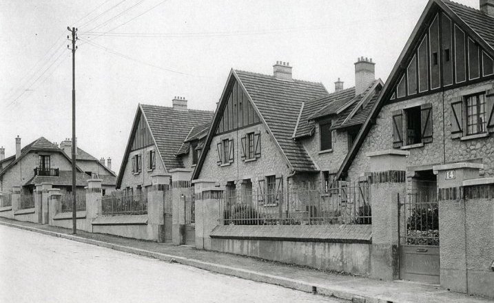
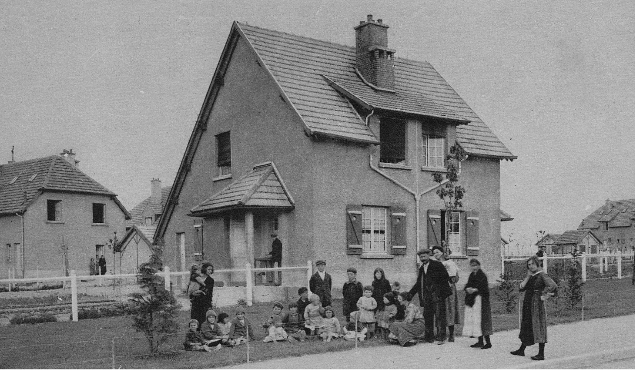
The first Forestry Commission housing at Kielder was built from 1935 – pebble-dashed and painted semi-detached and terraced homes in Castle Drive (next to the station) which wouldn’t have looked out of place in a pleasant garden suburb. Most houses remained scattered through the forest where they were needed for the early detection of fires and rapid fire-fighting.

These were certainly superior conditions to those enjoyed by the unemployed men of the north-east who, desiring to ‘avail themselves of the opportunity for training and reconditioning’, found themselves placed in summer camps in Kielder. By the mid-30s, 200-250 men were accommodated in a camp of temporary hutments in Kielder, others were dispersed under canvas. This was part of the Ministry of Labour’s policy towards the so-called ‘distressed areas’, four areas suffering particularly high unemployment during the Great Depression; Tyneside was one (the others being South Wales, Cumberland and central Scotland). The Ministry was at pains to emphasise that the Government was not engaged in the business of job creation; ‘the men will receive a small allowance, unemployment pay being set off against the costs of their maintenance’. (2)  

In the event, a second world war provided employment for Britain’s jobless. It also strengthened the economic case for the development of Kielder Forest; a case made all the sharper by the balance of payments crisis that hit the country in 1947. At the same time, the hopes and expectations engendered by wartime struggle and eventual victory brought new ideals as to how the British working class and Kielder’s workers should be treated.  

The economic arguments were well captured in a local press article headlined ‘Northumberland Forest Will Save Dollars’ as it described how the Forestry Commission’s plans for Kielder: (3)

should save us 46 million dollars-worth of timber exports in the next twenty years. It should also give employment to 2,000 lumberjacks as well as thousands more engaged in the timber industry.

It was a sign of the times that of the 350-strong workforce currently employed, some 60 to 70 were workers transferred voluntarily from displaced persons camps in Europe.

Something far better, however, was planned for the future. To some, thoroughly briefed by the Commission, trees were ‘the Harbingers of a Rural Revolution’.  Eight new villages were planned for the Forest, Kielder itself would be the largest – ‘new village communities of estate workers, adequately and compactly housed, and enjoying a high standard of local amenities’. Nowadays we might question the enthusiasm of the reporter but, at a time of genuine belief in a better future, perhaps he or she was right to conclude:

There can be no doubt that Britain’s new efforts will enrich the countryside physically, economically and socially. Those who are carrying out the policy are not merely silvicultural experts but men of imagination, fired with the ideal of balanced, prosperous and happy rural communities.

Thomas Sharp

Thomas Sharp, one of the foremost town planners of the day, was the person appointed by the Forestry Commission in 1946 to implement this vision. Sharp had been born to a working-class family in County Durham. Apprenticed to a surveyor, he made his name as a town planner with his first book Town and Countryside, published in 1932, and, in 1940, Town Planning, a Pelican paperback that sold 250,000 copies. During the war, he was seconded to the Ministry of Works and Buildings as Secretary to the Scott Committee on Land Utilisation in Rural Areas.

Sharp was the principal drafter of its 1943 Report and among its recommendations – tellingly for his future work – was the following: (5)

New villages and extensions of villages should be planned, and should as far as possible be of a compact and closely knit character: no attempt should be made to recreate in new villages the irregularity and ‘quaintness’ of old ones.

The Report also suggested that terraced housing made for the best form of village housing.

In 1946, Sharp published Anatomy of the Village in which he identified five historic village types (reflecting differing patterns of development) but concluded that most villages, especially in the north of England, were nucleated, that is built around a distinct centre. This became his personal preference.

At the same time and as he looked to the future, he eschewed pastoral nostalgia:

The rural feeling of the village does not depend on any of those things that are popularly associated with it, flowering gardens, irregular, informal, and quaint buildings, and so on. It seems to depend on much smaller and more subtle things, upon a certain modesty, a certain lack of the smooth, mechanical finish of the town, and above all upon the harmony of the material of its buildings with the countryside.

Thomas Sharp’s drawing of a projected village square in Kielder from Architect & Building News, 15 April 1949

This allowed him to advocate planning and, in effect, what John Pendlebury has called an ‘a kind-of ordered informality’.  Sharp wrote in Anatomy that:

The new villages … should be clean straightforward streets of honest modern buildings, grouped in a square or a series of squares or similar formations, round a simple green or gravelled space where maybe the telephone box may take the place of the village pump.

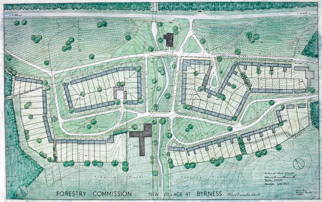
In all this, Sharp seemed the perfect person to design the eight new villages proposed by the Forestry Commission. As Sharp himself wrote, the intention was that ‘every village shall be of a size to be able to provide a reasonably satisfactory social life of its own, and shall be sufficiently large to support a primary school and other necessary village institutions’. Six of the eight were to have a population of 350 or less but Kielder (and one other) was planned to contain 220 houses accommodating around 800 people. (6)

Sharp acknowledged the objections that the new settlements would be little more than ‘“company villages” and may develop the unpleasant characteristics that such villages had in the past’ but he was confident that:

with the strong trades unionism of to-day that would be nearly impossible, even if (an extremely unlikely event) a public body such as the Forestry Commission did tend to develop the characteristics of nineteenth-century captains of industry.

Sharp’s plan for the new Kielder village from Architect & Building News, 15 April 19492

As construction began in the early to mid-1950s, Sharp returned to his key themes: (7)

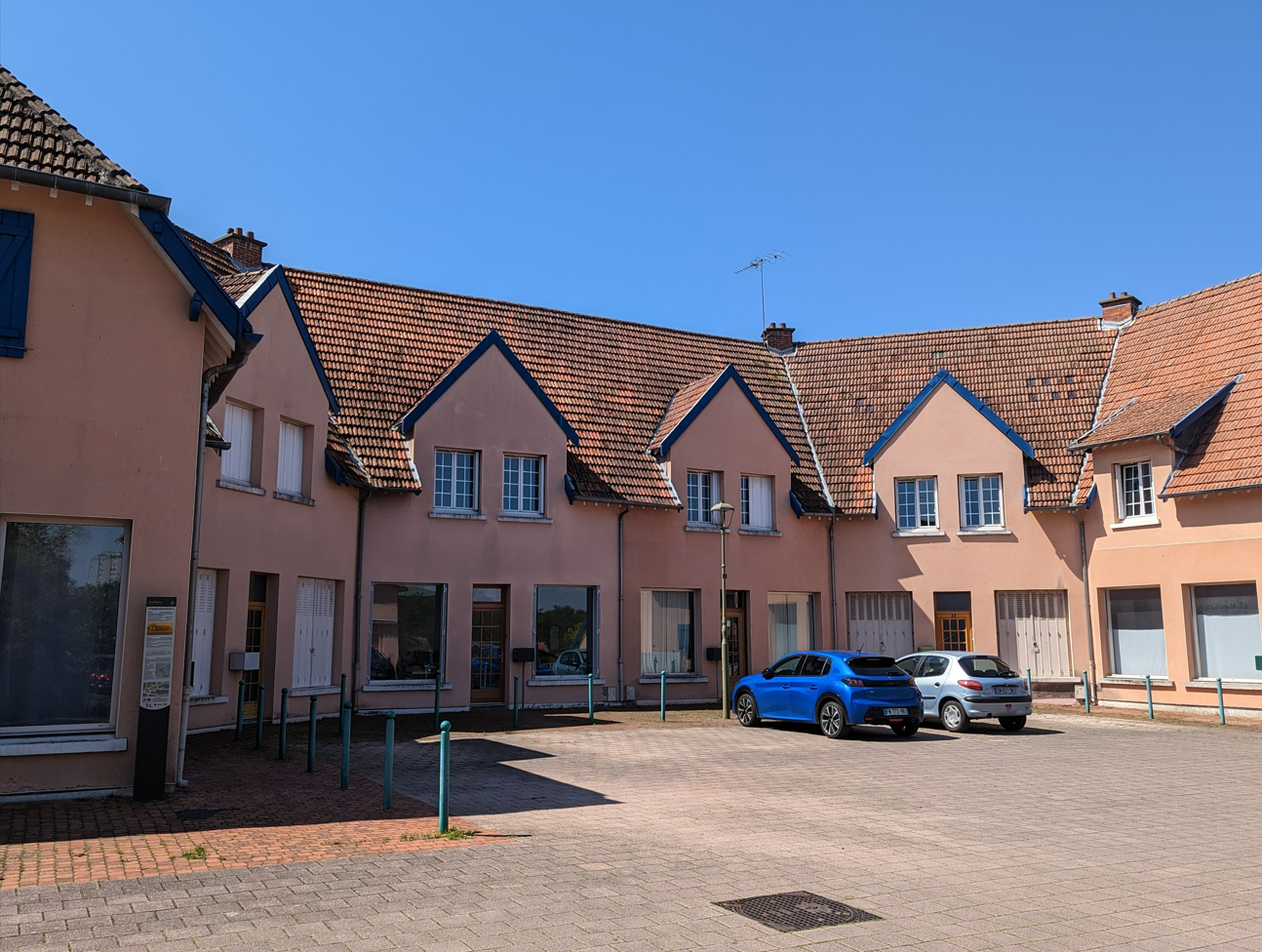
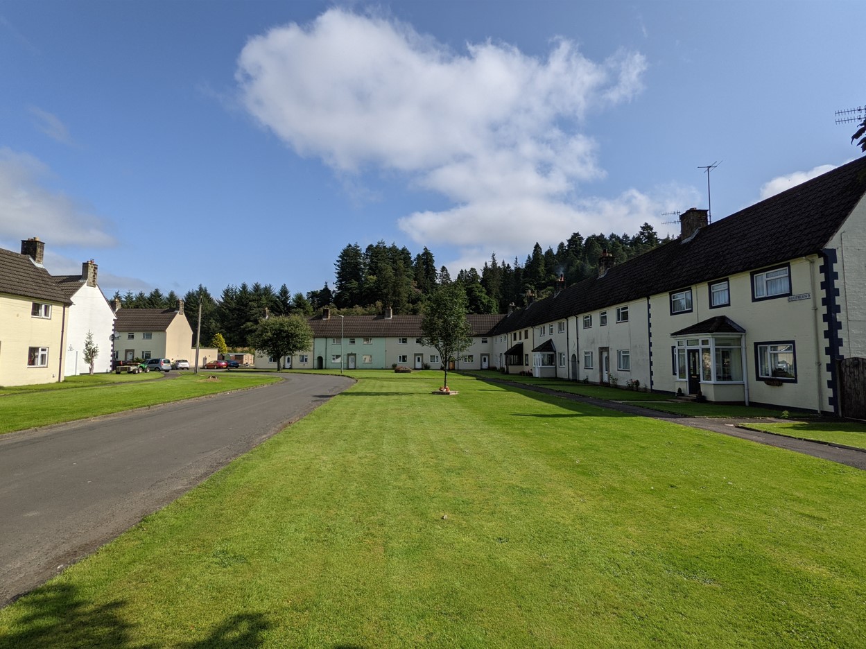
In designing the lay-out plans, the aim has been to try to capture for each place the character of a true village as distinct from a mere housing estate or a bit of suburbia dropped down miles away from a town. Each village will have a central square or place and most of the houses will face on to enclosed greens that will be given freely-designed forms, as distinct from either deliberately-created formality or carefully-calculated informality.

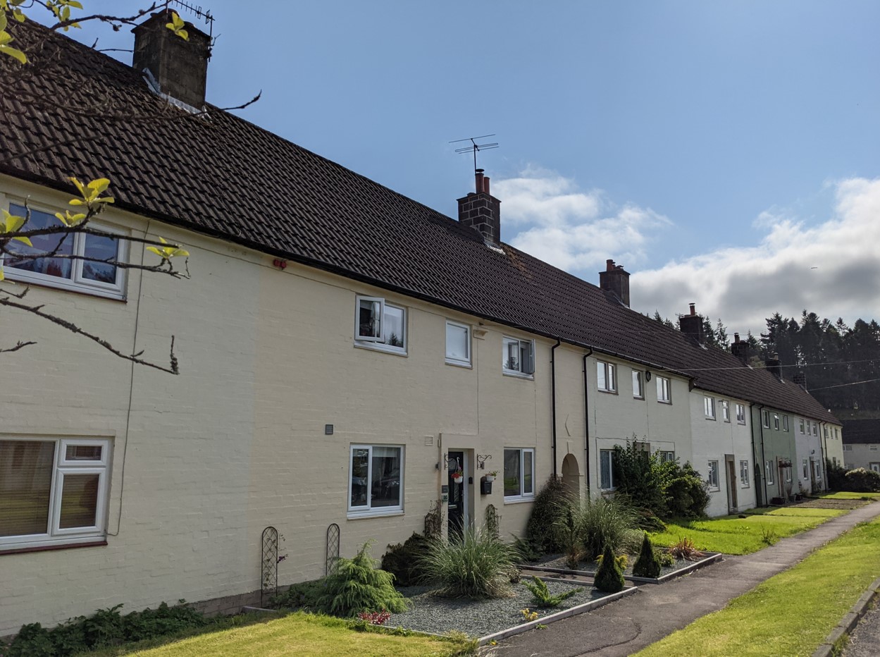
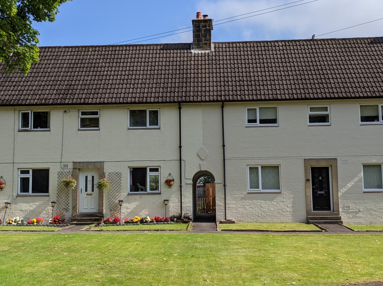
He reiterated his support for terraced houses ‘because they will contribute more to village character that way and because they will thus gain mutual snugness against the weather of the exposed region’. [It’s interesting to note that Tayler and Green, in the superb range of council they designed for South Loddon Rural District Council from the late 1940s, also advocated terraced housing for its ‘advantages of economy, warmth and restful appearance in the landscape’. (8)]

But there was to be no attempt to ‘make them traditional in appearance’.  The local dark stone was unsuited to contemporary construction and to the appearance of new villages set amidst dark coniferous forest. Colour-washed housing ensured ‘the villages will not only be light-looking in themselves, they will also enliven the far-stretching monotones of the forests’. (9)

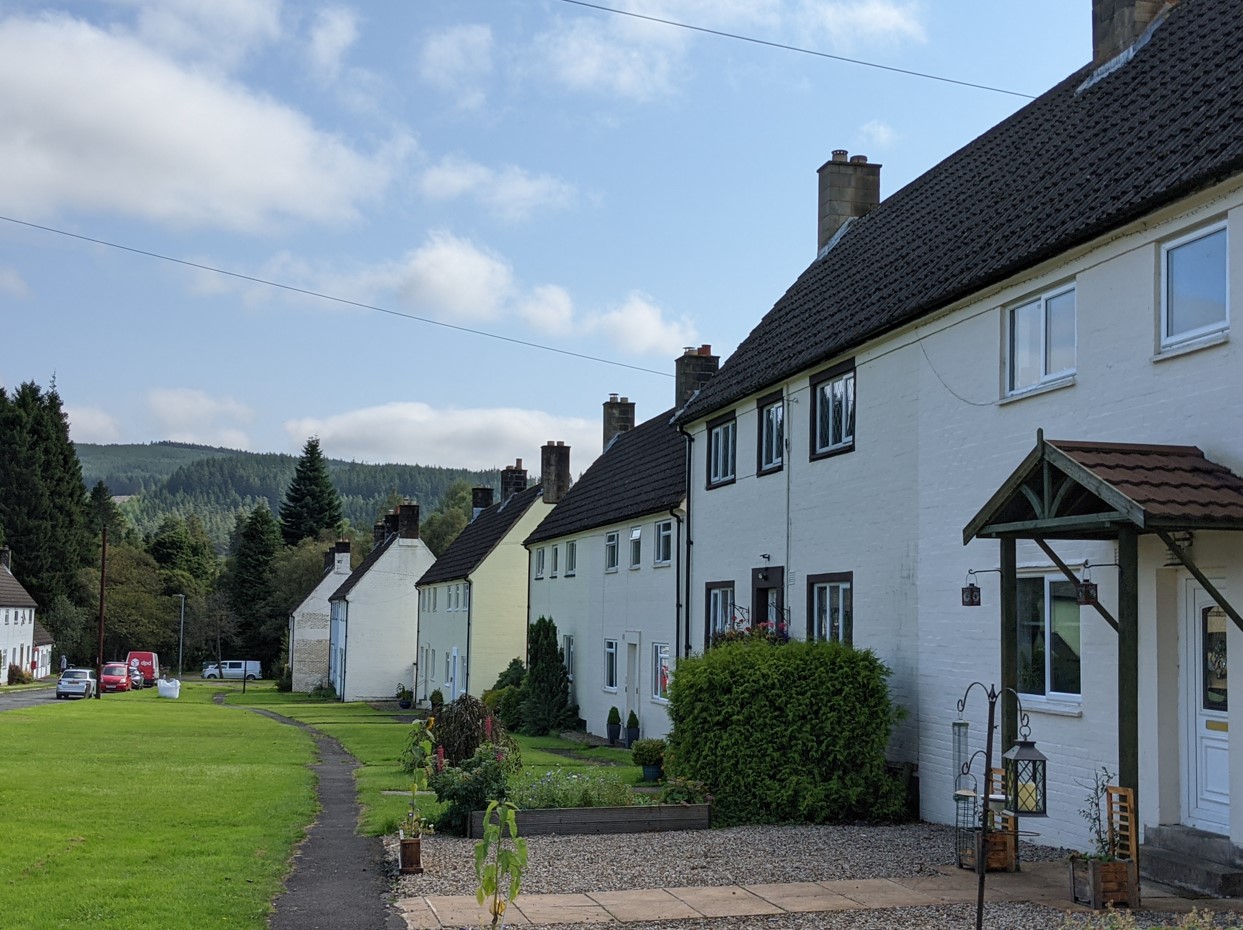
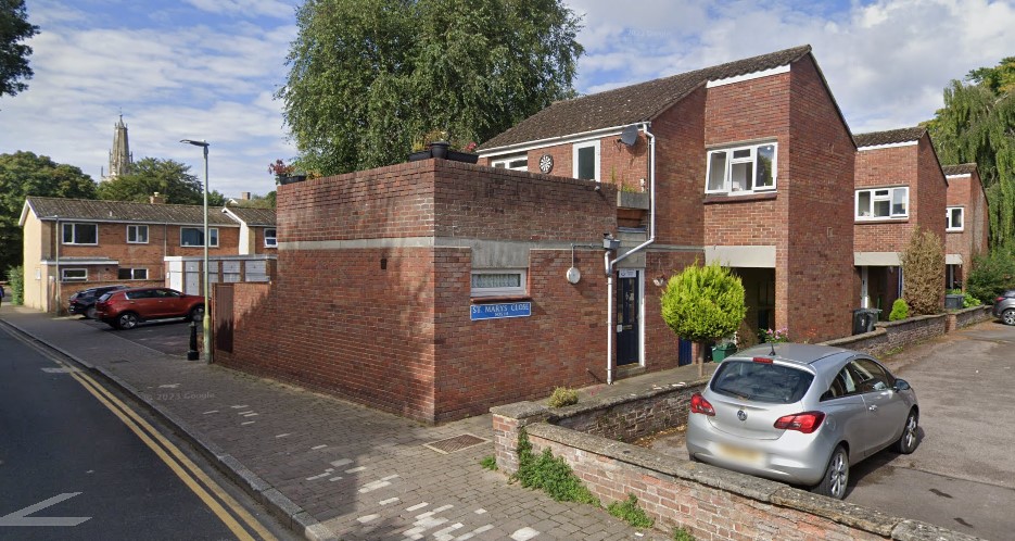
At Kielder itself, Sharp resisted ideas that the bulk of the new village should be built as an extension of the existing housing centred on Castle Drive. Instead, he favoured a new site at Butteryhaugh about 500 metres to the south-east. (Technically, it might be considered a separate village but is generally treated as part of Kielder Village.) The 1949 article in Architect & Building News outlined his ambitions. (10)

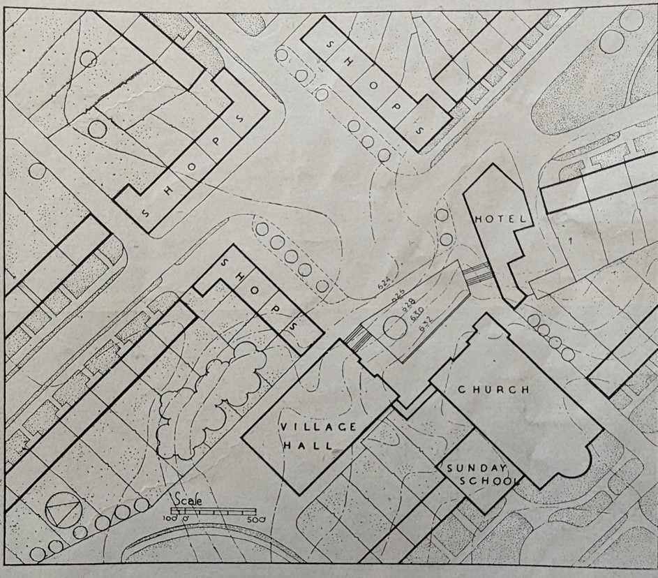
The layout has been designed to secure good village character. Since this village will act as a kind of local capital, a fairly substantial village centre has been planned to contain a dozen shops, a couple of pubs, as well as the church and a village hall where films can be shown once or twice a week.

A plan of the projected village centre in Kielder from from Architect & Building News, 15 April 1949

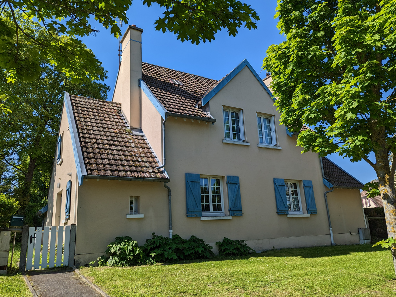
In May 1952, Kielder village was officially opened by the chairman of the Forestry Commission, Roy Robinson, officially ennobled in 1947 as Lord Robinson of Kielder Forest. As the village developed, Sharp was disappointed that it was the Ministry of Works, rather than the Forestry Commission, that oversaw the housebuilding and disliked its bureaucratic insistence that all roads should have standard concrete curbs. He was happy, however, with the houses themselves (designed by Robert Mauchlen of the respected Newcastle architectural practice, Mauchlen & Weightman) which did at least conform closely to the principles he had set out.

Kielder village, South End

In time, Sharp’s frustrations with the Forestry Commission itself grew. He was angry at their refusal to build and support the community infrastructure – the pubs, clubs and shops – that were integral to his vision. He resented the fact, irony of ironies, that the Commission, after much pressure, only provided £5 or so per village to support amenity tree planting. He resigned his post and later declared Commission ‘the worst client he had’. (In fairness, Sharp had somewhat of a record of falling out with those who employed him.) (11)

South End, showing some later intrusion into Sharp’s open green verges

Even some of the new residents annoyed him:

some of the tenants have demanded the right to dig up the village greens for rose gardens and flower and vegetable patches, and have brought in the local M.P. to support them in their fight against the tyranny of planners.  

That local MP, Rupert Speir, whose Hexham constituency took in Kielder, emerged as one of the fiercest critics of the Forestry Commission’s performance in the Kielder villages. In 1954, Speir complained in parliament that they lacked ‘a shop, a club, a “pub,” a hall, a telephone kiosk or a stamp machine. I believe that there is not even a letter box’. He was similarly critical of the housing at Kielder: ‘It would be hard to imagine anything more like a dockyard settlement, or anything more grey and forbidding’. The last straw for the Forestry Commission workers, paid the minimum agricultural wage but paying full rent and rates (80 pence and 20p respectively weekly) but receiving minimal services was that the Commission required them to pay full price for their Christmas trees cut from the approximately 120 million in the forest. (13)

Some of this was unfair, as the junior minister responding pointed out, given that the villages were so new but Speir returned, equally caustically, to the fray six years later: (14)

at Kielder, there are … well over 100 houses, with a population of 400, and yet there is not one single general shop in that village. The nearest shops are miles away. There is no inn, and the village hall is nothing more than a tin shack.

And he still thought – he repeated the phrase – that the new houses looked ‘like nothing more than a dockyard settlement’. The Conservative MP felt that, if Commission employees had withdrawn their labour, ‘a strike would have been fully justified’.

Kielder village, South Waterside

Others, looking back, were also critical – or at least very aware – of the power of the Commission: (15)

It was a Forestry Commission village, and forestry ruled the roost and everything was done to their beck and call … it was their land, it was their houses, it was their road, it wasn’t council run roads, it belonged to the Forestry Commission … they cleaned the streets, snow and what have you … they owned the houses, they owned all business, the little shop, … the little café, they owned all the books, … all revolved around the Forestry Commission.

If it wasn’t, negatively, a company town, it was certainly what the sociologists would call an occupational community.

Sharp’s plan for Byrness
Byrness, an image taken from the community’s Facebook page

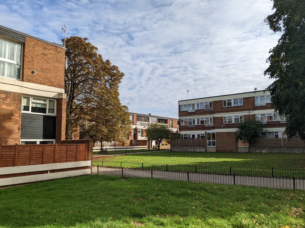
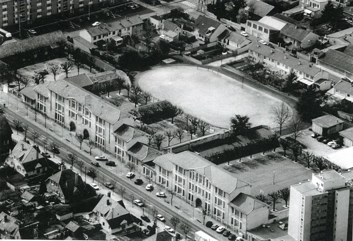
Nowadays, in contrast to Speir, I think most observers would agree now that the village’s homes are attractive in just the ways that Sharp aspired to. The key reality was that Kielder’s workforce – as mechanisation took off and communications improved – simply didn’t expand in the way that had been envisaged. Of the three villages built of the eight originally planned, Kielder is about a third of its planned size, Stonehaugh and Byrness about half. As you might expect, Kielder’s 180 houses are now privately owned.

With hindsight (but perhaps with a touch more realism), Sharp’s notion that the village could sustain ‘a dozen shops, a couple of pubs’ seems fanciful to say the least – a harking back to pre-industrial villages rather than a glimpse of a feasible future.

The school and library

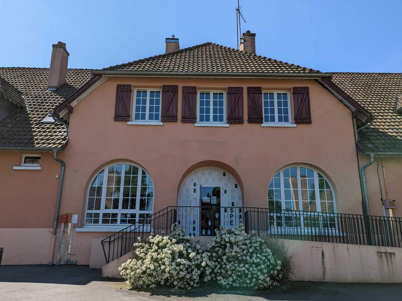
Kielder’s new primary school, built to accommodate 100 pupils, had over 80 when opened. The school roll fell to two at its lowest but had recovered to twelve in 2019 when inspected by Ofsted (and rated ‘Outstanding’). The school buildings includes community rooms and a library. A village shop and post office survives on Castle Drive. And there is a pub, the Angler’s Arms situated near the Castle which is itself now a busy visitor centre for Kielder Forest.

Kielder Post Office and Stores in 2011 © Les Hull and made available through a Creative Commons licence

The latter mark the major change to have affected the village – the growth of tourism and the deliberate promotion by the Forestry Commission of the forest as a tourist destination. Kielder Water nearby – a reservoir (civil engineers Babtie, Shaw and Morton; architects Sir Frederick Gibberd and Partners) opened by Queen Elizabeth II in 1982 – has added to local attractions.

Thomas Sharp’s unpublished memoirs, poignantly entitled Chronicles of Failure, included the following passage:

I felt that what would most satisfy me in life, what would most justify me ever having lived, what would crown a whole life’s work, would be to build a good new village and write a good, even if very short, lyrical poem.

I’m not sure that he ever wrote that poem to his satisfaction and he was certainly disappointed by the stunted development of Kielder. He might be forgiven for not anticipating some of the major economic changes that would vitiate his optimistic plans but I think we can be kind to his legacy, both the ideals and principles that informed them and the necessarily more modest building bequeathed.

(1) Gilbert H Jenkins, letter, The Times, 2 October 1935

(2) See ‘Training camps for Unemployed’, The Times, 10 March 1933 and ‘Summer Camps for the Workless’, The Times, 22 September 1934

(3) ‘Northumberland Forest Will Save Dollars’, South Shields Evening News, 9 June 1950

(4) ‘Trees – the Harbingers of a Rural Revolution’, The Yorkshire Observer, 9 June 1950

(5) Quoted in John Pendlebury, ‘Introduction’ to Thomas Sharp, The Anatomy of the Village (Taylor and Francis, 2013)

(6) This and the succeeding quotation are drawn from ‘Two Forest Villages for the Forestry Commission; Planner: Dr. T. Sharp’, Architect & Building News, 15 April 1949  

(7) Thomas Sharp, ‘Forest Villages in Northumberland’, The Town Planning Review, 1 October 1955

(8) ‘Rural housing at Gillingham for Loddon Rural District Council; Architects: Tayler & Green’, RIBA Journal, January 1959

(9) Sharp, ‘Forest Villages in Northumberland’

(10) ‘Two Forest Villages for the Forestry Commission; Planner: Dr. T. Sharp’

(11) John Pendlebury, Thomas Sharp’s Forestry Villages: Kielder, Byrness and Stonehaugh, March 1, 2022

(12) Sharp, ‘Forest Villages in Northumberland’, The Town Planning Review

(13) Hansard, Forestry Villages, Northumberland, 30 July 1954

(14) Hansard, Forestry Commission Villages, Northumberland (Amenities), 28 July 1960

(15) Quoted in Leona Jayne Skelton, ‘The uncomfortable path from forestry to tourism in Kielder, Northumberland: a socially dichotomous village’, Oral History, Autumn 2014

(16) Quoted in Pendlebury, ‘Introduction’ to Thomas Sharp, The Anatomy of the Village

Book Review – London Estates: Modernist Council Housing 1946-1981

Council housing, often hidden in plain sight, is arguably the greatest gift that architects have bequeathed London. Just as importantly, it has contributed immeasurably to not only the architectural, but also the social fabric of the capital.

You won’t be surprised to learn that I’m happy to endorse these words from Thaddeus Zupančič in his introduction to London Estates and I’m delighted that his new book provides such a superb photographic record of that contribution in the post-war years.

The photographs are, of course, the main course and you’ll see a representative sample on this page with supporting data from the book. But I’ll begin by commending the introduction – a succinct but detailed summary of the institutions, individuals and ideas that shaped council housing in the capital after 1945. Its breadth and precision are a testament to the expertise and zeal Thaddeus brings to this project as are the captions to the photographs listing the schemes’ architects and dates. It can be easy to glide over the latter but they’re the fruit of a lot of hard work and research where some detail can be surprisingly confused or murky.

Pages 74-54, a good example of the layout and detail of the book

The photographs themselves are excellent – capturing the essence and sometimes the surprising detail of the 275 estates featured in a way that avoids the sterility of more self-conscious architectural photography. As someone who photographs council housing rather amateurishly, I know how tricky this is but, while Thaddeus observes the necessary conventions that keep people and traffic out of the picture, every photo seems a crystal clear evocation of its subject. Here the estates seem real, lived in, albeit with some of the rougher edges removed. Credit here too to FUEL, the publishers, for reproducing his colour photography in a restrained, realist palette.

Fernwood, Wimbledon Park Estate; Wandsworth Architect’s Department; Borough Architect WH Beesley; 1947-53

The book is organised into four sections providing a geographical quadrant of the capital (North-East, North-West and so on). Within these, you’ll find estates and blocks from every London borough and the City. An index provides ready access to the individual schemes. Within those geographical segments, the illustrations follow a broadly chronological order that allows you to trace the architectural evolution of London’s council housing – from the interwar legacy designs of the early post-war period to the more daring modernism and off-the-peg high-rise of the later 1950s and 1960s, to the lower-rise modesty of the 1970s.

Becton Place, Erith; Erith Engineer and Surveyor’s Department; Borough Engineer and Surveyor John H Clayton; 1962

Some of the photographs depict the ‘iconic’ estates many of you will be familiar with but many cover lesser known schemes, some rather special, others architecturally quite ordinary – the full gamut: two-storey housing, slab blocks, point blocks, terraces, ziggurats, flats, maisonettes; all of them, above all, homes.

The Grange, Lytton Estate, Fulham; Fulham Architect’s Department; Borough Architect J Pritchard Lovell; 1960-63

London Estates reminds us – contrary to the lazy stereotypes and easy generalisations of some commentators – of the range and variety of council homes in the capital and the thought and ingenuity that went into providing Londoners decent, secure and affordable homes. I don’t need to draw the contrast with the present.

Currently, despite a recent, small uptick in social housing construction, we are still – as a result of Right to Buy – suffering a net loss of social rent homes. The book includes some schemes (such as the Greater London Council’s Aintree Estate in Fulham and parts of Thamesmead) already demolished and others – Grange Farm built by the Borough of Harrow in 1969, to take one example – scheduled for demolition.

Cranbrook Estate, Bethnal Green; Skinner, Bailey & Lubetkin for Bethnal Green Metropolitan Borough Council; 1960-65

You’ll have your favourites – Churchill Gardens, Cranbrook Estate, Dawson’s Heights are among mine – but you’ll be introduced to quite unexpected schemes such as Queen Adelaide Court, designed by Edward Armstrong for Penge Urban District Council in 1951 when it won a Festival of Britain award. It’s invidious to select; you can explore for yourself and, if you’re local, maybe visit a few in person.

Lambrook House, Clifton Estate, Peckham; LCC Architect’s Department; built by the GLC Department of Architecture and Civic Design, 1967-79

I won’t indulge the reviewer’s habit of lamenting what the author has omitted. In 1981, there were 769,996 council homes in London, housing 31 percent of households in Greater London and 43 percent in inner London. I’m afraid – spoiler alert – not all of these are included in London Estates. But that, surely, is only an excuse for Thaddeus (who goes by the ironic monicker @notreallyobsessive on his popular Instagram account) and his publishers to produce a second volume in due course.

In the meantime, I’m very happy to recommend this book to anyone with an interest in council housing, its architecture and its evolution.

Thaddeus Zupančič is a Slovenian-born writer and translator who has lived in London since 1991. For the first 14 years, he worked as a radio producer with the BBC World Service. You might also be interested in reading Thaddeus’ post on London’s Modernist Maisonettes: ‘Going Upstairs to Bed’  published on this blog in March 2021.

Robin Hood Gardens, Poplar; Alison and Peter Smithson for the GLC; 1968-72; demolition begun 2017

Council Housing in Gloucester: a Brief History

Tags

, , , , ,

My apologies for the long delay in updating the blog but it remains an ongoing project. After all, with something over 6 million council homes in Britain in the early 1980s, there’s quite a lot to cover. In the meantime, I’m also always pleased to welcome guest contributions from people with particular local knowledge or experience. Today, I myself am offering a brisk survey of Gloucester, a city with its unique characteristics but one, in other respects, that provides a typical but illuminating history of council housing.

Gloucester dates back to Roman times and by the First World War was a long-established cathedral city and county town; a reformed corporation in 1835 and a county borough from 1889. It also boasted a significant industrial presence as an inland port and railway hub and, increasingly into the interwar period, a growing engineering sector.  Despite a rapidly rising population – increasing from around 17,500 in 1851 to just over 50,000 in 1911 – the Council had built no council housing before 1914.

As was typical, the First World War and its aftermath changed that. Legislatively, the 1919 Housing and Town Planning Act required local authorities to survey housing needs and, where necessary, prepare plans to meet them with generous support from the Treasury. Politically too, there was a demand for reform, the ‘Homes for Heroes’ that Lloyd George had promised. Gloucester, however, remained for the most part a conservative city: in 1919 Labour returned just two councillors of the forty total (at its interwar peak in the later 1930s it returned six). A Conservative majority was further entrenched by an ‘anti-socialist’ alliance with the Liberal Party from the early 1920s. 

Nevertheless, the Borough Council formed its first Housing Committee in 1919 and announced its first ‘assisted housing scheme’ of 280 houses in what is now called, for obvious reasons, the Oval district south of the city centre. Fulfilling that promise of high-quality housing, all but twenty of these were parlour houses (with that front room typically kept for best in working-class circles) laid out at around eight per acre, below even twelve per acre recommended by the Tudor Walters Report.

The Oval, 2006 © Gloucestershire Live

The Gloucester Journal report captured the ambition: (1)

Altogether the plan under notice … deals with nearly 30 acres, which will be devoted to the laying out of Gloucester’s first ‘garden city’. It is intended that the houses shall be designed so as to give full effect, as far as possible, to health, utilitarian, and picturesque considerations, and it is probable … that they will be grouped in twos, threes and fours.

Furthermore, a quarter of the land was set aside as recreational open space.

Reflecting the desire to build at pace and scale, a deputation of councillors had visited Redcar to view the ‘Dorlonco’ houses built by the Dorman Long Company; these were steel-framed houses designed to be built on a mass scale but adaptable with a range of skins to suit local preference. A number were built on the new estate.

The Trades and Labour Council remained unimpressed by the apparent urgency. At ‘a well-attended mass meeting’, WL Edwards contended that: (2)

The slums of Gloucester would continue throughout their lifetime unless they altered the social system of the country. The City Council, composed principally of ‘blues and yellows’ were committed to 400 houses, whereas they could let 1,000 if they closed down the slums …

A severe outbreak of smallpox in the city in 1923 – 698 cases were reported though fortunately only three proved fatal – seemed to emphasise the need for housing and sanitary reform.

However, the generous assistance afforded to council house construction by the 1919 Act had been ended on cost-cutting grounds in 1921. Neville Chamberlain’s 1923 Housing Act offered subsidies to private builders providing working-class housing (and barred local authorities from building unless they could demonstrate private sector failure in this regard). Gloucester built 100 houses under its terms. Labour’s 1924 Housing Act, promoted by Clydeside MP John Wheatley, provided a bigger boost to council housebuilding.

In 1925, Gloucester’s early ‘concrete houses’ (as they became known) were described as ‘universally condemned’ by Labour councillor George Matthews who complained £1688 had been spent on the repair of some 280 houses, ‘few of which had been up six years’. (3) 

But Labour’s plea for direct labour – a municipal building workforce – was rejected. In fact, the Council continued to look for forms of permanent prefabricated housing that would reduce the need for skilled construction workers. In this, they reflected the national drive for non-traditional construction spearheaded by Minister of Health and Housing Neville Chamberlain who believed the unionised building trades too highly paid and obstructive.

The White City Estate with the Corporation Water Works to the bottom left, 1933 © Britain from Above, EPW041491

In 1926, the Council commissioned two experimental wooden bungalows and two experimental concrete houses. The latter at least must have proved successful in the short term as further contracts with the Monolithic Building Company Limited followed in 1927 and 1928 respectively for 150 and 68 semi-detached houses either side of Finlay Road. The unconventional appearance of the homes led to the new estate, officially opened by the Duke of Gloucester in July 1928, being nicknamed White City. (The name was finally given formal recognition in 2012.) The scheme grew to encompass just over 600 homes by 1939. Remediation work to tackle problems of condensation occurred in the 1950s but in the 1990s the concrete houses were demolished and replaced by housing association homes of conventional construction.

By the mid-1920s, the stated aim of the Housing Committee was to build around 300 new council homes annually but the pace of construction was still subject to criticism from both sides. WL Edwards, now a Labour councillor, pointed to the 1200 families in Gloucester living two to a house: ‘their schemes to date had provided 499 dwellings but they had 426 dwellings declared unfit for habitation’. He blamed profiteering for the £950 cost of houses built under the 1919 legislation. Conversely, Councillor Blackwell, a Liberal member of the anti-socialist majority, criticised the extravagance of the ‘garden city stunt’ of The Oval and called for denser housing. (4)

Coney Hill, 1933 © Britain from Above, EPW041492 

In 1930, Labour’s new Housing Act (the Greenwood Act) promoted slum clearance and the rehousing of those living in slum conditions. In the same year, the Borough Council compulsorily purchased land to the south-east of the city at Coney Hill that would form the basis of a new estate. Significantly, of the 258 houses built at Coney Hill between 1931 and 1933, 150 were set aside to those affected by slum clearance in the Westgate Street district – the result of a 1932 order demolishing 150 houses in courts and lanes in the Archdeacon Street and Island areas.

A 1935 boundary extension doubled the city’s acreage and including land incorporated in Wotton, Coney Hill, Matson, Lower Tuffley and Podsmead that would be significant to post-war council housebuilding. By the outbreak of war, the Borough Council had built 2115 council houses, a figure that – despite the criticisms – placed it in a respectable average among county boroughs.

Despite a heavy bombing raid that hit the industrial eastern edge of the city killing 148 in April 1942, Gloucester escaped relatively lightly from wartime bombing. Nor did the city experience a sweeping political transformation though Labour rose to hold 17 of the 40 council seats in 1945. There were smaller signs of post-war radicalism; for example, a deputation to the Housing Committee from the local Communist Party bearing a petition of 1000 signatures demanding an accelerated housing programme. (3) And, in the following year, the requisitioning of ‘four houses where the householders have not made available accommodation in excess of their needs’. (6)

In general, however, the Council was criticised for what the opposition believed to be its slow pace of housebuilding. A local newspaper headline proclaimed ‘Gloucester Behind in the Housing Race’; ‘well behind’, the article stated, the city having completed only 104 houses since war’s end by 1947 while nearby Cheltenham had provided some 400. (7)

Labour councillors proposed a ban on private housebuilding; the Labour government already prioritised those in greatest housing need by requiring councils to ensure that no more than 20 percent of new build was privately built. (8) Predictably, given the political complexion of the council, that motion was rejected. Instead, the leadership looked again – as was the national trend – to forms of prefabrication.

Easiform housing, Matson

In 1947, the Housing Committee considered an experiment with ‘the “Taylor” house constructed of foamed slag or concrete blocks’. Since no more was reported (and the type seems very elusive), I assume this wasn’t followed through. The Council were on safer ground and reflecting national building programmes with Easiform housing, a form of in situ pre-cast concrete construction developed by John Laing and Son Ltd. The Council were allocated 100 Easiform houses (alongside 100 houses of traditional construction) in 1949. More would follow in the 1950s.

BISF housing, Highfield Road
Renovated BISF housing in Longney Road, Tuffley

Another common post-war type (around 40,000 were built nationally) were British Iron and Steel Federation (BISF) houses with their characteristic steel-clad ‘tin top’. Many can be seen (nearly all converted) dotted around Gloucester with significant in concentrations in Tredworth Road and Highworth Road, Tredworth, and Highfield Road in Saintbridge.

BL8 Hawkesley bungalows, Shakespeare Avenue, Podsmead

One reason for the city’s poor housing performance by 1947 was the fact that it had not applied for or been allocated any of the temporary prefabs launched in1944 as a short-term response to the housing crisis. (Cheltenham was said to possess 241.) From 1948, however, Gloucester did invest heavily in prefabricated aluminium bungalows – the BL8 Hawkesley type, a natural choice since they were manufactured by the Hawksley Company, part of the Gloster Aircraft Company, based in Hucclecote on the city’s eastern edge. These were intended as permanent in contrast to the ten-year lifespan alloted to the bungalows built under the 1944 programme.

Tuffley Court Community Association Hall

Significant numbers were erected around Shakespeare, Burns, Tennyson and Shelley Avenues in Tuffley and more nearby in the Tuffley Court Estate originally consisting of 300 permanent aluminium bungalows. Even the Tuffley Court Community Association Hall on Seventh Avenue, initially built in 1955 as a hybrid church and community centre was of non-traditional construction, using the Reema system of concrete construction. Ironically, locally listed, it’s now the only ‘prefab’ that survives. (10)

Gloucester’s expanding borders, courtesy of ShadowedEyes, A Brief History of the City of Gloucester, pt. 2

In 1950, some 2665 households were on the Council’s housing waiting list (11) but the city’s expansion was accelerating. There were boundary extensions to the south in 1951 and 1957 and a much larger one in 1967 that added almost 13 square miles as more of the city’s suburbs were incorporated. By the early 1970s, the city’s population stood at just over 90,000. Labour won control of the Council in 1957 and held power till 1966.

Two complementary characteristics marked the development of council housing in Gloucester and elsewhere from the 1950s as the country moved from tackling the immediate housing crisis to long-term reconstruction. One was slum clearance, concentrated in poorer inner-city areas; the other, was the large-scale development of suburban estates with, in metropolitan areas, a concomitant shift to high-rise construction.

Housing in Matson showing its location on Gloucester’s rural fringe

The Matson Estate, to the south-east of the city, that would grow to comprise some 1500 homes, was begun in 1951. The Podsmead Estate, 500 homes, was built in the south-west from 1955. One year later, Phase I of the Lower Westgate Comprehensive Development Area, immediately to the west of Gloucester Cathedral, was declared.

The suburban estates provided good quality housing in generous surrounds; inner-city redevelopment permitted greater architectural imagination. Sixty-four homes were built in four-storey maisonette blocks in St Mary’s Square from 1956. The Fountain Square scheme, immediately to the north, designed by City Architect JV Wall, was a larger mixed development project begun in 1958, comprising three to six-storey flat and maisonette blocks as well as retail and office accommodation facing Westgate Street, laid out in courts and open spaces giving views to local landmarks.

This early postcard shows Fountain Square with St Nicholas’ Church (and the cathedral to the rear). The ‘Family Group’ statuary can be seen between the church and the estate
Fountain Square and Charles II, 1962 © Official Architecture and Planning

Architecturally, its very much of its time – a hybrid of the Festival style popular in the early 1950s that referenced contemporary Scandinavian design with touches of plate-glass modernism – but what stands out is the intention to design well and the attention to detail. The latter is seen in the sightlines consciously created, the checkerboard patterning applied to ground floor facades, and some public art: the rather incongruous statue of Charles II (not a local hero since he punished the town for its Parliamentarian sympathies in the Civil War) dating to 1662 but relocated to St Mary’s Square in 1960 and – since removed – the ‘Family Group’ statue installed in 1961 on Westgate Street, sculpted by local arts lecturer John Whiskerd.

Clapham Court, 2023
Clapham Court foyer, 1964 © The Architects’ Journal

Kingsholm, a little to the west, was a second Comprehensive Development Area planned in the early 1960s. Its first phase comprised three-storey maisonettes and flat blocks and what was to be Gloucester’s only (quite modest) tower block, the 11-storey Clapham Court. All were designed by the City Architect’s Department though for Clapham Court ‘the working drawings were completed by the contractors [Wates] under the supervision of the architects’. A tiled mural in the foyer of the block was designed by a student of Gloucester College of Art. Additional flats for elderly people and three-storey blocks were added in a second phase. (12)

Flats and maisoneets, Alvin Street, Kingsholm

The anonymous critic of the Architects’ Journal was a little sniffy about the Clapham Court slab block though careful to point out that criticisms – of its ‘long length of internal corridor’ and the ‘sense of isolation’ created – referred to the form in general rather than the Gloucester study in particular:

Architects can no longer delude themselves that people who prefer their friendly slums to the grand new blocks are just not aware of the benefits of good plumbing.

Further commentary referred to the angular layout of the blocks:

These buildings are bold and imaginative conceptions but in attempting to avoid sentimentality they have become a little unfriendly. This will probably appear less so when the scheme is finished and the planting matures.

Visiting recently, amidst mature greenery, I though it looked an attractive estate. Clapham Court itself now provides 80 one-bed sheltered homes but, citing estimated maintenance costs of £1m, its current owners Gloucester City Homes proposed its demolition in 2021. Plans to replace it with two lower blocks providing 36 homes are expected to be ratified by the Council this year. (13)

Darwin Road

Returning to the sixties and an innovative City Architect’s Department gaining national attention, the Council also very unusually built 68 houses on Darwin Road at the city’s southern periphery for sale to those on the council housing waiting list, initially on a five-year leasehold and then freehold. Though critical of the layout and some cost-cutting, the Architects’ Journal analysis concluded that the scheme ‘must be a very pleasant place to live, with fine views and a pleasant environment’. At any rate, the homes sold quickly at between £2100 and £2150. (14)

St Mary’s Close

Later in the decade, under a new City Architect, John R Sketchley, another Westgate scheme garnered notice – St Mary’s Close, an intimate development of 21 one and two-person flats maintaining local character through its ‘mellow red brick sympathetic with St Mary’s Square’ and ‘series of alleyways and courtyards with first floor bridges’. (15)

Meanwhile, a major redevelopment of the city centre seemed, as it emerged in practice, less sympathetic. Sir Geoffrey Jellicoe’s Comprehensive Plan for the Central Area of the City of Gloucester was published in 1961, its principal elements being the creation of the new King’s Square Shopping Precinct and the Eastgate Shopping Centre completed in the early 1970s. Both have been criticised – the former was subject to a large-scale refurbishment completed in 2022 – as has the rather disjointed and inconsistent form of the contemporary city centre (although there are interesting modernist and Brutalist buildings that may not be to everyone’s taste). Jellicoe was not responsible for the individual designs and declared himself disappointed by some of them. (16)

Eastgate Market Hall, to the rear of the shopping centre developed between 1966 and 1974; now scheduled for redevelopment
Southgate Street

If that was a sign of planners’ hubris in the 1960s, by the end of the decade attitudes were changing. In housing terms, there was a strong shift from slum clearance and redevelopment to the rehabilitation of older properties formerly declared unfit. Tredworth, an area of older terraced housing south of the city centre, was the site of one the first General Improvement Areas declared under the 1969 Housing Act.

Having been a proud and unitary county borough since 1889, the City Council found itself relegated to a second-tier authority under local government reorganisation in 1974. Nevertheless, within its expanding borders the city continued to grow, principally through the development of large private estates though, from 1974, the Council built 378 homes on former Robinswood Hill barracks site in Matson.

Since then, of course, the housing landscape has changed and, for the moment and perhaps for the foreseeable future, the era of large-scale social housing construction ended. The impact of Right to Buy reduced the city’s council housing stock to just over 5700 homes by 1996.

By the early 2000s, the City Council was looking to implement the Large-Scale Voluntary Transfer (LSVT) of its housing stock to an independent registered social housing provider. LSVT had been introduced by the Conservatives in the 1988 Housing Act – Margaret Thatcher disliked local authorities (particularly Labour-controlled ones) and believed that housing associations offered more efficient and responsive management – but it took off under New Labour who shared some of the same attitudes. New Labour’s Decent Homes Standard, introduced in 2000, accelerated the process for while it produced a laudable improvement in the facilities and environment of council estates, for many councils it could only be financed by transferring their housing stock to bodies that enjoyed greater borrowing powers.)

Gloucester, however, took the apparently idiosyncratic decision to transfer its stock to North Housing, based in Newcastle-upon-Tyne. The powerful Gloucester Tenants’ Federation, with the support of local churches and unions, launched a fierce campaign of resistance, led by its manager, a council tenant of thirty years’ standing and a former Conservative mayoress of the city, Anne Williams (she subsequently resigned from the party): (17)

When I heard the proposal to transfer Gloucester city council housing stock to North Housing Association I was gobsmacked. I thought: ‘What on earth’s going on?’ I’d never even heard of large-scale stock transfer and didn’t even know we had secure tenancies until we found out they could be taken away from us. It’s up to bolshie tenants like me to say: ‘There is another alternative to stock transfer and that’s staying as a council tenant with a secure tenancy.’

That may have slightly misrepresented the nature of the process – secure tenancies remained – but it captured well the resentment tenants felt about the transfer of their homes to an ‘absentee landlord’. The Council beat a retreat before the proposal could go to ballot and instead it retained ownership of its housing stock by transferring it to an arms-length management organisation, Gloucester City Homes (GCH). In 2015, GCH became an independent housing association and took direct ownership of its now 4452 homes.

Tanner’s Hall

New social rent housing is being built, albeit on a smaller scale. In Gloucester, the Tanner’s Hall scheme opened in 2021, in which 24 affordable rent flats have been incorporated into the remains of a 13th century townhouse, might claim to be both some of the oldest social housing built and some of the newest.  

Regeneration of existing estates has been a more recent priority. In 2017, GCH secured funding of £1.25 million from the Government’s Estates Regeneration Fund to develop master plans for the regeneration of the Matson and Podsmead estates. In 2023, a £130 million finance package with Nat West was reported that will allow energy efficiency upgrades to existing homes and the construction of 400 new homes. Plans to improve facilities on the Podsmead Estate received a further boost in January this year following a land sale agreed by the City Council. Overall, it’s estimated that GCH has built around 125 new homes in the last two years. (18)

Council homes made a vital contribution to decent and affordable housing in Gloucester. Currently just under 14 percent of Gloucester households live in social housing but, with over 15,000 households on social housing waiting lists across Gloucestershire, the need for secure social rent housing remains as powerful as ever. Past investment has repaid itself many times over and will do so again if we empower councils and housing associations to build the homes our country needs.

(1) ‘Gloucester Housing Scheme’, Gloucester Journal, 17 May 1919

(2) ‘Housing in Gloucester’, Gloucester Journal, 28 February 1920. William Levason Edwards was the first Jewish mayor of Gloucester in 1932; he died in 1935.

(3) ‘Gloucester’s Houses’, Western Daily Press, 27 March 1925

(4) ‘The Housing Problem’, Gloucester Journal, 3 July 1926

(5) ‘Gloucester Housing Deputation’, Gloucester Citizen, 25 April 1945

(6) ‘Surplus Rooms in City Requisitioned’, Gloucester Citizen, 1 October 1946

(7) ‘Gloucester Behind in Housing Race’, Gloucester Citizen, 4 September 1947

(8) ‘Gloucester Housing Discussion’, Gloucester Citizen,1 May 1947

(9) Gloucester City Council, Townscape Character Assessment: Gloucester, June 2019

(10) Gloucester City Council, Gloucester’s Local List Version 1.3 (9 December 2022)

(11) ‘City Housing List Grows’, Gloucester Citizen 3 January 1950

(12) ‘Kingsholm’, The Architects’ Journal, 16 September 1964. For more detail and images, please see the interesting, recent post on Clapton Court by Adam Coleman.

(13) Ellie Hollinshead, ‘Proposal put forward for replacement of Clapham Court tower block’, The Business Desk, 18 December 2023

(14) ‘Darwin Road’, Architect’s Journal Information Library, 16 September 1964

(15) ‘Housing study: St Mary’s Close, Archdeacon Street, Westgate, Gloucester’, The Architects’ Journal, 1 December 1971

(16) For a good balanced account of the Jellicoe Plan and its impact, see ShadowedEyes, What Were They Thinking? Jellicoe, 3 May 2021. See also Adam Coleman’s ‘Kings Square Recovered‘ research project documenting phootgraphically the evolution of the square.

(17) My thanks to Tim Morton for bringing this episode to my attention – see his comment below. See also, Gemma White, ‘Meet the Resistance‘, building.co.uk, 8 August 2002

(18) See Jordan Marshall, ‘Gloucester City Homes agrees £130m funding deal as part of 400-home plan’, housingtoday.co.uk, 23 August 2023 and Nicky Godding, ‘Podsmead regeneration plan set for step forward in Gloucester’, housingtoday.co.uk, 31 January 2024

Stonebridge Park, Brent: a Century of Change. Part III: The Situation by the late 1980s: A Housing Action Trust and Beyond

Tags

, , , , ,

We finished last week with Stonebridge’s tower blocks and its community up until the 1980s. The question then was what would or could happen in estates like Stonebridge Park, where socio-economic conditions combined with poor housing conditions to create an area entrenched with seemingly so many issues it seemed hard to find any way forward at all?

In 1994 The Times Chronicle reported that Stonebridge was: (1)

a housing disaster … it is an estate filled with tall, graffiti-stained concrete blocks separated by patches of dirty lawn and straggly bushes. It has a high crime rate and a growing drug problem.

Stonebridge Park had more recorded crime than any other estate in Brent, with 142 allegations per 1000 people in 1992-1993, a third of these for burglary (2).

But many of the challenges faced went far beyond the local authority, the housing stock, its local environment and ‘design disadvantagement’ (3). Stonebridge Park had become a venue, a location, for many facing disadvantage and the complex combination of chronic social and economic problems and – perhaps worse – little hope that the situation of this once poor but strong community might re-emerge into somewhere both healthier and safer to live. Stonebridge was not alone in the major challenges it faced and by the 1980s the focus was increasingly around localised management, tenant consultation and stock transfer, and research was demonstrating the potential for substantial estate improvements in many areas (see for example, 4).

Fig 1: View of 13-storey block, Stonebridge Estate, 1988 © Prof. Miles Glendinning, Tower Block, University of Edinburgh, and reproduced under a Creative Commons licence.
Fig 2: View of blocks, Stonebridge Estate, 1988 © Prof. Miles Glendinning, Tower Block, University of Edinburgh, and reproduced under a Creative Commons licence.

There are a range of images captured around this time showing us how Stonebridge looked then. Photographs of the tower blocks taken in 1988 (Figures 1 to 3) are available to see at Tower Block UK website – the two 13-storey blocks containing 270 dwellings (Mordaunt House and Longleats House), one nine-storey block containing 39 dwellings and six seven-storey blocks containing163 dwellings. (5)

Fig 3: View of blocks, Stonebridge Estate, 1988 © Prof. Miles Glendinning, Tower Block, University of Edinburgh, and reproduced under a Creative Commons licence.

There is also some news footage (6) and a short film about Stonebridge (7).  The reggae musical film Babymother (8) was set in Stonebridge and Harlesden in 1998, with a cast of local people; it captures multiple scenes of the tower blocks at Stonebridge, now long gone, and it is worth watching for that alone.

Below are some photos I took around 2000 at Stonebridge Park. Perhaps a reader can help identify the names of the tower blocks in Figures 4-7?

Fig 4: The Brentfield estate foreground, from the North Circular road, with the bison block towering over, Photograph © Jill Stewart, around 2000
Fig 5: Stonebridge tower blocks and walkways. Photograph © Jill Stewart, around 2000
Fig 6: Stonebridge tower block and entrance. Photograph © Jill Stewart, around 2000
Fig 7: Stonebridge tower block with walkways. Photograph © Jill Stewart, around 2000

Central government policy provided a new approach in the late 1980s in the form of Housing Action Trusts (HATs), part of a continued, wider ideological drive questioning the very role of local authorities as housing providers and managers. HATs were established to address the most challenging estates in the country and transfer to other landlords as part of a ‘privatising agenda’, since councils were not eligible for the substantial funding made available (9). Six Housing Action Trusts were established, one being Stonebridge, positioning it amongst the ‘worst’ estates in the country. This in itself demonstrates the major and complex challenges of the estate and that working toward solutions required strategies across multiple policy areas. 

Stonebridge tenants voted in favour of a voluntary partnership HAT in 1991, encouraged by a major funding opportunity that would not otherwise be available. This was based on a cooperative model with rent levels and investment secured and an option to return to the local authority. Levels of voting were low but fulfilled the requirements for transfer (1, 10). The HAT was declared in 1994 with a range of funding. The HAT provided for tenants and health initiatives to be more pivotal in the regeneration process with partners. The Corporate Plan (1996-99) (11) (Fig 8) outlined the overall vision, achievements to date and future plans, including resident involvement, provision of good quality homes, improving youth and leisure facilities, improving housing management and increasing tenure choice.

Fig 8: Stonebridge Housing Action Trust Corporate Plan 1996-1999. Reproduced by kind permission of Brent Museum and Archives
Fig 9: Stonebridge’s then new housing with traditional Victorian streets (looking toward Milton Avenue and Albert Terrace) that escaped the earlier demolition. Photograph ©Jill Stewart, around 2000

This second complete redevelopment and regeneration was to be substantial. All the tower blocks are now gone, with a completely new living environment and opportunities available. The HAT ended in 2007 and the housing is largely split between Hillside Housing Trust (Hyde Group) and the London Borough of Brent. In 2008 the redevelopment received the European Urban and Regional Planning Award for public participation in housing (12).

There is still much reference to the ‘notorious run down 1960s Stonebridge Estate’ (13) but now with a more positive spin. Stonebridge has recently received numerous awards, including the Best Large Development at the National Housing Awards 2016. The judges said that this was:

A super example of regeneration with lots of benefit to the wider community. An architecturally varied and interesting scheme, particularly impressive is the intent of the landscape design. It has transformed one of London’s most challenging communities.

The development was shortlisted for the 2017 Housing Design Awards, 2017 Building Awards ‘Housing Project of the Year’, 24 Housing Awards 2018 ‘Affordable Housing Scheme of the Year’ and awarded a commendation in the 2019 Civic Trust Awards (14).

Visiting Stonebridge Park today, it certainly looks very different; in fact parts are entirely unrecognisable. Although there remain no hints of its tower block past, there are hints of its Victorian past and some of the terraces remain as does the entire Brentfield area. A very different vista awaits with a range of building styles and green spaces. Many of the pubs are gone – the Coach and Horses, the Orange Tree – but street names still hint at a dynamic past, including Mandela Close and Windrush Road. At the time of writing, the Altamira (see my first post on Stonebridge Park, Fig 4), once a showcase Victorian villa, is fenced off, presumably awaiting demolition.

But what has this meant for the health of those who now live there? The Joint Strategic Needs Assessment (JSNA) – in a sense the modern equivalent of the Medical Officer of Health’s (MoH) Report – indicates that the most highly deprived parts of Brent Council are in Stonebridge and Harlesden (15, 16). Brent has one Lower Layer Super Output Area (LSOA) that is within the 5 percent most deprived in England, in the area from Hillside to Milton Avenue in Stonebridge (readers might like to name check the roads from the 1933 MoH report in my first Stonebridge Park post, Fig 10). Some of the main problems are associated with barriers to physical and financial access to housing, including affordability.

Fig 10: BAPS Shri Swaminarayan Mandir, completed 1995. Photograph ©Jill Stewart, 2023

Brent Council’s website reports that new council homes (and mixed tenure) and retail premises will be constructed on Milton and Hillside, along with retail space and new public open space (17) Regeneration is of course a long term strategy to bring about sustainable change to an areas and things are feeling much better for Stonebridge now. The range of photographs below perhaps best demonstrate Stonebridge Park as it now looks, with its new housing and health venues. The area also boasts the astonishing Shri Swaminarayan Mandir (Fig 10), completed 1995, literally positioned along Conduit Way, where our story of Stonebridge Park’s council housing started at the Brentfield estate.

Fig 11: The award-winning Fawood Children’s Centre, built 2005. Photograph ©Jill Stewart, 2023
Fig 12: Hillside, Stonebridge. Photograph ©Jill Stewart, 2023
Fig 13: Hillside Primary Care Centre. Photograph ©Jill Stewart, 2023
Fig 14: Newbuilds on Hillside. Photograph ©Jill Stewart, 2023
Fig 15: Newbuilds where the tower blocks once stood. Photograph ©Jill Stewart, 202
Fig 16: New builds on Albert Terrace, opposite fig. 14. Photograph ©Jill Stewart, 2023

(1) ‘Housing Trust intends to redevelop estate’, The Times Chronicle Series, 24 February 1994, p. 8

(2) ‘27 Facts and figures on the Stonebridge estate’, Inside Housing, 14 April 1994, p. 11

(3) Coleman, A. (1990) Utopia on Trial. Vision and Reality in Planned Housing. Revised edition (Hilary Shipman Ltd, London)

(4) Tunstall, R. and Coulter, A. (2006) Twenty-five Years on Twenty Estates: Turning the Tide? (The Policy Press for the Joseph Rowntree Foundation, Bristol)

(5) Stonebridge Redevelopment Area, Stage III, Tower Block UK website photos of Bison blocks taken in 1988

(6) This 30-second clip from Thames News on Stonebridge Park in the 1980s can be viewed on YouTube.

(7) This Thames News film footage of the Stonebridge Estate can be viewed on YouTube.

(8) The trailer for this film can be viewed on YouTube.

(9) Boughton, J. (2018) Municipal Dreams: The Rise and Fall of Council Housing (Verso)

(10) ‘Tenants say: ‘HAT’s the way to go forward’’, Hayman, K. The Times Chronicle Series, 7 April 1994, 1994, p. 7

(11) Stonebridge Housing Action Trust Corporate Plan 1996-1999

(12) Wikipedia, Stonebridge, London

(13) Hyde Housing Association, Stonebridge Estate

(14) Housing Design Awards, Spring at Stonebridge Park

(15) Business Intelligence Team, Brent Council, 2019 Indices of Deprivation

(16) Brent Council, Stonebridge Diversity Profile

(17) Brent Council, Milton and Hillside, Stonebridge

Stonebridge Park, Brent: a Century of Change. Part II: ‘Stonebridge will be ideal to live in’ – a New Utopia and the Lived Realities

Tags

, , ,

In last week’s post, we left Stonebridge Park in the early 1950s. By the end of the decade plans were afoot for addressing poor housing in the Stonebridge area once and for all. By 1959, the Medical Officer of Health (MoH) reported that ‘in spite of the shortage of Public Health Inspectors … more inspections were carried out … Inspectors were engaged on special surveys – two on the proposed redevelopment area, one on the proposed improvement area, and two on the smoke control areas’. (1) By 1961, the MoH (2) reported that:

The improvement of housing conditions still remains a very important function of the health department … The Minister of Housing and Local Government has confirmed, with modifications, the Middlesex County Council scheme for the Stonebridge Proposed Redevelopment Area. Two owners were prosecuted for allowing occupation in basements where closing orders had been made, and one owner was prosecuted twice for contravening the overcrowding provisions of the Housing Act. Much work has been done informally to reduce overcrowding in houses, particularly for those let in multiple occupation.

It is not clear where in Willesden these latter cases are, but it adds to the picture of the housing challenges faced.

Fig 1: MoH report 1964 based on 1961 census: Source Wellcome Library, London’s Pulse: Medical Officer of Health reports 1848-1972 and reproduced under a Creative Commons Attribution 4.0 International licence.

The 1961 census cited in the MoH reports for 1963 and 1964 (3, 4) recorded the ongoing housing conditions in the general Willesden area demonstrating more persons per acre than other districts in Middlesex (except Tottenham) and the percentage of households at more than 1 ½ per room at the highest in the county and higher than the averages for London, with low levels of public space and many with no garden. The percentages of households either sharing or without a cold tap, hot tap or fixed bath was more than double the county average and above that of London (MoH, 1963:8) (3); see Figure 1 below for MoH 1964 (4) report.

Into the 1950s and 60s society was changing more widely; there was an optimism in the air. At the Ace Café (Figure 2), bikers were racing along the North Circular to the iron bridge and back to the length of a 45 RPM record, achieving cult status amongst young bikers and adding another dimension and layer to the history of Stonebridge Park. The 1963 film The Leather Boys (5) captures some of this time. The ReelStreets website includes stills of the Ace Café and general Stonebridge area that readers may recognise (with more recent photographs alongside). (6)

Fig 2: The Ace Café, Stonebridge. Photograph ©Jill Stewart 2023

Despite a wider 1960s optimism, local housing stock was in decline both in conditions and overcrowding. As the old boroughs of Willesden (Labour) and Wembley (Conservative) combined to form the London Borough of Brent, in 1964 the MoH (4) reflected on the uncomfortable process this merger had been and said: (4)

Wembley is fortunate to be relatively free (from) the legacy of bad housing, which continues to be a source of considerable anxiety in Willesden. Resources and staff are unfortunately insufficient to alleviate it fully, and rehousing perforce is a long-term remedy. Much has been done to cope with the worst aspects, so that living conditions are at least tolerable for many; but it is to be regretted that the Housing Act, 1961, with its measures against multi-occupation, has not overcome the wiles of the worst type of landlord. Further legislation is essential to control this exploitation of tenants.

An aerial photograph of Stonebridge was taken around this time – see Figure 3.

Fig 3: Aerial view of Stonebridge 1965. Reproduced by kind permission of Brent Museum and Archives

The Milner Holland Report of 1965 on Housing in Greater London (7) (including the Middlesex area) demonstrated the extent of poor housing. In response to this Report, Lord Silkin said: (8)

From the point of view of human happiness and dignity, I believe that this is the greatest task which this Government, or any future Government, will have to face. I think that we shall be judged by the contribution we make towards a solution of this terrible problem. Until every family in the country has a decent home, this task must not be abandoned or relaxed. I wish the Government every success, and in undertaking this task they have all my blessings.

Legislation provided for targeted interventions. The Housing Act 1964 introduced General Improvement Areas, to invest in private sector housing stock and complement clearance and redevelopment programmes. The Housing Act 1974 introduced Housing Action Areas to focus on areas of housing stress and help prevent the need for clearance. The scene was thus set for area-based grants to invest in and maintain private sector housing stock, and these continued in various forms for many years. Despite this, some areas like Stonebridge Park were being prepared instead for large-scale clearance and redevelopment.

By February 1960, the Willesden Civic Review (9) promised a brave new world: ‘Stonebridge will be ideal to live in’ (see Figure 4) if the fifteen year redevelopment plan combining flats, maisonettes, houses in green spaces, parks and other open space, received Ministry approval.

Fig 4: Willesden Civic Review, February 1960. Reproduced by kind permission of Brent Museum and Archives

The Changing Face of Stonebridge booklet proudly proclaimed: (10)

The proposal is to construct a series of multi-storey blocks of flats, of varying heights, and low-rise housing totalling three to four hundred units. The ‘deck’ principle, as proposed for the Chalkhill [Wembley, now demolished] scheme, will permit pedestrians to travel, mostly under cover, from any one part of the housing area to another by a nine foot wide “artery” running the full extent of the blocks. These ‘decks’ will be reached by passenger lifts and tradesmen will find ease in delivering their products by freight lifts which will accommodate vehicles such as milk floats; they can then travel throughout the whole area.

It added: ‘The area will provide new housing of the most modern design and construction. A total of 2169 dwellings for over 6500 persons covering a total area, including well planned open space, of 100 acres. The approximate estimated cost of the entire scheme is in the region of ten million pounds.’ See Figures 5 and 6 from the same booklet.

Fig 5: Illustrations from The Changing Face of Stonebridge booklet. Reproduced by kind permission of Brent Museum and Archives
Fig 6: Illustrations from The Changing Face of Stonebridge booklet. Reproduced by kind permission of Brent Museum and Archives

The – by then – London Borough of Brent issued its programme for the opening of Phases 1 and 2 of the Stonebridge Redevelopment Scheme on Saturday 8th April 1967, with guests invited to assemble at the Services Rendered Club on Hillside, NW10 at 10.30am. The Chairman of the Housing Committee, Mayor and Leaders were there, plus the contractors George Wimpey Ltd, with viewing of specimen flats, light refreshments and cocktails. (10)

View of Amundsen House with Shackleton House in foreground, 1988. These were the first completed blocks of the estate, approved by Willesden Municipal Borough Council in 1965. © Prof. Miles Glendinning, Tower Block, University of Edinburgh, and reproduced under a Creative Commons licence.

The Mayor of Brent, Alderman George Marshall, opened five new blocks of flats in Stonebridge Park in April 1967, built by Wimpey, proud of their ‘record as a foremost, progressive housing authority’ using the ‘latest industrialised building techniques … [as part of] …the massive new seven-year redevelopment programme for Stonebridge [at a] cost nearly £1 million’. (11) The alderman supposed that:

Ultimately a great number of people possibly for the first time in their lives will be provided with good modern accommodation, improved amenities and a better environment in which to live … We are giving them the opportunity to lead a fuller and more adequate life.

The Housing Committee chair, Alderman Philip Hartley, added: ‘We must remember that here we are dealing with the lives, the hopes and the future of people’. The council leader George Swanell said: ‘I hope it will not now be very long before the whole of Stonebridge is pulled down and redeveloped’. And the Conservative councillor, Denis Jackson, indicated that the ‘modern standards compared favourably with anything built by private developers’. (11)

Looking ahead to 1972 and the completion of a ‘space age project for 2000 homes’, the Wembley Mercury in 1968 reported that the estate was now well underway at a cost of £8 million to provide: (12)

Tall, slim towers of gleaming flats, some as high as 21 storeys, and joined together by ‘streets in the sky,’ will house tenants who once lived in slums or near-slum two storey ‘homes’.

The Borough Architect was Mr Adrian Beckett, and plans and models were displayed locally. Recalling this, one resident told me that at the time there was great excitement and optimism about the redevelopment.

Of course, such fundamental plans have a human and more unpredictable side over time than any planned utopia. The lengthy process of top-down compulsory purchase, rehousing, area clearance and wholescale redevelopment, displaced families and communities in an unfamiliar new living environment can set in place a whole set of unintended consequences, both during the process and in the longer term.

Considering the extent of clearance and redevelopment in the 1960s and 70s, there is relatively little documented about the effects and lived experience of communities during this process. If largely absence from literature, documentary photographers help us to understand the more subjective side of area (slum) clearance and redevelopment. Nick Hedges shows us through his exemplary documentary photography how it felt, day to day, to live in poor housing awaiting demolition. Many will be familiar with his photographs for the housing campaign group Shelter in the later 1960s but, perhaps less well known, he also took photographs in a Harlesden hostel. Whilst in the area he captured the shots below. It is not certain whether these are Harlesden or Stonebridge Park – perhaps a reader may know, or even recognise the people in the pictures?

Nick Hedges shows us what poor housing conditions did to people, their health and morale. In his website he tells us that: (13)

The families depicted were caught in a never ending cycle of power, insecurity, and frequently ill health. Their evidence despair reflects the complete loss of hope in there ever being any positive resolution to their deprivation.

He adds that ‘slum clearance, which had become very necessary, was frequently a long winded process, in which residents were left side by side with half demolished properties and litter strewn wastelands’. (14)

Fig 7: Housing in the locality. Reproduced by kind permission of Nick Hedges © www.nickhedgesphotography.co.uk
Fig 8: Housing in the locality. Reproduced by kind permission of Nick Hedges © www.nickhedgesphotography.co.uk

There is a very unexpected source of film capturing the last of some of Stonebridge Park’s Victorian terraces as they were literally awaiting demolition in 1973. The 14 (15) – starring Jack Wild and June Brown – was filmed there just prior to the bulldozers moving in, creating the backdrop and based on a true story. The family’s home is then boarded awaiting demolition, with some of the then new flats visible.

There are multiple screen captures from The 14 in ReelStreets (16) of the then terraces awaiting demolition and the now demolished housing at Stonebridge Park. Stills number 10-12 show Victorian terraces in Shelly Road, Milton Avenue, Mordaunt Road and the new flats in Shrewsbury Crescent and Wilmers Court, 16, 20-21 Shelley Road and Milton Avenue. 24-27 show Mordaunt Road and Shelly Road and the then ‘new’ flats: Mordaunt House and in Shrewsbury Crescent and Wilmers Court, and 46-47 again Mordaunt Road and Shelley Road. The creator has added a link to show how these areas later looking in April 2017. The photographs below taken in the 1970s show Mrs Delaney of Carlyle Avenue, referred to as her ‘slum’. (Remember that this street was identified in the MoH 1933 report, see last week’s post, Figure 10 listing many of these streets).

Fig 9: Mrs Delaney outside her ‘slum’, 33 Carlyle Avenue, Stonebridge, 1970s. Reproduced by kind permission of Brent Museum and Archives
Fig 10: Mrs Delaney inside her ‘slum’, 33 Carlyle Avenue, Stonebridge, 1970s. Reproduced by kind permission of Brent Museum and Archives

There has of course been much criticism of many area redevelopment schemes that paid little regard to the fabric of existing communities, despite some of the major advantages that came from new housing design built to generous Parker Morris Standards). For example, I was told: ‘We didn’t have any choice’ by one resident when I asked about this many years later. Many long term residents had their homes, whether as owner occupiers or tenants, compulsorily purchased and they were moved to new and separate locations both within Stonebridge Park, but also other places in Willesden area, such as the new Church End estate. Families and neighbours who had lived in streets together for years were split. Some communities never recovered from this process of ‘slum clearance’ and kinship ties which hold immense importance in health and wellbeing and are hard – if not impossible – to replace or replicate.

It feels uncomfortable to write in a post celebrating council housing to also talk about what did not go so well. Although the roots of tower block estates like Stonebridge Park may have been in modernism and with optimistic intentions, many were never truly modernist in their interpretation and design. The tower blocks at Stonebridge Park for example bore little relation to surrounding architecture and had an inhuman, forbidding appearance, in settings that were sometimes unusable. It is not clear at Stonebridge Park if corners were cut but the original design was planned to the meet the railway and it did not reach there as the artwork suggests in Figure 6 (This was not what actually happened in the end. It is not clear why, since the streets backing onto the railway, including Albert Terrance (Fig 11) are still there to this day.

Fig 11: Albert Terrace, backing onto the railway, that escaped the original demolition in the 1960s (see also overall plan Fig 6 above). Photograph ©Jill Stewart, 2023

Estates like Stonebridge took a top-down approach and were not tried and tested. There had been little forethought as to how such estates would – or even could – be maintained and repaired, as well as managed with the new challenges presented. There were also issues around housing maintenance and repair, management, accountability and housing allocation. The environment became poorer and disadvantage set in. It would be easy here to present an overly simplistic overview to what is in fact a highly complex set of circumstances, but in essence for many Stonebridge became less desirable to live in and its homes harder to let. It felt like a downward spiral, with little sign of hope that things would change.

As early as 1973, the Wembley and Kingsbury News (17) reported an ‘barrage of angry protest’ from more than 100 residents of the new Stonebridge Housing Estate. There were allegations of design faults, lift breakdowns, vandalism, dampness inside the flats and flooding of landings and walkways and improper use of play areas. It was also reported that there was ‘rowdyism and gang warfare on the estate, making life intolerable for many tenants’. The Council put forward several solutions including policing, security and possible eviction and added that once the estate was completed there would be more available space, a community centre and a designated welfare officer.  

This photograph of the Stonebridge estate map taken in 1988 perhaps captures something of the area’s decline. © Prof. Miles Glendinning, Tower Block, University of Edinburgh, and reproduced under a Creative Commons licence.

By 1978, the London Borough of Brent established pilot projects at Chalkhill, South Kilburn and Stonebridge Estates (18) due to concerns about difficulties tenants experienced in living in high rise, high density estates. It was found that homeless families were allocated in higher numbers to these estates than the rest of the borough and in Stonebridge a system was introduced to reduce allocations to one-parent families. As a result of the study, Stonebridge was designated a priority for a five-year plan, including the Bus Garage project. The survey overall proposed more working with local community groups.

The Struggle for Stonebridge documentary was broadcast in 1987 and focused on the Harlesden People’s Community Council (HPCC) formed in 1980 by young black Stonebridge residents and documenting their efforts to redevelop the bus depot to help prevent race uprisings as in Toxteth and Brixton. It attracted much attention and showcased some of the tensions in the area between the council and the community, alongside conflicting ideologies (19, 20).

Fig 12: Harlesden Peoples Community Council, From the Stonebridge Bus Garage … to the Stonebridge Community Complex, 1984. Reproduced by kind permission of Brent Museum and Archives

So, by the late 1980s, there were multiple complex and interrelated factors that needed to be addressed. In next week’s post we take a look at how Stonebridge looked then, how things were starting to change and what happened next.

(1) MoH for Willesden Report 1959

(2) MoH for Willesden Report 1961

(3) MoH for Willesden Report 1963

(4) MoH for Willesden Report 1964

(5) The trailer to the film can be viewed on YouTube 

(6) Reelstreets, The Leather Boys

(7) Milner Holland Report on London Housing (HL Deb 29 March 1965 vol 264 cc836-94836). The report can be viewed online here.

(8) Lord Silkin speaking on the Milner Holland Report, Hansard, 22 March 1965.

(9) ‘Stonebridge will be ideal to live in’, Willesden Civic Review, February 1960

(10) The Changing Face of Stonebridge booklet, London Borough of Brent, 8 April 1967; programme for opening ceremony

(12) ‘72 – an £8m space-age project for 2000 New Homes (in Stonebridge)’, Wembley Mercury, 13 January 1967

(13) Nick Hedges, Families and the Interiors of Slum Housing

(14) Nick Hedges, The Environment of Slum Housing

(15) The trailer for this film can be viewed on YouTube.

(16) Reel Streets, The 14

(17) ‘Tenants slam Brent over new estate’, Wembley and Kingsbury News 1 July 1973

(18) ‘London Borough of Brent. Who Lives Where? A Survey of Tenancies on Chalkhill, South Kilburn and Stonebridge Estates’, London Borough of Brent, 1982 (unpublished)

(19) ‘Harlesden Peoples Community Council, From the Stonebridge Bus Garage … to the Stonebridge Community Complex’, 1984 (unpublished)

(20) In-person film screening: The Struggle for Stonebridge. Referred to as ‘a ‘The Struggle for Stonebridge: Race, Architecture and the Harlesden People’s Community Council’

With thanks to the Brent Archives, Nick Hedges and the Wellcome Library for its online collection of Medical Officer of Health reports.

Stonebridge Park, Brent: a Century of Change. Part I: Two World Wars, a Land Fit for Heroes and a Welfare State

Tags

, ,

Figure 1: Board of Guardians Map of Willesden Urban District, by O Claude Robson, 1908. With permission of London Metropolitan Archives, City of London. Document reference London Metropolitan Archives, City of London, BG/W/133

Situated near Wembley and sandwiched between Stonebridge Park and Harlesden stations, Stonebridge Park is spread across each side of the Harrow Road and Hillside. Some refer to it as Harlesden, but it is not. Once part of Middlesex County in the largely Labour controlled Willesden Borough (fig 2), Stonebridge came to comprise one of the then newly formed London Borough of Brent’s largest council housing estates, along with South Kilburn and Chalkhill, the latter in the then Borough of Wembley (1).

Fig 2: Map of Willesden Urban District, showing the Brentfield estate, undated but probably 1920s by F. Wilkinson, Borough Engineer (note he also authored the document included in reference 6 below).
With permission of London Metropolitan Archives, City of London. Document reference London Metropolitan Archives, City of London, BG/W/136.

What is surprising now for those who know this busy urban setting is that in the late 19th century plans for the area were for it to be a setting for large villas. Indeed, some of these properties remain as reminders and a nod to this past and journey that Stonebridge Park may otherwise have taken. But that was not to be. All that remains now of these large properties is the Stonebridge Park Hotel (now The Bridge) along Hillside (Fig 3) and the Italianate inspired villa Altamira 1876 (Fig 2) that at the time of writing (spring/summer 2023) looks set for demolition (2). These heritage features added – and continue to add importance – aspects of identity to the area and many are sad to see them under threat.

Fig 3: The Stonebridge Park, now Bridge Hotel. Photograph ©Jill Stewart 2023
Fig 4 The Altamira built 1876. Photograph ©Jill Stewart 2023

Any history of housing is also a history of health, perhaps most explicitly when council housing is involved. This post develops the earlier Municipal Dreams posts of Tackling the Slums 1848-1914 and 1914-1939, but here we focus on Stonebridge Park’s council housing from just after the First World War to the present day. The Medical Officers of Health, then in local councils, worked closely with Sanitary Inspectors, later called Public Health Inspectors (now known as Environmental Health Officers or Practitioners) to address poor housing conditions. The links between housing and health were well established into council house building by the Housing and Planning Act 1919 (also known as the Addison Act), Dr Christopher Addison being the first Minister of Health and Housing.

I am going to try to tell Stonebridge Park’s unique history using archives, personal knowledge, photographs and films. There are really three phases in the history of Stonebridge Park’s council housing. First, a slightly delayed effort at Homes for Heroes (properly termed ‘a land fit for heroes to live in’) after the First World War. Next, a lag after the Second World War and into the world of substantial clearance and redevelopment and new tower blocks. Next, a new and more recent approach delivered by a Housing Action Trust and beyond that, to the Stonebridge Park that exists today. Whilst this is a local history, it will have resonance to many interested in housing history more widely.

Plans had already been afoot in 1914 to house Willesden’s working classes but there were delays and then the onset of War. They were held in abeyance until the Housing and Planning Act 1919 (the Addison Act). In 1917 the Local Government Board requested that Willesden make land available for housing and council owned land at Stonebridge was selected, using the ancient name of Brentfield. Plans were submitted to the Minister for Health in January 1919 but amended in June 1919 due to plans for the North Circular Road. Following various delays and new proposals between the Ministry and Housing Committee of the Council, plans were finally adopted in January and contracts for building signed in May 1920 (3, 4, 5, 6). See Figs 3 and 4.

Fig 5: Willesden Urban District Council Brentfield Housing Scheme Booklet, June 1921, front cover. Reproduced by kind permission of Brent Museum and Archives (Reference 6).
Fig 6: Willesden Urban District Council Brentfield Housing Scheme Booklet, June 1921, parlour house designs. Reproduced by kind permission of Brent Museum and Archives (Reference 6)

The Opening Ceremony was reported in the Willesden Chronicle (5) attended by Council representatives, new families in residence and children singing and enjoying the event. Speeches referred to families having a ‘home and the centre of family life … a fair chance … free from the interference of other people’ and mentioned that ‘all tenants had their own drying ground and their own copper’. The article added: ‘the people of Willesden would feel that they had something on this historic spot that had been worth creating and worth preserving’.

These Addison houses were part of the drive for a land fit for heroes to live in after the war. The report tells us about the new housing but not what it must have meant for those who were to be housed there. Many residents in the then Borough of Willesden, in places including Kensal Green, had endured some really poor and overcrowded accommodation over a substantial period of time. For one family who were to later move to the Brentfield estate, poor housing conditions in other parts of Willesden were at least in part responsible for the loss of six of their children to disease including premature birth, debility and bronchitis.

It was cases like this that had kept the Medical Officer of Health for Willesden (MoH) very busy and much can be gleaned from their annual reports about housing and health. In the 1919 report, the MoH wrote that the staff engaged with housing work in the Health Department included one Chief Sanitary Inspector and six District Sanitary Inspectors and one Clerk, who had issued orders for repairs, voluntary closures and closing orders in the general Willesden area (7).

Fig 7: Conduit Way and Wyborne Way, Stonebridge, looking toward the North Circular Road, with the Wembley Stadium arch in the background. Photograph ©Jill Stewart 2023
Fig 8: Sunny Crescent, with green open space. Photograph ©Jill Stewart 2023
Brent Junction and housing off the North Circular Road, Stonebridge, from the south-west, 1932. (Image taken from a damaged negative) © Britain from Above, EPW038700

The municipal Stonebridge Health Centre, on the Harrow Road, was opened on 8th April 1930 by the Rt. Hon. Arthur Greenwood and was described as one of the few centres nationally to be specifically designed, built and equipped for modern health work, with a focus on maternity, child welfare and school medical work. It also offered an Artificial Sunlight Clinic and Orthopaedic Clinic (8). Arthur Greenwood had served as Labour’s Parliamentary Secretary to the Ministry of Health in 1924 and was appointed Minister of Health in 1929, later becoming Deputy Prime Minister under Clement Attlee.

Even by 1933, Willesden’s MoH (10) had singled out several roads in Stonebridge (and nearby Kensal Green) as requiring intervention. These comprised some 1036 properties housing 9297 persons: Carlyle Avenue, Milton Avenue, Shakespeare Road, Shelley Road, Shrewsbury Road, Melville Road, Winchelsea Road, Mordaunt Road, Wesley Road, Brett Road, Barry Road, Denton Road (see 10) and Hillside from Shrewsbury Road to Denton Road. The report went on say: ‘It is not easy to give an estimate of the amount of overcrowding in these areas but it is not inconsiderable, and houses would be required to be provided for persons displaced from such areas.’ (Please remember these addresses; we will come back to some of them in the 1970s, but the point to emphasise now is the immense amount of time households lived in known poor and overcrowded conditions, around 40 more years.)

Fig 10: Medical Officer of Health Willesden Report 1933: 106 (9): Source Wellcome Library, London’s Pulse: Medical Officer of Health reports 1848-1972 and reproduced under a Creative Commons Attribution 4.0 International licence.

It is not quite clear what happened during the 1930s but as the world moved toward war, housing at Stonebridge seemed to be on the back burner, despite the immense challenges faced.

Both the MoH wartime and post-war reports reveal the extent to which Stonebridge suffered bombing during the Second World War (11). In 1944 the MoH referred to the ‘renewal of hostile activity and the re-evacuation of residents and their families from the area’ and the damage to the Willesden Green and Stonebridge Health Centres. Being next to Harlesden, Park Royal and so many factories including Heinz and McVities, Stonebridge Park endured substantial bombing and V2 raids. The 1948 MoH report (12) reveals that 92 homes were destroyed by bombing in Stonebridge Park, some locations are shown on the Bomb Sight map below.

Fig 11: from Bomb Sight of Stonebridge 1940-41 (version 1.0, 28 June 2023)

The MoH report for 1949 continued to emphasise the effects of the war and poor housing conditions on the population, with ‘mixed populations with bad, almost slum property in Church End and Stonebridge …’ (13, p.6). The 1950 report (14) focused on tuberculosis, recognising the environmental conditions and overcrowding in places like Stonebridge contributing to the highest levels in the borough. By 1951 the MoH said: ‘Since the treatment of tuberculosis is very costly, not only in medical treatment but also in production and in lives, it is much more economical in the long run to spend the money on improving housing and nutrition and thus preventing the disease’ (15, p.13). As people continued to move into the area in the early 1950s, the MoH (16) reported increased overcrowding and home accidents amongst lower income households and called for better housing to conquer tuberculosis.

With the war having diverted attention from housing interventions and renewal, existing housing falling into greater disrepair and overcrowding due to the scarcity of building supplies and builders, conditions had deteriorated further. Bernard Shaw House was built around 1951 (Fig 11) but housing need remained acute. But it wasn’t just housing policy that was changing, there were far wider socio-economic challenges on the horizon. Industry was in decline and unemployment on the increase, youth culture was in ascendance, and tensions in race relations provided an emerging backdrop to what was to happen next.

Fig 12: Bernard Shaw House, probably built around 1951, Photograph ©Jill Stewart 2023

(1) Stewart, J. and Rhoden, M. (2003) ‘A review of social housing regeneration in the London Borough of Brent’, The Journal of The Royal Society for the Promotion of Health, 123 (1), pp.23-32

(2) Willesden Local History Society, Stonebridge

(3) Brent Museum and Archives, History of Stonebridge  

(4) Brent Museum and Archives, Homes For Heroes – Willesden Council’s Brentfield Housing Scheme

(5) ‘Willesden’s Municipal Houses’, Willesden Chronicle No. 2302, 17 June 1921, p.6

(6) ‘Willesden Urban District Council Brentfield Housing Scheme Booklet’, by F. Wilkinson, Engineer to the Council, 11th June 1921

(7) Medical Officer of Health for Willesden Report, 1919  

(8) Medical Officer of Health for Willesden Report, 1930: p.20 and 24  

(9) Medical Officer of Health for Willesden Report, 1933: p.106  

(10) Jill Stewart, Denton Road, Stonebridge Park, NW10 – Housing Health Creativity

(11) Medical Officer of Health for Willesden Report 1944     

(12) Medical Officer of Health for Willesden Report 1948  

(13) Medical Officer of Health for Willesden Report 1949  

(14) Medical Officer of Health for Willesden Report 1950  

(15) Medical Officer of Health for Willesden Report 1951  

(16) Medical Officer of Health for Willesden Report 1952  

With thanks to the National Archives (for background reading and resources not cited here), the London Metropolitan Archive, the Brent Archives, and the Wellcome Library for its online collection of Medical Officer of Health reports.

A Joyful Family Home?

On the 9th July, the Sunday Times posted an article in their Style section. Here’s how it was headlined in its online edition:

It wasn’t principally the headline’s horrible typography or spelling mistake that jarred but its unconscious – perhaps even conscious – prejudice; a prejudice that not only stigmatised council housing but dishonoured and dismissed the experience of millions of British people.

I posted a fairly innocuous tweet and a screenshot:

I expected some response but nothing like the outpouring of resentment that ensued. As I write, that initial tweet has been viewed over 998,000 times and received 10,200 likes. Some of this was political and for good reason given the current marginalisation of social housing – needed more than ever and in greater numbers in the current housing crisis – but much of it was far more personal.

For so many people, moving into a council house was life-changing and it provided the secure base that enabled them to live their best lives, offering security, not ‘dependency’ as the New Right alleged in the 1980s.

Many spoke of the quality of their council homes.

There was anger that later generations are denied the housing opportunities enjoyed by parents and grandparents.

And, fundamentally, of course, as that comment makes clear and so many others testified, they were ‘joyful family homes’ (even if you weren’t a Liverpool supporter).

Some people offered particular memories. Debbie Cameron also shared some wonderful family photographs (the captions are hers) and detail.

Photo of mum and dad on the day we moved in. (my sister and I don’t look QUITE as overjoyed as mum and dad!)
Photo of three generations of women! Mum, aunts, grandmother and me and my sister. I can hear dad now, marshalling us all into the garden! It’s a great photo!
My sister and me with our next door neighbour and her kids. It was an LCC estate – so all Londoners and what a wonderful neighbourhood it was.
Our birthday party! Probably around 1960. Those dresses! Swinging 60s, here we come!

Debbie adds:

Both my parents were from very poor families in London. After living in two cramped rooms in South London, they moved into a brand new council house in Essex with me and my sister aged 8 months, in November 1953. They absolutely loved the house. There was even a back AND a front garden! The council gave out prizes every year for the best tended front garden – a prize regularly won by my proud dad! The back garden was like an extension to the house –hence these photos. My dad died aged 96 and my mum aged 90. They lived in the house for over 50 years.  It wasn’t a council ‘house’ … it was a wonderful, joyful home. A palace would not have made us happier.

My thanks too to Liz Ixer who posted this photograph of herself as a three- or four-year old in the late 1960s on Ipswich’s Whitehouse Estate.

The council house belonged to my grandparents who moved in after the war and stayed there all their lives with the same neighbours. Because of my Mum’s health I stayed with them without Mum for long stretches so it was a second home to me and a place of great freedom as it was car-less and everyone knew me so I roamed freely around our bit of the estate (under the watchful eye of the neighbours I now realise ). My grandparents were of the generation that left kids pretty much to their own devices and, as they both worked, I was often left under the not so watchful eye of my great grandmother who was even more benignly neglectful, ha ha. Happy times. And a safe haven always.

Some of this must have got through to the people who run the Sunday Times website. Some hours later the headline was amended:

That I guess was a victory, a small one in the struggle to honour our past and rebuild our future.

Note

My thanks to everyone who responded to my tweet and all those that regularly respond with their own personal knowledge and experience. Especial thanks to Debbie Cameron and Liz Ixer for allowing me to share their own memories and photographs. I will always be pleased to hear and learn more from others. Feel free to leave a comment.

Municipal Housing in Zurich

Tags

, , , ,

If you think of Switzerland (beyond cowbells and cuckoo clocks), you probably think of it as one of the richest countries in the world – correctly so given that one in fifteen of its citizens are millionaires and average wealth per adult stands at around $700,000. You won’t, therefore, think of it as a nation of renters but only 43 percent of the population are home-owners, a fact reflecting the expense of home ownership, a restrictive mortgage market and the existence of a highly regulated private rental sector.

In Zurich, almost three-quarters of households rent and around one in four homes is owned and managed by a cooperative or public body. Currently, around 15,300 people live in municipal housing. What follows isn’t a comprehensive account of that history but a look at three main developments that I did get to see during a brief visit which, I think, are interestingly representative.

Zurich City Hall, built 1898-1900

The modern city of Zurich was founded in 1893 (and expanded in 1934) but its roots can be traced to 1218 when it became a ‘free city’ within the Holy Roman Empire. In the fourteenth century, the power of guilds strengthened self-government and the city joined the Helvetic Confederation (that came to form Switzerland) in 1351.

Whilst the town and country’s political development were pretty unique, in other respects Zurich’s evolution was more typical of European industrialisation and urbanisation in the nineteenth century, growing from a population of around 17,200 in 1800 to 150,700 in 1900.

Two industrial suburbs were absorbed into the new city in 1893 – Wiedikon and Aussersihl, an area still known today as the ‘Industriequartier’. Housing conditions were poor and, in the (translated) words of the City’s own later account: (1)

it became obvious that neither the market nor a socially minded business or citizenry could provide any significant relief. Tuberculosis was a widespread disease, and social discontent threatened social cohesion. On the basis of in-depth studies on the housing supply, the city of Zurich decided for the first time to become active in housing policy itself: from now on, the city wanted to promote cooperative housing construction and also build apartments for particularly disadvantaged sections of the population.

It’s a familiar story – the state stepping in where the market and private philanthropy failed.

Wohnsiedlung Limmat I

Wohnsiedlung Limmat I (Limmat Housing Estate I) was the result. A comprehensive, city-wide development plan had earmarked its location for housing in 1901. The scheme itself, designed by City Architect Friedrich Wilhelm Fissler, was completed in 1908, comprising three perimeter block buildings containing 253 apartments, around half of them three-bedroom apartments.  

The estate was intended to provide a model that might be more widely emulated and it brought (in the later words of the City once more) ‘a touch of bourgeois aesthetics to the working-class district’. The former was seen in its decorative plasterwork, cornices and bay windows, and architectural details modelled both on English arts and crafts motifs and Zurich traditions. (Some of this detailing was unfortunately lost when the estate was renovated in ‘simplified’ form in the 1930s.) The innovation probably most favoured by the residents themselves were the blocks’ green, inner courtyards, still well used today when I visited on a sunny weekend.

An earlier photograph Wohnsiedlung Limmat I (with thanks to Caspar Schärer)

In other respects, in order to keep costs and rents low, its accommodation was basic; the apartments lacked central heating and bathrooms. Surprisingly, it wasn’t till the 1970s that some of these deficiencies were made up. Initially, it had been proposed that the entire area be redeveloped along high-rise lines but ideas shifted towards urban renewal and the estate was granted a new lease of life through large-scale renovation. The apartments’ generous proportions allowed a bathroom to be added whilst keeping the living and dining area a decent size. Laundry and drying rooms located in attic floors were relocated to basements and additional accommodation provided. Last but not least, the apartments were provided central heating.

Alongside sponsoring various cooperative organisations, the City itself continued to build in the interwar period, in similar but adapted tenement block form but with the same attention paid to design aesthetic and estate infrastructure. (2)

Wohnsiedlung Erismannhof (1928)
Wohnsiedlung Bullingerhof (1931)

Nevertheless, a new housing crisis emerged after the Second World War when rising prices and labour and materials shortages led to a real dearth of affordable housing. In April 1946, it was estimated 600 poorer households faced homelessness. The City provided additional loans to cooperatives and its decision to revive its own building programme, supported by 8 million Swiss franc loan, was endorsed in a referendum in August that year. (Significant policy and spending initiatives still remain subject to a vote by the local electorate.)  By 1960, nine municipal estates and over 1000 apartments had been built.

Wohnsiedlung Heiligfeld I

The first of these was Wohnsiedlung Heiligfeld I built in a western suburb of the city between 1946 and 1948, designed by Josef Schütz und Alfred Mürset. The estate comprises 124 family apartments  arranged in five tenement blocks, ranged on a north-south axis to maximise sunlight with alternating leafy, landscaped garden courts and service areas between. The form of the estate reflected new building and zoning regulations, confirmed in 1947.

Wohnsiedlung Heiligfeld I

Continuing building materials shortages led to some improvisation in the use of gypsum and slag. Glass fibre padding was inserted between floors and ceilings as it was assumed tenants would not be able to afford carpeting.

Heiligfeld I floorplan

Kitchens, provided with electric stoves and ovens, opened onto the private balconies and dining rooms and each apartment had its own boiler to provide hot water. Heating, however, was both more rudimentary and ingenious. A wood stove placed at the centre of the apartment was expected to heat its entirety, feasible due to a floor plan in which rooms interconnected and ‘flowed’ one to the other.  Doors provided the simple means to regulate temperature. (3)

Wohnsiedlung Heiligfeld II

Wohnsiedlung Heiligfeld II followed in short order, a long five-storey block – 71 apartments in all –running along Badenerstrasse, completed in 1950. This was simple three-room (i.e. two-bedroom) housing for the most part. While the flowing floor plan of its predecessor was abandoned, in its place the apartments were among the first in the city to be provided with central heating. This, however, was coal-fired and, to assist residents, a separate coal lift was built between pavement and coal cellar. A part-time ‘coal shoveller’ was appointed from the tenants to provide coal on a daily basis.  Coal was replaced by a gas-oil system in 1987.

Wohnsiedlung Heiligfeld III (foreground) and the Letzigraben Hochhäuser (BAZ_142052)

Although built just three years later, Wohnsiedlung Heiligfeld III marked the beginning of a new era in public housing design and provision, a decisive shift from the conventional tenement block construction that had dominated to date.  The estate, designed by City Architect Albert H Steiner, contained Zurich’s first high-rise in the form of the two Y-plan twelve-storey blocks on Letzigraben and three eight-storey blocks. The blocks sit comfortably and attractively in a carefully landscaped site that was given equal weight in the ensemble. Landscape architects Gustav and Peter Ammann oversaw the planting; the architect Alfred Trachsel designed the playground and toboggan hill that was pioneering in its day.

Heiligfeld III, 1957 (Baugeschichtliches Archiv, WOL 000101)

The twelve blocks in all – including lower-rise elements – provided 151 apartments. To help new residents cope with the novel form of multi-storey living, Steiner commissioned two furniture companies and Willi Guhl’s interior design class at the School of Arts and Crafts to furnish some show apartments.

Heiligfeld III

Significant renovation occurred in the 2000s. A number of smaller apartments were combined to provide four-bed homes in one of the blocks; the public park area was re-landscaped in 2003 and received the distinctive climbing tower and free-standing climbing rocks that are now a significant feature. Today, Heiligfeld’s estates – well-maintained and respected, set in generously landscaped, attractive green surrounds, and connected to the wider city by fast tram links – continue to provide first-rate public housing.

Heiligfeld III

Housing remained in short supply in the late 1950s when the council acquired a significant opportunity to build at scale with its acquisition of a former industrial site just west of the city centre. At this time in Switzerland and elsewhere, planning ideas were shifting against the sprawling garden suburb development previously favoured. ‘Urbanity through density’ became the new watchword – the notion of higher density and mixed used development containing a greater mix of classes. Some described the goal as ‘a city within the city’.

In typical Swiss fashion, two steps followed. Firstly, in 1959, the City held an architectural competition to design the new estate. Karl Flatz was the victor with an ambitious scheme that contained one high-rise block rising to 28 storeys and provided a total of 461 apartments. Public disquiet saw the scheme reduced in height and size. The second step – the public referendum required to approve major schemes and expenditure – approved the project by 85 percent of the vote. Construction of Lochergut began in 1963; the first homes were occupied in 1966.

Lochergut, visualised in 1959 (Baugeschichtliches Archiv, BAZ 066173)

The finished estate comprised six main high-rise blocks: blocks A and D are 18 storeys high; blocks E, F and G are 15, 11, and seven respectively. In the middle, block C stands at 21 storeys. The ensemble is said to resemble a mountain range. From the higher storeys, of course, you can see real mountains as well as sweeping views of the Limmat Valley.

Lochergut (Baugeschichtliches Archiv, BAZ 160327)
Lochergut, rear view and garden area, 2023

Beyond its 346 double-aspect, predominantly two-bedroom, apartments, the complex contains a generous range of community spaces and facilities – eight workrooms, a common room, a nursery, crèche and youth centre as well as a doctor’s surgery. The original somewhat gloomy subterranean shopping area was substantially re-designed in 2003. Underground floors provide parking for 980 cars and what is termed a ‘civil defence facility’; more joyously, they provide a plinth on which is built a thoughtfully planted and designed area that provides a pleasant garden for residents.

The City concluded its high-rise schemes with Hardau Hochhaus – unusually for Switzerland, four point blocks, the highest of which reaches 31 storeys, 95m in height. Designed by Max P Kollbrunner, the scheme was built between 1976 and 1978.

Hardau Hochhaus

This account has looked, somewhat selectively, at municipal schemes in Zurich. In that sense, whilst local authority provision has been unusually important in Zurich, it provides a somewhat simple perspective. Miles Glendinning’s succinct account of Swiss ‘mass housing’ explains how limited federal funding has promoted housing in a range of tenures – housing cooperatives as well as private and municipal schemes. In Zurich, for example, in 1952, the five middle-class parties founded the arms-length Stiftung Bauen und Wohnen (the Building and Housing Foundation) as a means of avoiding direct public intervention. (4)

The result, however, obviously helped by the wealth of the Swiss state and the country’s commitment to high-standard public infrastructure, is a range of social housing – broadly defined – of unusual quality. Investment has been significant and ongoing. Schemes are architect-designed, generally awarded through architectural competitions.

Siedling Brahmshof

To conclude, let’s look at the Siedlung Brahmshof, adjacent to the Heiligfeld estates, designed by architects Kuhn, Fischer, Hungerbühler for the Evangelische Frauenbund Zürich (the Evangelical Women’s League of Zurich) and completed in 1991.  Beyond the buildings’ striking architecture and the attractive, well-used courtyard space, the scheme stands out for its social purpose. Its sixty-five apartments cater for a designedly mixed community – students, families, elderly people as well as  people with physical and learning disabilities in shared apartments. The scheme also provides free social and legal advice for women, a children’s home and daycare centre. It’s a reminder of what housing associations with good funding and clear philanthropic goals can achieve.

Sources

My thanks to the City of Zurich for the excellent documentation of its housing schemes and the photographs provided under a Creative Commons licence by the Baugeschichtliches Archiv.

(1) City of Zurich, Limmat I Zürich Industriequartier Siedlungsdokumentation Nr.1 (ND)

(2) Images courtesy of Caspar Schärer, Von der Disziplinierung der Stadt zum urbanen Archipel Genossenschaften formen Zürichs Stadtbild, 31 October 2016

(3) City of Zurich, Heiligfeld I Zürich Wiedikon Siedlungsdokumentation Nr.12

(4) Miles Glendinning, Modern Mass Housing (Bloomsbury, 2012) pp215-218

To see Zurich’s municipal housing in greater range and detail, it’s well worth looking at the following webpages:

Wohn- und Gewerbebauten – Stadt Zürich (stadt-zuerich.ch)

E-Pics Baugeschichtliches Archiv (ethz.ch)

Chemin-Vert, Reims: a French ‘Garden City’

Tags

,

The ‘Garden City’ of Chemin-Vert was an unanticipated pleasure on a recent short visit to Reims. The city is well known as the place where French monarchs were crowned before the country got radical and as the centre of champagne production. But it’s also somewhere that stands out for progressive town planning and some of the finest working-class housing of the interwar period. The latter will be our focus.

Reims, like many other towns of its time, grew rapidly in the nineteenth century – from a population of around 25,000 in 1825 to some 115,000 in 1910. Typically, such rapid growth created hardship and squalor; in 1912, 548 families with five or more children were found living in one-room dwellings, a further 1608 families with eight or more children in two-room accommodation. (1)

Such conditions concerned some in the local elite, particularly Catholics influenced by the new church teaching of Social Catholicism. Pope Leo XIII’s 1891 encyclical, Rerum Novarum, had urged employers and politicians to improve workers’ rights and conditions (whilst firmly upholding the market and private property). The Musée social in 1894 had been founded to research town planning and labour reform in consequence.

At the same time, there were widespread concerns in France, those large families in Reims notwithstanding, around the country’s declining birth rate. This was an era of growing commercial and military competition in Europe in which new pseudo-scientific theories of racial fitness found a ready home. Astute industrialists also thought a healthier and more contented workforce might be more productive.

One of these was Georges Charbonneaux, of the local glassmaking firm. In 1910, he was a member of a delegation of Reims industrialists, led by the local mayor, who toured some model housing schemes in England. Charbonneaux was particularly impressed with Bournville, founded by George Cadbury in 1893 to house the workers of his adjacent chocolate works.

In 1912, Charbonneaux was among a number of local industrialists and financiers who set up the Foyer Rémois, a housing company established to provide good quality and affordable homes for local workers. A distinctive characteristic of the organisation, however, was that it was established to cater specifically for large families, rather than, as was the case with Bournville, company employees.

Plans were set afoot for what the French called a «cité-jardin». The debt to Ebenezer Howard’s vision of the Garden City – and the practical inspiration of the world’s first Garden City, Letchworth, founded in 1903 – are obvious but, in reality, the cité-jardin was a pared down version – not a self-contained town but a high-quality suburb or estate.  Such garden suburbs, most often in municipal form, were becoming common in England but the French versions remain notable for their ambition both in terms of design and infrastructure and we’ll retain the French term in what follows.

Reims centre and cathedral, 1916

But before any construction could take place, Reims was a scene of almost unimaginable destruction. The First World War broke out in August 1914. Reims, briefly occupied by enemy forces at the outset of the conflict, remained on the front line and subject to bombardment for its duration. Around 85 percent of the city was destroyed; 7903 private properties were completely destroyed, a further 6247 substantially damaged. (2)  

Even in the midst of war, however, thoughts turned to the city’s rebirth. From 1916, French architects and planners were invited to submit plans for the city’s reconstruction. Some 20 or so projects were suggested; that of Ernest Kalas notable for reserving a large area to the north-west of the city centre for cités-jardins.

The reconstruction plan of George Burdett Ford for Reims.

At war’s end, in January 1919, a panel of architects and local notables convened to select a reconstruction plan for the city. The American architect-urbanist George Burdett Ford (trained at Harvard, MIT and the Ecole des Beaux-Arts in Paris) emerged as the leading figure. Invited to the city in 1920, it was his proposals – for wide, tree-lined central avenues, spacious suburbs and urban parks – that were very largely adopted in August that year.  

The adopted plan also included a project for ten cités-jardins to be realised by the Foyer Rémois and the Compagnie des chemins de fer de l’Est (the Eastern Railway Company) in conjunction with the mayoralty and the Office Public d’Habitations à Bon Marché (the Public Office for Low-Cost Housing) In fact, such was the drive to rebuild that the Foyer Rémois had submitted its plans for Chemin-Vert to the city in February 1919 and had them approved the following month.

At the same time, the socialist and urban planner, Henri Sellier, was spearheading the development of a series of cités-jardins in the Seine region that have been well documented in an earlier blog post by Martin Crookston.

The plans for Chemin-Vert were entrusted to Jacques Marcel Aubertin, a founder member in 1911 of the French Society of Urban Planners. His model was the English Garden City but one that combined its Arts and Crafts styling with a French regional vernacular. Oddly, in the latter he looked to Alsace-Lorraine, perhaps to celebrate its essential Frenchness after the region had been liberated from German occupation in 1918.

An early plan of Chemin-Vert. The Maison Commune and Maison de l’Enfance are located around the central playing fields area, the Église Saint-Nicaise just to the south

Aubertin envisaged (I’ll provide the original French and a suggested translation): (3)

une œuvre urbaine complète conjuguant avec bonheur: distribution et circulation, hygiène et salubrité, esthétique et agrément.

a successfully complete urban system, combining good distribution and circulation, health and wellness, aesthetics and pleasure.

Since the essence of the new quarter was its improved housing, we’ll begin there. Six hundred homes were built of 14 types in a range of semi-detached and terraced forms.  The concrete slab and breezeblock construction was described as ‘clean’ and ‘solid’ but attractively rendered and provided pitched roofs, prominent gables and exterior window shutters that gave a ‘folksy’ appearance.

Construction proceeded rapidly; by the summer of 1924, Chemin-Vert boasted a population of some 3700. They were subject – in the words of one contemporary commentator – to ‘severe regulation’. Beyond the morally ‘improving’ measures that will be discussed subsequently, these seem to have been directed principally to efforts maintaining the quality and integrity of the local environment.

Internal accommodation was relatively basic too: four main rooms – a living room and master bedroom on the ground floor along with a small scullery and laundry and two bedrooms on the first floor allowing for an all-important separation of the sexes, and an attic above. The chief ‘luxury’ was an inside toilet. The outside space was of equal importance – a garden intended principally as a place to grow food and, similarly, a small shed and chicken coop. Facades were set apart by at least 25 metres.

The aim was to provide a domestic haven that would conduce to the physical and moral well-being of the family, particularly its weaker members. As one of the French texts on Chemin-Vert puts it: ‘Il vise aussi à tenir à bonne distance des “lieux de perdition” le père de famille et ses fils’ (‘It also aims to keep the father of the family and his sons a good distance from “places of perdition”.)

The Maison Commune

The Maison Commune – I guess we’d call it a community centre in Britain though its French version here is something far more substantial – provided a range of services with the same purpose. Men were invited to participate in a group called ‘le Cercle’ meeting in the evenings and on Sunday afternoons where they read, played games and enjoyed ‘hygienic’ drinks; the latter included beer and wine but consumed in healthy surrounds rather than in city bars.   

In this gendered world, women were – or were expected to be –the bearers of domestic virtue, or, at least, competence. A ‘household school’, offering classes in cooking, ironing, sewing, embroidery and domestic management, helped the wives and mothers of the estate to manage their home and budget.

For young people, the independent committee that ran the centre strove for an ‘œuvre d’action populaire par l’éducation morale, intellectuelle et physique de la jeunesse des deux sexes’ (again not easily translated but literally ‘a work of popular action through the moral, intellectual and physical education of youth of both sexes’). (5)  

The theatre of the Maison Commune

The centre’s library of 5000 books had a particularly strong children’s section while cultural tastes were further catered for and developed by the large theatre, seating 500 and decorated by the artist Adrien Karbowsky, that hosted plays, concerts and films. It survives, now managed by the City of Reims, as a venue ‘dedicated to amateur arts led by professional artists’.   

The Maison de l’Enfance,

The Maison Commune also contained a medical clinic but the larger focus of the estate lay in childcare and child development practised along the most modern lines in its Maison de l’Enfance, seen first in its design with large open bays and covered playgrounds on its southern side intended to harness the health-giving powers of sunlight. In addition to all the antenatal, maternity and infant welfare services that might be expected, the centre also provided crèches (that ran from 6am to 7pm) and nursery schools.

An earlier photograph of the school complex © Wikimedia Commons

The Foyer Rémois also built a school complex on the edge of the cité-jardin subsequently ceded to the city.

Shopping centre

Chemin-Vert, not far from the city centre but with no tram connection, was also provided two district shopping centres populated by some of the major local chains and, nearby, purpose-built ‘industrial’ bakeries. The Foyer Rémois also provided discount vouchers to residents to use at the local bakers and butchers.

The Église Saint-Nicaise

Given its origins, the Foyer Rémois also took seriously the scriptural injunction that ‘man shall not live by bread alone’. Architecturally, the crowning glory of Chemin-Vert is the Église Saint-Nicaise that lies at its heart. Designed by Aubertin, an austere but impressive exterior, combining Roman and Arts and Crafts motifs in a Greek Cross form, houses a rich interior containing René Lalique windows and sumptuous murals and mosaics designed by some of the leading artists of the day. (Since the church and cité-jardin are so photogenic, I’ll post some additional images in a separate post of photographs.)

Chemin-Vert was clearly the Foyer Rémois’s masterpiece but the organisation built eight cités-jardins in and around Reims in all by 1930, providing 1250 homes. At the same time, the Compagnie des Chemins de Fer built four, providing a further 750 homes. Philanthropic and planning ideals and the ambition to rebuild well after devastating wartime destruction combined to create one of the most impressive ensembles of garden suburb construction in Europe.

Chemin-Vert, 1920

What is also impressive is the extent to which Chemin-Vert, still owned and manged by the Foyer Rémois, remains to provide the decent, affordable rented housing that was its founding inspiration. In Britain, such housing would long ago have become middle-class des res. In Reims, it continues to provide homes for those in greatest need.  

The estate, despite its gentility of appearance, was not gentrified. In fact, in 1981, the geographer Roger Brunet described it as ‘the refuge of the sub-proletariat, accommodating some of the poorest families in Reims’. (6)

As late as 2002, an Organisation for Economic Cooperation and Development report characterised the area as ‘very inward looking and [exhibiting] a high level of social vulnerability’. Positively, it noted improved connections to municipal services and a programme of housing renovation that were improving the feel of the estate and the stability of its population once more.  To a contemporary visitor (and I’ll be happy to learn more from people who know it better than me), Chemin-Vert seemed both a very pleasant environment and a thriving community. (7)

A new wave of planning on a grand scale took place after a second world war, resulting notably in the construction of three large new, predominantly multi-storey suburbs around the periphery of the city. In 2017, about 30 percent of the city of Reims comprised low-rent housing; of these approximately 36,000 homes, the Foyer Rémois managed about half.

Chemin-Vert, 1920

The cité-jardin model may not have been thought practical or even desirable, given its low density form, in more recent times but it remains an example of the idealism and ambition that should inform our contemporary drive to meet a growing population’s housing needs.

Sources

(1) Ville de Reims, Focus: La Cité-Jardin du Chemin Vert Reims (ND)

(2) Hugh Clout, ‘The Reconstruction of Reims, 1919-30’, Planning Outlook, vol 32, no. 1, 1989, pp23-34.

(3) Les Amis de Saint Nicaise de Chemin-Vert, Le Foyer Rémois and   Cité-Jardin du Chemin-Vert (ND)

(4) Ville de Reims, Focus: La Cité-Jardin du Chemin Vert Reims (ND)

(5) Ville de Reims, Focus: La Cité-Jardin du Chemin Vert Reims (ND)

(6) Quoted in Clout, ‘The Reconstruction of Reims, 1919-30’

(7) OECD Territorial Reviews: Champagne-Ardenne, France 2002