• Home
  • About
  • Contact me
  • Social Housing as Heritage
  • The map of the blog
  • Mapping Pre-First World War Council Housing

Municipal Dreams

Municipal Dreams

Search results for: The Health of the People is the Highest Law

The Walworth Clinic, Southwark: ‘the Health of the People is the Highest Law’

01 Tuesday Oct 2013

Posted by Municipal Dreams in Healthcare, London

≈ 3 Comments

Tags

1930s, Southwark

‘Salus populi suprema est lex’. Cicero said it fourteen centuries earlier but Southwark Borough Council translated the phrase into English and bricks and mortar and placed it proudly above the entrance of the new Walworth Clinic opened in 1937.

Tablet

The state, by then, had come to recognise some responsibility for the welfare of its citizens but this had been a tortuous and piecemeal process.  Regularly employed male workers might enjoy National Insurance or trade union and Friendly Society benefits.  The poorest were stigmatised still by their dependence on charity or the Poor Law and its vestiges.

In 1929 the Local Government Act turned over remaining Poor Law services to the counties and boroughs.  It was an opportunity for progressive councils to build on functions already acquired – in maternal and infant welfare and tuberculosis care and prevention – to develop comprehensive healthcare programmes for their population. In this way, they would prefigure the National Health Service created in 1948.

Local health centres – such as those already examined in Finsbury, Bermondsey and Woolwich – were an important element of this programme and would be models for primary healthcare in the new post-1948 service. 

Walworth in 1946 from www.britainfromabove.org.uk. Image EAW000645 © English Heritage

Walworth in 1946 from http://www.britainfromabove.org.uk. Image EAW000645 © English Heritage

Southwark first came under Labour control in 1919 when the Party swept to victory in local elections across the country. In the same year, the Maternity and Child Welfare Act was passed.  The new Council took up the cause, investing, for example, in a municipal store to supply cost-price or free milk and medicines to expectant mothers.

Southwark Labour lost power in 1922. The Municipal Reformers – antagonistic towards anything that smacked of ‘municipal socialism’ and jealous guardians of the ratepayer’s purse – scaled down these efforts.

But 1934 saw Labour back in power and committed to further reform. A Public Health and Sanitary Committee was established, a ‘complete investigation of the public health problems of the borough’ set under way.  The Medical Office of Health, William Stott, was asked to specify the premises he needed to deliver local health services.

The Centre in 1937

The Centre illustrated in 1937 with white stone parapets now disappeared © Southwark Local History Library and Archive

The result? Three years later, Southwark was ‘the first borough to have the whole of its health services in one building’ – a building which Councillor Gillian, the chair of the Committee, claimed ‘beats Harley Street’.(1)

The Council took the view, Gillian stated,  that :(2)

Cllr AJ Gillian

when the health of the people, and particularly the poorer classes of the population, is involved, only the best equipment and the most modern scientific devices would suffice.

The Walworth Clinic, built at a cost of £50,000, would be  in form and content a practical fulfilment of these principles.

The building itself, designed by Percy Smart, still has a strong presence on Walworth Road.  Architecturally, according to English Heritage who listed it Grade II in 2010, it’s notable for its ‘strong massing, brick elevations, and jazzy details…a hybrid of Modern Movement and Art Deco styles’.

The Lancet was complimentary: (4)

The borough council have wisely decided that the building shall have a pleasing appearance and by the brightness of its interior give a cheery welcome, so that the inhabitants may be encouraged to make full use of an institution devoted to the improvement of their health.

As shown in the opening programme

Statuary group as shown in the opening programme © Southwark Local History Library and Archive

Easily missed but powerful when viewed is the statuary group, by an unknown sculptor, at the top of the building. A woman and three children of varying ages, the figures are both allegorical (the woman is holding the healing rod of the Greek god Aesculapius) and recognisably ‘real’ with their modern hairstyles and the child’s doll. These were: (3)

Statuary groupdesigned to symbolise the functions of the new building with relation to family health – motherhood, various stages of childhood and the spirit of healing.

But if these externals were important – and they were for the combination of dignity and accessibility they offered to the priority of the people’s health – you can feel from the contemporary descriptions that it’s the facilities and equipment that really excited the professionals.

The Centre today

The Centre today

The side and rear of the building from Larcom Street

The side and rear of the building from Larcom Street

Southwark, in the best form of one-upmanship, listed its innovations – the ‘first maternity department in the country to have an illuminated colposcope’ (you can look it up), the first to install an X-Ray department, and the only borough to have a ‘complete full-time chemical and bacteriological laboratory’.  The building was air-conditioned too.

Artificial Sunlight and Radiant Heat Clinic

Artificial Sunlight and Radiant Heat Clinic © Southwark Local History Library and Archive

X-Ray clinic

X-Ray Clinic © Southwark Local History Library and Archive

The Centre, the Council stated, marked ‘a further great step’ towards its goal – ‘the betterment of the health of the people of Southwark generally’.

That meant administrative offices and qualified personnel (including a ‘Lady Sanitary Inspector’ and ‘Lady Assistant Medical Officers’) too as well as the vital front-line services – a dispensary, a TB clinic and solarium, a dental clinic, regular maternity and child welfare clinics, of course, and a weekly clinic for women over 45 ‘subject to illness and disease peculiar to this age period’.

P1010790The basement contained a ‘Tuberculosis Handicraft Centre’ where unemployed TB sufferers could learn craft skills which might lead to employment or might, at least, provide a useful hobby.

Rheumatic clinics and breast-feeding clinics were planned for the future.

And the Centre was only part of a programme which the Council understood quite clearly as a comprehensive assault on poverty and its causes. When rats overran one part of Southwark, the Council built a new sewerage system, costing £70,000. Opened just three months after the health centre, it too aimed to raise ‘the health of the people’.

Whereas Southwark once had the highest death rate in London and one sixth of its houses had been declared unfit for human habitation, Councillor Gillian could assert in 1937 that: (5)

Coat of ArmsThis two-fold evil was being resolutely dealt with …Slums were being cleared, overcrowding was being overcome by new housing plans and Southwark was now one of the healthiest boroughs of London.

Over seventy-years later, the Elephant and Castle down the road is being redeveloped again and the centre itself looks slightly forlorn. There’s still an NHS clinic on the Larcom Street side but, as the signs in the contemporary photograph indicate, the building is to be let as office space. It’s a sad decline for a building which started with such bold and practical ideals.

In fact, the Walworth Clinic was a model superseded by the NHS a little over ten years after its opening.  There were plans for local health centres – based on these London examples – in the original NHS blueprint but the 162 envisaged, serving population centres of 20,000, were implemented only sporadically .

There was a loss here of democratic initiative, impetus and control that might have served the NHS well.  No-one would wish a return to the haphazard localism of the pre-NHS era but reforming and ambitious councils represented and practised the ideal of a community’s responsibility to safeguard and support its sick and vulnerable. The Walworth Clinic reminds us of that.

Sources

(1) Quoted in the Daily Telegraph, 17 September 1937 and South London Press, 1 October 1937, respectively

(2) Programme of the Opening of the New Health Services Department by the Worshipful Mayor of Southwark (Cllr CJ Mills) on Saturday September 25th 1937

(3) Programme of the Opening of the New Health Services Department…

(4) The Lancet , October 2 1937

(5) The Times, September 27 1937

Other detail and analysis comes from Esyllt Jones, ‘Nothing Too Good for the People: Local Labour and London’s Interwar Health Centre Movement, Social History of Medicine, vol 25, no.1 , February 2012.

The historic images come from the superb collection of photographs held by the Southwark Local History Library and Archive and are used with their permission.

Share this:

  • Twitter
  • Facebook
  • Email
  • More
  • Tumblr
  • LinkedIn
  • Reddit
  • Pinterest

Like this:

Like Loading...

Council Housing in Portsmouth, Part I to 1945: ‘Providing for the health and betterment of the people’

21 Tuesday Apr 2020

Posted by Municipal Dreams in Housing, Portsmouth

≈ 4 Comments

Tags

1920s, 1930s, Planning, Pre-1914

Portsmouth is the UK’s only island city.  Though the relatively narrow Portsbridge Creek, on the landward side, has been bridged several times, historically the city’s location has given it the highest population density in the country and it’s helped contribute to what is a particularly rich and diverse housing history.

Portsmouth’s population grew from around 32,000 in 1800 to over 188,000 by century’s end.  That rapid growth created the poor housing conditions typical of the era; a cholera outbreak in 1849 killed around 1000 people and a Government health inspector Robert Rawlinson described the town as ‘one huge cesspool’. It had become through its long Victorian terraces what some call ‘the northern city on the south coast’.  (1)

Mearns Fraser 1934

Dr Andrew Mearns Fraser, pictured in 1934

Municipally, our story begins in 1909 when the unusually go-ahead Medical Officer of Health of the Borough Council (it became a city in 1926), Dr Andrew Mearns Fraser, carried out a survey of Portsmouth’s insanitary housing. He identified, in a report entitled ‘Improvement Scheme for an Unhealthy Area in Portsea’ published the following year, a particular area near the naval dockyards as worthy of reform and, unusually, recommended not mere clearance or a garden suburb but an inner-city town planning scheme. (1)

Map of Improvement Area

Portsea Imporvement Scheme B

Mearns Fraser’s original plans for Curzon Howe Road

A notable feature of Mearns Fraser’s proposal was a central square ‘planted with trees, which shall be a lung for the neighbourhood, and afford a playground for children’.  His determination to tackle the prevalence of lung disease in the neighbourhood (seven times higher than the rest of the borough) was shown in another innovation; whilst the cottage designs generally reflected the progressive influence of housing reformer Raymond Unwin, Type B offered ’a more original plan’ – a single, dual-aspect ‘large, and well lighted living room’ to replace the smaller parlour and living room then usually favoured.

Curzon Howe Road SN

Curzon Howe Road today

In the end, cost-cutting won the day. Though 193 run-down houses were demolished, a far more conventional – though still attractive and well-proportioned – linear street of 43 new houses emerged. The council could, however, still take justifiable pride in Curzon Howe Road when it was officially opened in October 1912.  The Cluett family recorded a tenancy of 76 years at no 26, beginning in 1915 but apparently now just three of the homes remain in council ownership.

Curzon Howe Plaque SN

The plaque unveiled in 1912 and pictured contemporarily

The First World War and its aftermath brought more pressure to clear slums and build the ‘homes for heroes’ promised by prime minister Lloyd George. The Council, still securely in Conservative hands, hesitated initially, concerned over high building costs (at around £1000 per house) and rents likely reaching 12 to 16 shillings (60 to 80p) a week. It’s an indication of the pressure brought by central government at the time that it took a phone call from the Ministry of Health and Housing’s local commissioner – threatening a motion for default against the council – to force its hand. (3)

Councillor Charles Childe (chair of the Housing Committee) at least was clear that the Council must seize the moment:

He agreed the housing schemes were not a business proposition, but there was a side of the housing question that was not economic. By carrying out these schemes they would be providing for the health and betterment of the people. It was better to spend money in that way rather than in building sanatoria.

Wymering Medina Road

Medina Road, Wymering Garden Village

In the end, helped by a 1920 boundary extension which incorporated Cosham and Wymering on the mainland to the north, Portsmouth built 591 homes under Christopher Addison’s 1919 Housing Act.  Among the largest estates were Henderson Road in Eastney, with 254 homes, and what was called a little grandiloquently Wymering Garden Village. After that, the Council’s eloquence failed and most of the estate’s hundred or so new houses – good quality homes along tree-lined streets – were built on First, Second and Third Avenues off Medina Road.

Wymering Medina Road 1924 SN

Unusually this pair of houses on Medina Road, Wymering, is precisely dated: 1924

Lloyd George’s promise and Addison’s programme were cut short by spending cuts in 1921 but municipal housebuilding was revived by Housing Acts in 1923 and, more importantly, 1924.  Portsmouth built 951 homes under the 1924 Act, most dotted around the island, a few to the far north on Portsdown Hill.

Voller Street St Faiths Road

Cottage flats, St Faiths Road

Nationally, the housing programme took a new direction in 1930 when Arthur Greenwood’s Housing Act targeted slum clearance and the rehousing of its residents for the first time. Here Portsmouth was ahead of the game, having demolished 381 derelict homes in Portsea under the 1924 Act.  Eighty-nine further homes were cleared around Voller Street in Landport.  The street disappeared but the 52 cottage flats built to replace them on St Faiths and Temple Streets remain.

Campaigning by the local press may have played its part. The Evening News invited readers on the waiting list – over 1000-strong in 1924 – to send details of their housing circumstances and it publicised the most egregious cases, for example a five-roomed cottage inhabited by twelve people: ‘the applicant has six children and his wife died of tuberculosis and the lodger is in the last stages of the disease’, it reported. (4)

Isle of Wight Estate Brightstone Road SN

Brightstone Road, Isle of Wight Estate

Portsmouth built a further 1148 homes under the 1930 legislation – houses in Landport and Portsea on the island and major schemes to the north in Wymering, north of Whitstable Road and south of Medina Road on the so-called Isle of Wight Estate where roads were named after Wight towns.

Slum clearance remained a priority, however, pushed by central government and encouraged by Mearns Fraser’s successor as Medical Officer of Health, Dr AB Williamson, who described slums as ‘radiating centres of disease and health and mental degradation’ at a local church conference in 1934.   That message was endorsed by Councillor AE Allaway, chair of the Health Committee, who was clear that ‘money spent on slum clearance will be more than saved in other health services’. (5)

For the moment, Portsmouth was prepared to put its money where its mouth was. The Council had scheduled (declared for clearance) fifteen areas, nine of them on the island, involving the demolition of 796 homes and the rehousing of some 3659 residents. Some 508 individual insanitary houses were additionally slated for demolition. In total, the Council estimated around a 1000 new council homes would be required. (6)

AE Allaway

Cllr AE Allaway

The issue of where this housing should be was also beginning to preoccupy the Council.  Councillor Allaway hoped that by means of three-storey flats it would be possible to ‘to put quite one-third more people on the sites than if we built houses’.  By 1937, turning back to the pioneering work of Andrew Mearns Fraser, a Special Committee of the Council had been convened ‘to consider the layout of the Portsea area’. (7)  The time and expense of travel to work from distant Corporation suburbs were a particular issue for many of the poorer residents displaced from central Portsmouth.

Privett House, off Cumberland Street, Portsea CC Mike Faherty

Privett House © Mike Faherty and made available through a Creative Commons licence

By 1939, the Council had built 2806 new homes. Around 430 of these were flats in the inner city including those in Privett House, a five-storey block north of Cumberland Street, commenced in the late 1930s.

Blitz Portsmouth 1950

This image of the centre of Portsmouth with cleared bombsites in 1950 shows the extent of the impact of wartime bombing.

But that constructive work was rapidly overshadowed by the devastating impact of the Blitz on Portsmouth. From July 1940 to May 1944, the city suffered 76 air raids and some 930 civilians were killed. It was estimated 6625 houses were destroyed – around 10 percent of housing stock – and a further 6549 severely damaged.

Blitz Conway Street Landport 1940

This photograph of Conway Street in Landport in 1940 shows its personal impact.

Typically, planning for the post-war world began early with the Council setting up a Special Replanning Committee in February 1941. It was boosted by a visit from Lord Reith, Minister of Works and Buildings, in March at which he urged Portsmouth ‘to plan boldly and on a large scale … with the expectation that a good many of the difficulties that have prevented them doing so in the past will be adjusted’. FAC Maunder, then Deputy City Architect, was tasked with preparing preliminary proposals for the Council. (8)

Other interested parties also made their views known. A Replanning Advisory Panel of the Chamber of Commerce, set up in July 1941, recommended the dispersal of around 50,000 of the city’s current population to large new settlements on the mainland. In 1943, the Replanning Committee of the local Labour Party urged municipally owned estates and ‘self-contained houses wherever possible’.  Despite their political differences, both reports opposed flats except, in the Labour Party’s words, ‘in a few instances where absolutely necessary’. In this, they captured popular sentiment: a Mass Observation survey in the city showed 92 percent wanting to live in a house rather than flat. (9)

Maunder’s report, accepted with one dissentient, was published in February 1943 and largely followed these lines. It advocated an urban (in effect, island) population of 150,000 at no more than 70 persons per acre, grouped – the coming idea – into neighbourhood units. Its big idea was to disperse around 60,000 of the current population into two new settlements, one around Leigh Park (on land within Petersfield Rural District and Havant and Waterloo Urban District) – envisaged as a satellite town, ‘the Garden City of the South’ – and another, more of a dormitory estate, around Waterlooville.  Maunder himself was appointed City Planning Officer heading a new City Planning and Reconstruction Department in July 1944.

FGH Storey

Cllr FGH Storey

Little could be achieved under the exigencies of war but the Council had already acted boldly as Reith had advised in setting in motion the purchase of land at Leigh Park. It had rather daringly entrusted Conservative councillor FGH Storey with full powers to negotiate the deal as early as August 1943 and the land (with an additional extension in 1946) was bought in 1944.

We’ll continue this story in next week’s post, examining what became – amongst other things – of those high ideals around Leigh Park and the conflicting ideas around suburban and inner-city development.

Sources

(1) Portsmouth City Council, A History of Council Housing in Portsmouth (2011).  The ‘northern city’ quotation is drawn from John Ashmore, ‘Rebalancing Britain: The northern city on the south coast’, CAPX, 18 July 2019.

(2) Andrea Verenini and Fabiano Lemes De Oliveira, ‘The Ambiguity of Town Planning: Innovation or Re-Interpretation?’, 15th International Planning History Society Conference, July 2012

(3) Details drawn from ‘Portsmouth Council. More About the New Houses: their Cost when Erected’, Hampshire Telegraph and Post, 14 May 1920 and ‘Portsmouth’s Housing. The Council and the Hill Scheme’, Portsmouth Evening News, 4 December 1920

(4) ‘Portsmouth’s Terrible Record. Facts for the Town Council’, Portsmouth Evening News, 31 December 1924

(5) ‘Slum Clearance’, Portsmouth Evening News, 6 March 1934

(6) Councillor AE Allaway, ‘The Housing and Slum Clearance Problem in Portsmouth’, Journal of the Royal Sanitary Institute, vol 55, no 1, January 1934

(7) ‘Portsmouth Slum Clearance’, Portsmouth Evening News, 28 April 1937

(8) ‘Plan Boldly’, Portsmouth Evening News, 21 March 1941

(9) Tatsuya Tsubaki, Post-war Reconstruction and the Questions of Popular Housing Provision, 1939-1951, PhD thesis in Social History, University of Warwick, 1993

(10) ‘Portsmouth City Council Buy Leigh Park Estate’, Portsmouth Evening News, 9 February 1944

Share this:

  • Twitter
  • Facebook
  • Email
  • More
  • Tumblr
  • LinkedIn
  • Reddit
  • Pinterest

Like this:

Like Loading...

Book Review: Stewart and Lynch, Environmental Health and Housing: Issues for Public Health

02 Tuesday Apr 2019

Posted by Municipal Dreams in Book reviews, Environmental Health, Housing

≈ 3 Comments

Jill Stewart and Zena Lynch, Environmental Health and Housing: Issues for Public Health (Second edition), Routledge, 2018

Environmental health policy is far from my area of expertise but I know a lot more now and this wide-ranging and comprehensive book has convinced me of the vital role it plays – or can play when fully resourced and effectively implemented – in securing decent housing for all. In fact, environmental health practitioners might just be the unsung heroes of the housing sector.

Book cover2

As Jill Stewart and Zena Lynch argue:

Housing is a key social and economic determinant of health, perhaps the most important for the multiple roles it can play both in security and as part of anti-poverty strategies.

That might seem obvious if a little bureaucratic. For me, a strength of their approach is its emphasis on housing as home:

somewhere to feel safe, secure, do mundane day-to-day things; have access to school, health and healthcare services; as well as social services; somewhere to develop socially, change, and have a level of wellbeing and quality of life across the life course.

It reminds me of the words of the late Doreen Massey, the geographer and social scientist, at a housing conference some years ago: her upbringing on the Wythenshawe Estate in Manchester didn’t create dependency, she argued, it provided security – the foundation we all need to live healthy and fulfilled lives.

02_ Ch2_Fig 2.4 Sanitary Inspector’s Notebook

Illustration from William Henry Tucker’s Inspector of Nuisance notebook, Cardiff, dated 1899 onward. Permission to copy given by Dr Hugh Thomas, Senior Lecturer in Public Health

I know Jill Stewart as a passionate and knowledgeable advocate of decent housing for all – the same, I’m sure, is true of Zena Lynch too who I don’t know personally – and I’m pleased to say she has been a contributor to this blog.  Her first post charted the rise of the environmental health profession from the humble Inspector of Nuisances to the latter-day Sanitary Inspectors before the First World War.

SN Addison

Addison Close, Northwood, LB Hillingdon © Jill Stewart

A second, fittingly in this centenary year, focused on interwar sanitary reform in the wake of Christopher Addison’s 1919 Housing Act.  That breadth of background is found throughout this book but is highlighted in interesting and well-illustrated sections providing a brief history of housing (with a strong focus on social housing) and guidance on how to assess the age of dwellings.  Jill’s photographs provide an excellent context to each and the book as a whole is unusually well-illustrated for an academic work.

SN Roupell Street 1830s

Roupell Street, Lambeth, dating from the 1830s © Jill Stewart

All this provides background to the far more extended and increasingly pressurised role of environmental health professionals today outlined so clearly and fully in the book.

An opening chapter ‘Why environmental health?’ covering the range of environmental health interventions is followed by one more specifically for practitioners in the field on ‘Gathering Evidence’. Chapter 4, ‘Legislation for Healthier and Safer Housing’ is an important guide to current law. This, despite (or perhaps because of) contemporary housing problems, has been usefully strengthened in recent years.  (A quick shout-out here to Karen Buck MP whose Homes (Fitness for Human Habitation) Act, extending that basic requirement to all private landlords, was passed in December 2018.)  Chapter 5 ‘Working More Effectively Together’ focuses on implementation and strategy.

04_Ch4_fig4.11.1 copy

A bed in a shed © Russell Moffatt

One powerful feature of the book is its range of case studies – drawn from both academic sources and practitioners in the field, sometimes a combination of the two – charting not only the variety of problems dealt with but positive strategies to tackle them.  These range from hoarding to public funerals, from ‘beds in sheds’ to the particular issues affecting gypsies and travellers and those living on houseboats.

It’s no surprise, overall, that the issue of homelessness features strongly. Statutory homelessness – requiring councils to provide accommodation – applies only to those in ‘priority need’.  Stewart and Lynch report a Shelter estimate that 150 families are made homeless in Britain each day. Elsewhere Shelter estimate that homelessness (understood as affecting all those in, at best, temporary and insecure accommodation in addition to perhaps 4000 rough sleepers) affects some 277,000 nightly. (1)

This is not a polemical or campaigning work but the authors don’t shy from the obvious conclusion:

The main problem is, of course, lack of affordable housing. Home ownership has fallen and private renting has risen, and the ending of a private rented tenancy is now the biggest cause of homelessness.

SN General disrepair

External disrepair © Jill Stewart

Government figures suggest that almost one in three cases of statutory homelessness result from the termination of a private tenancy, a symptom of the tenure’s insecurity since the 1988 Housing Act introduced assured shorthold tenancies (usually of a six to twelve months’ fixed term) and ‘no fault’ evictions. The 2002 Homelessness Act ‘requires local authorities to have a strategy to reduce homelessness and put better services in place for homeless people’. With little social housing stock available (some 1.15 million households are on waiting lists) and stretched resources, this, with the best will in the world, has become increasingly difficult for councils.

Stewart and Lynch report a 60 percent increase in homeless families being placed in temporary accommodation between 2011 and 2017.  And only this month, the Guardian reported that London councils – where pressure on housing is highest – had paid private landlords £14m in sweeteners simply to persuade them to accept homeless families. (2)

SN Basement Flat

Basement flat, Margate © Jill Stewart

This brings us to the Private Rental Sector (PRS) which naturally occupies a large part of the work of environmental health professionals and this book.  The authors provide the context for this: there are 945,000 more households with children living in the PRS now than in 2005. Private tenants pay an average 35 percent of their income on rents, compared to 18 percent for mortgagors and 29 percent for social renters.   What they get for this (apart from insecurity of tenure) is in many cases some of the oldest housing stock in the country – 34 percent of the PRS dates from before the First World War.  It’s estimated therefore that 28 percent of privately rented homes fail to meet Decent Homes Standards (compared to 13 percent in the social rented sector and 18 percent of privately-owned homes.)  The welter of statistics confirms that far too often the PRS does not provide secure, decent and affordable accommodation.

04_Ch4_fig4.1_HMO external

Housing in Multiple Occupation © Jill Stewart

In the new paperback edition, the book is reasonably priced but it will remain primarily a book for the specialist – an essential book for environmental health students and professionals (a virtual one-stop shop for so much of the broad field they must understand and practise) and a useful one for many others in the housing sector including local councillors.  I recommend it to anyone interested in housing law and policy and the many social issues raised by our highly dysfunctional housing market. And, if you don’t buy your own copy, I hope you’ll find it on the shelves of your local library.

For further publication and purchase details, please visit the Routledge website. 

Sources

(1) Shelter Commission on the Future of Social Housing, A Vision for the Future (2019)

(2) Robert Booth, ‘London councils pay landlords £14m in “incentives” to house homeless people’, The Guardian, 25 March 2019

Share this:

  • Twitter
  • Facebook
  • Email
  • More
  • Tumblr
  • LinkedIn
  • Reddit
  • Pinterest

Like this:

Like Loading...

Council Housing in Greenock, Part II, 1918-1945: their ‘Ain Wee House’

01 Tuesday Sep 2020

Posted by Municipal Dreams in Greenock, Housing, Scotland, Uncategorized

≈ 3 Comments

Tags

1920s, 1930s

We left Greenock last week in the unusual circumstance of building new council homes in 1916 in the midst of war. Across the country, war’s end brought a unique combination of pressures and ideals to build anew at quality and on unprecedented scale. The pressure, for ruling-class politicians, came from their fear of working-class unrest, even revolution (given local force by the political turmoil on ‘Red Clydeside’).  The professed idealism came in prime minister Lloyd George’s stated ambition ‘to make Britain a fit country for heroes to live in’.

Nowhere was the need for new council housing stronger than in Greenock: a reflection of the burgh’s appalling existing housing conditions and its continued growth – Greenock’s population peaked at 82,123 in 1921 when it was sixth largest town in Scotland. (Its current – 2011 – population of 44,248 tells you something of the hard times it has suffered subsequently as its traditional industries have declined.)

Scotland’s 1919 Housing Act required all local authorities to survey housing needs and build where need was demonstrated. In Greenock, a 1919 survey claimed that new or improved homes were required for some 26,818 inhabitants. The Council acted promptly by purchasing 154 acres of land in July that year and preparing plans for 480 houses, albeit partly in a style and form reflecting local circumstance and tradition: (1)

They would be allowed to build from 12 to 24 houses per acre and special privileges would be granted Greenock, owing to the scarcity of land, to erect tenements as well as houses.

Across Britain, the Tudor Walters report had set cottage homes at no more than twelve to the acre as the housing gold standard.

Nimmo STreet CC Thomas Nugent 2017

Nimmo Street, Cowdenknowes Estate © Thomas Nugent and made available through a Creative Commons licence

The Cowdenknowes Estate, centred around the new main road of Dunlop Street one mile south-east of the town centre, was laid out on a greenfield site on cattle pastures owned by the Ardgowan Estate and, nevertheless, mostly comprised solid, white-rendered, two-storey semi-detached houses with front and back gardens as prescribed by Tudor Walters.

Cornhaddock Street Date Stone reads 1920 CC Thomas Nugent

Cornhaddock Street, the date stone reads 1920 © Thomas Nugent and made available through a Creative Commons licence

With further estates of similar size at Bridgend and Cornhaddock, Greenock built 436 homes under the 1919 legislation. This impressive rate of construction was maintained under subsequent legislation with substantial numbers unusually – 552 new homes – under the 1923 Act and a total of 625 under the more generous Wheatley Housing Act in 1924. (Wheatley, appropriately, was a ‘Red Clydesider’ and MP for Glasgow Shettleston.)  The later 1920s Bow Farm Estate included a larger number of flatted blocks as the housing drive continued. (2)

There remained, certainly among more left-wing members of the council, considerable urgency to the building drive. A proposal from the Housing Committee to delay construction of homes on Bow Farm in 1927 led to a special meeting of the council and what The Scotsman cautiously described as ‘particularly lively scenes’. The threat made by a Labour member, Mr D MacArthur, to take one opponent outside and ‘paralyse him’ may have been unparliamentary but it was apparently effective. The meeting agreed to proceed with construction by 17 votes to seven. (3)

The problem remained that the relatively high rents of council housing excluded the poorest who needed it most. This was true across the UK but was peculiarly and powerfully so in Greenock whose staple industries – shipbuilding, ship repair and marine engineering – suffered grievously in the economic downturns of the interwar years. One-third of working women worked in textiles, many in ropemaking which also served the town’s maritime trade.  Greenock’s final major employer – of both men and women – also reflected this history. The town was Britain’s second largest sugar refining centre (after London), processing raw sugar cane and molasses from the West and Est Indies. (4)

Such was the extent of unemployment and poverty that for some ‘home’ became the poorhouse (the Scottish equivalent of the workhouse) and they suffered the full severity of a Poor Law regime that we sometimes imagine had been abolished years previously. Some 1349 individuals entered the Greenock poorhouse in 1925-26 where they were set to work ‘sawing trees and repairing furniture, assisting tradesmen and scrubbing wards and such like’.

Back court, Market Street query

Back court, Market Street, c1935

Housing conditions for many of those who escaped that final indignity remained appalling. Housing density in Greenock reached 717 persons per acre; almost half the population lived in one-room accommodation.  A council enquiry into Market Street in 1931 revealed that, of 630 homes, only two had baths and none had hot water; on average, seven to eight families shared toilet facilities.

In 1925, the Greenock Housing Council, comprising ‘well-known ministers and social workers’, drew particular attention to the scandal of so-called ‘farmed-out’ houses – a system in which slum tenements which could not be let ordinarily were leased by a ‘farmer’ and then subdivided into single rooms rented for short periods.  They estimated there were 229 ‘farmed-out’ houses in the burgh and gave graphic examples of the appalling circumstances suffered by their unfortunate tenants: (5)

Five persons besides husband and wife over ten in the same sleeping compartment … water flows from WC above, coming through ceiling; walls falling in. Bed without bedding; one table, three stools, two beds in one room; one female lodger in same room as subtenant’s sons.

Naturally, such conditions led to ill-health – recurrent typhus outbreaks and increased incidence of scarlet fever, smallpox and poliomyelitis, for example. Greenock was also ‘the tuberculosis capital of Britain, with twice the number of cases per capita as the national average’.  By 1932, the burgh’s infant mortality rate – at 307 deaths per thousand – was the highest in Scotland, twice the national average.

If the statistics seem abstract, take the case of Mary McLaughlin who endured more than 20 pregnancies between the wars, 14 full-term. Of her 14 children, ten died before the age of seven from diphtheria, polio and scarlet fever.

Whilst little happened to improve Greenock’s economic circumstances until rearmament and war at the end of the decade, the 1930s did at least see substantial efforts – instigated under the Scottish Housing Acts of 1930 and 1935 – to improve housing conditions. A programme of 3000 new homes was agreed in 1933, including a scheme of 840 in the eastern Gibshill area of the town. In total, some 2085 new homes were built under the 1930 and 1935 legislation and a further 383 under a 1938 Act. In all, the Burgh built 4033 new homes between 1919 and 1939. (6)

Westburn House CC Thomas Nugent 2012

Westburn House, 2012 © Thomas Nugent and made available through a Creative Commons licence

The 1930s legislation also prioritised slum clearance, which included in Greenock the belated demolition of the Market Street area (now King Street). Another, unusual benefit of central area clearance was the opening of a hostel for single women in Westburn Street, opened in 1933; the Burgh boasted it was the first in Scotland initiated under the 1930 Housing Act.  The hostel comprised 40 apartments, let at 5 shillings (25p) a piece, each containing a living room, scullery and toilet; baths and washhouses on each wing were shared by seven households. The local press claimed it was not really a hostel; each tenant enjoyed their ‘ain wee house’. (7)

Westburn House gutterbox SN

The Westburn Buildings commemoration of Mary Slessor

There’s another unusual feature to be found in the Westburn building (renovated in 2012 by River Clyde Homes as contemporary social housing): a celebration of feminism marked by the sets of initials on the building’s 14 gutterboxes, each celebrating a notable woman including Flora MacDonald, Florence Nightingale and (illustrated above) the missionary Mary Slessor.

John Street

John Street tenements prior to renovation

Elsewhere, Greenock’s hilly terrain and shortage of land promoted interest in other unconventional solutions to its housing crisis. In 1936, the Council considered plans for ‘a new and revolutionary type of tenement building’ proposed by Scotland’s leading architect and planner, FC (Frank) Mears. (8)

The buildings will be roughly circular in shape, and of four storeys. From a circular stairway in an open well in the centre three wings radiate like the three leaves of a shamrock. Each wing has two houses per flat, making a total of 24 houses per block.

Following the programme of slum clearance, adapted versions of Mears’ proposals were built in the John Street area from 1939.

Baxter Street blitz

The impact of the Blitz on Baxter Street

sir-frank-mears

Frank Mears

In the following year, after the outbreak of war, Mears was appointed planning consultant to the Council and whatever ideas he may have entertained for the burgh were given sharp focus and even greater urgency by the tragic events of 6-7 May 1941. Greenock was a major shipping centre but the Greenock Blitz fell most heavily on its residential areas. Around 280 people were killed, 1200 injured; 10,000 houses were damaged, 1000 beyond repair.

We’ll follow the story of Greenock’s post-war council housing in next week’s post.

Sources

(1) ‘Greenock Housing Scheme’, The Scotsman, 30 July 1919

(2) TW Hamilton, How Greenock Grew (James McKelvie and Sons, 1947)

(3) ‘Greenock Housing: Town Council Scene’, The Scotsman, 2 February 1927

(4) Much of the information which follows is drawn from the detailed account provided by Annmarie Hughes in ‘The Economic and Social Effects of Recession and Depression on Greenock between the Wars’, International Journal of Maritime History, vol 18, no 1, June 2006

(5) ‘Greenock Housing’, Aberdeen Press and Journal, 31 August 1925

(6) Hamilton, How Greenock Grew

(7) ‘Hostel for Women’, Greenock Telegraph and Clyde Shipping Gazette, October 25 1933

(8) ‘New Type of Tenement’, The Scotsman, 6 February 1936

Share this:

  • Twitter
  • Facebook
  • Email
  • More
  • Tumblr
  • LinkedIn
  • Reddit
  • Pinterest

Like this:

Like Loading...

Kirkby, Liverpool, Part II: ‘New Jerusalem Goes Wrong’

09 Tuesday Jun 2020

Posted by Municipal Dreams in Housing, Liverpool

≈ 5 Comments

Tags

1970s, 1980s, 1990s, 2000s, Kirkby, Regeneration

Last week’s post looked at the origins and early development of the new town of Kirkby. Despite the ambitions and claims of its planners, some early impressions of observers were critical and the responses of some residents at least were muted, showing gratitude for better housing but a more sceptical attitude towards their new environment.

Woolworth in August 1964 Liverpool Echo Mirrorpix

This image of Kirkby shopping centre in 1964 gives some evidence of the town’s young population © Liverpool Echo

Objectively, two things stand out. One was the age profile of the new town: in 1961, some 48 percent of the population was under 15; the England and Wales average stood at 27 percent. There were reports of serious vandalism as early as 1960 when, for example, the Liverpool Echo, reporting the departure of the local vicar to the safer environs of Southport, described the town ‘troubled by gangs of young vandals who leave a weekly trail of havoc’. (1)

We’ll come back to this issue and it seems far too crude to ascribe it simply to local demographics but it’s noteworthy that in at least two cases of allegedly vandal-ridden estates – the Brandon Estate in Lambeth and Meadowell in North Shields –  local commentators blamed their preponderance of young people. (In fact, at 30 to 35 percent, the numbers under 15 were significantly lower than at Kirkby.)

Peacock Quarryside Drive, Northwood SN

The Peacock public house, Quarryside Drive, Northwood, 2016

The second is criticism of Kirkby’s lack of facilities. We saw last week the genuine efforts to provide health and educational resources but other amenities lagged. ‘There’s nothing for teenagers’, complained one respondent to the 1961 survey of Liverpool academic John Barron Mays. Some commentators linked the town’s young population, its lack of facilities and the allegedly high levels of antisocial behaviour, as a Times report on Kirkby (‘the legendary birthplace of the BBC’s Z Cars’) did in 1965: (2)

Although half the population is under 21 no one has yet built a cinema or dance hall and, possibly for this kind of reason, the 13 and 14-years-olds are the town’s most frequent law-breakers. Shop windows are shattered with monotonous regularity, telephone kiosks are damaged at the rate of one per day and windows of unoccupied buildings are now sometimes protected by corrugated iron.

One of May’s respondents, the 32-year old wife of a brewery manager, stated she couldn’t ‘belong to a club because not an RC’ (sic). Lingering sectarianism notwithstanding, for all the promise as so often the provision of social amenities followed too slowly on the housing drive which preceded it.

Kirkby Industrial Estate Liverpool Echo Mirrorpix

Kirkby Industrial Estate, undated © Liverpool Echo

In the 1960s, employment opportunities offered a better prospect. Ronald Bradbury, Kirkby’s chief planner, claimed the Kirkby Industrial Estate was employing 12,000 by 1956, 16,000 by 1961 and 25,000 by 1967. Some of its firms such as Birds Eye, Hygena and Bendix, were the household names of Britain. Jeff Morris recalled his earlier working years in Kirkby: (3)

The industrial estate was a world of opportunity. You could leave one job and walk into another. I think it was the largest in Britain at the time, or at least in the North West.

Full employment Britain seems a foreign country where things were done differently. In the 1970s the post-war compact between state and society that guaranteed jobs and social security began to dissolve and Kirkby in particular would suffer grievously.

In 1971, Thorn Electrical, which had just bought Fisher-Bendix, announced the closure of the company’s Kirkby plant with the loss of 600 jobs. A factory occupation demanding ‘the right to work’ followed and a new owner was found to keep the factory going, for the time being at least.

1977 protest against housing consitions Liverpool Echo

Tower Hill protest, 1972. The placard on the left reads ‘Tower Hill Flat Dwellers Let’s Have Homes Not Fungus Cells’ – a reminder that this was also a protest about housing conditions.

Such local militancy, this time led by women, was displayed again in a fourteen-month rent strike, involving 3000 households at peak, led by the Tower Hill Unfair Rents Action Group – a protest against the £1 a week increase proposed by Kirkby Urban District Council as a result of the ‘fair rents’ regime of the 1972 Housing Act. (4)

But such struggles availed little against the larger forces at work. As early as 1971, Kirkby was noted as one of several problematic ‘peripheral estates’ – areas characterised by their ‘marked degree of social homogeneity’, rising unemployment and physical decline. By 1981, an unemployment rate of 22.6 percent placed it second in the country after Corby which had recently suffered the closure of its steelworks. (5)

Ranshaw Court

Flats demolished 1982 Kirkby

Ranshaw Court, Tower Hill, seen in its brief heyday and demolished, 1982

Kirkby’s physical decline was seen in Tower Hill’s recently built seven-storey system-built maisonette blocks, flawed from the outset and scheduled for demolition barely ten years later. Across the town, three-storey flat blocks – disliked for their lack of space and appalling sound insulation – made up almost a quarter of its homes and suffered an annual tenant turnover of 25 percent. For some, the almost systematic destruction of these flats when empty by Kirkby youth was not mindless vandalism but justified protest. (6)

New Jerusalem Goes Wrong

1979Observer

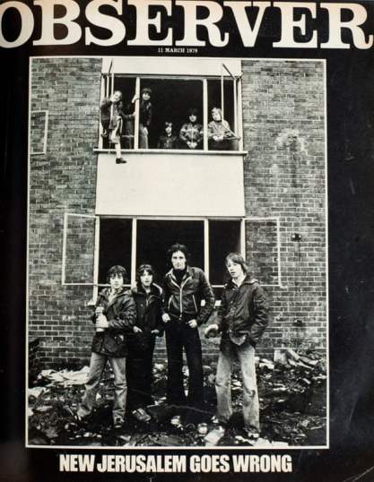
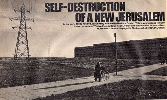
Cover and image from the Observer magazine article on Kirkby in 1979

The forces of law and order were less sympathetic. Chief Superintendent Norman Chapple, in charge of local policing, produced a lengthy report entitled ‘Kirkby New Town: an Objective Assessment of Social, Economic and Police Problems’ in 1975 which received national coverage.

Its statistics made for sobering reading: around 700 council homes were badly vandalised annually;  vandalism generally cost the town some £375,000 a year, a figure comparable, it was said, to a town ten times its size; 14,000 streetlights had been destroyed in a six-month period; an average of five telephone kiosks were vandalised daily. In all, Kirkby’s crime rate was 16 percent higher than the Knowsley and Merseyside average, itself said to be the highest in Britain, and the proportion of juvenile offenders arrested was two-thirds greater than in London. (7)

Kirkby Town Centre

Kirkby town centre, June 1993 © John Wakefield

Chapple acknowledged the context: dissatisfaction with housing, high unemployment, an exceptionally high population of young people and a continuingly high birth rate.  And he recognised the depressing nature of the local environment:

The whole atmosphere of the town centre and the four community centre shopping precincts is marred by the fact that most shops have either bricked up their windows or covered them with permanent and unsightly metal grilles.

But he was also unsparing in his character assessment of the town’s population. He suggested that the parents of Kirkby ‘must accept a large part of the blame for the misconduct of the younger generation and hence their own squalid environment’. He observed a ‘high proportion of irresponsible or manifestly anti-social residents’. And he believed:

All endeavours to improve the general quality of life will be vain, however, unless some way can be found to improve the basically apathetic, irresponsible and anti-social attitude exhibited by a large proportion of the community.

Of course, many residents found such judgments shocking and offensive. Earlier letters to the Liverpool Echo had rejected such stigmatisation: ‘Someone tell me just where you think Kirkby people originate. We are not a separate race’, said Mrs Badcock. Joseph and Margaret McCann complained about Kirkby’s ‘undeserved bad reputation’. One ‘Contented Kirkbyite’ noted the ‘very nice respectable people and families who are a credit to Kirby’. Vandalism, most respondents commented, was not specific to Kirkby but a problem everywhere and in places with far fewer young people. (8)

James Holt Avenue, Westvale sn

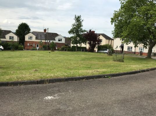
James Holt Avenue, Westvale, 2016

Critical commentary easily lurched into ugly stereotyping and the latter, whatever the reality, merely added to Kirkby’s problems. From somewhere removed in time and place, it’s hard – and perhaps unnecessary – to pass judgement. The seventies seem – this an admittedly anecdotal observation from someone who lived through them – a time of cultural shift; a more troubled and less deferential era. The objective circumstances of Kirkby – poor housing in too many cases, inadequate amenities – warranted grievance. Unemployment, youth unemployment reaching 60 percent, decimated its community; the town’s population fell by 15 percent in the decade after 1971.

And there was, as Chapple noted, though unsympathetically in his case, an anti-authoritarian attitude perhaps rooted in the decades-long experience of a casualised Liverpool docks workforce of ruthless exploitation. Chapple was shocked by the apparently widespread acceptance of the theft and receiving (in police parlance) of stolen goods but ‘nicking’ – as has been noted in Glasgow too – could be viewed as a form of justifiable wealth redistribution by those at the sharp end of social inequality.

The problems and the spotlight – more empathetically in this case – remained on Kirkby in the early 1980s when the Centre for Environmental Studies (CES) researched ‘outer estates in Britain’. Its report on Kirkby and Stockbridge Village (formerly Cantril Farm) – another peripheral Liverpool development – was published in 1985 and noted the ‘chronic state of disrepair’ of much of the housing and the dependence of around half Kirkby’s households on state benefits. The industrial estate’s ‘large-plant, branch-plant economy, making consumer products’ was no longer viable as globalisation impacted and the town’s unemployment rate was 50 percent higher than that of Liverpool as a whole. (9)

St Chad's Health Centre SN

The new St Chad’s Health Centre

All Saints School SN

All Saints Catholic High School, opened in 2010

All this is past history and there has been significant change since. The town was ripe for the area-based regeneration initiatives that characterised government policy from the 1980s onward. Demolition and rebuild in Tower Hill were supported by a £26 million grant from the Estate Action Programme launched in 1985. By 1992, one enthusiastic report claimed the area now had a five-year waiting list of people wanting to move in. Kirkby also received money from the Single Regeneration Budget but the Council’s 1992 bid for City Challenge funding was rejected. (10)

Contrary to received wisdom, New Labour did invest quite heavily in what became known as the ‘left-behind areas’. In Kirkby the results can be seen in new schools and health centres. But secure and decently remunerated employment, given the government’s embrace of a competitive, globalised economy, was a tougher nut to crack.

As was typical, however, the regeneration strategy focused heavily on housing, clearing those areas judged particularly problematic or unpopular. The practical reality of empty and hard-to-let social rent homes in Kirkby and a declining population (from almost 60,000 in 1971 to 40,472 in 2001) made the contemporary policy preference for low-rise mixed-tenure, ‘mixed community’ development an inevitable and, in this case perhaps, justifiable, choice.

Willow Rise foreground and Beech Rise, Northwood SN

Willow Rise (in foreground) and Beech Rise, Parklands, Roughwood Drive, 2016

In 2000, land north of Shevington’s Lane was set aside for ‘a private housing area comparable in size to the original public housing estate’. By 2005, six of the eight 15-storey towers along Roughwood Drive been demolished. Redeveloped by LPC Living and rebranded Parklands, the two remaining towers were refurbished to provide ‘high-quality contemporary accommodation’ for sale whilst ‘40 new two- and three-bedroom mews-style townhouses’ replaced the others. (11)

Sycamore Drive off Roughwood Drive nr Willow Rise SN

New housing at Sycamore Drive off Roughwood Drive, 2016

In Southdene, the two eleven-storey Cherryfield Heights blocks have also been demolished. The surviving four eleven-storey blocks at Gaywood Green are now scheduled for demolition due to fire safety concerns. (12)

The almost unavoidable corollary of regeneration was so-called Large-scale Voluntary Transfer of housing stock from local authorities to housing associations – hardly voluntary as councils were denied the support needed to fund renovations and new build themselves. In 2002, Knowsley Council’s 17,000 homes were transferred to the Knowsley Housing Trust formed for the purpose.  The Council estimated this would release £270 million of new investment in housing.

Quarry Green Heights, Northwood SN II

Quarry Green Heights, 2016

A tower block fire in Huyton in 1991 (before transfer) was seen as ‘a warning which ultimately went unheeded’ and fire risk assessments issued by the Merseyside Fire and Rescue Service in 2017 relating to the Quarry Green blocks reflected what critics saw as a generally bureaucratic and non-responsive attitude amongst a rapidly changing senior staff. The Trust was issued a non-compliance order by the Social Housing Regulator in 2018 which stated baldly that it failed to meet governance requirements. Since April 2020 it has been re-invented as the Livv Housing Group. (13)

Kirkby Shopping Centre SN II

Kirkby shopping centre, 2016

Currently, the twenty-year saga of the regeneration of Kirkby’s town centre is centre-stage with – to cut a long story short – the hopeful news that a Morrison’s superstore, a Home Bargains outlet and a drive-thru (sic) KFC will be gracing the redeveloped centre following a ground-breaking ceremony in January this year. (14)

The current moment (I write in the midst of the Coronavirus pandemic) is hardly propitious to such efforts and the practical and psychological boost of a revived central shopping area will battle unequally against the objective reality of Kirkby’s continuing poverty.  In the modern jargon of multiple deprivation, as of 2018 some 34 percent of Kirkby’s population suffered income deprivation (against an English average of 15 percent) and 28 percent employment deprivation (12 percent). (15)

Brackenhurst Green, Northwood SN

New private housing in Brackenhurst Green, Northwood, 2016

Despite the high hopes – and a degree of hyperbole – which accompanied its inception, Kirkby has not been an unalloyed success though, as ever, many of its residents will have experienced their homes and community far more positively than media headlines and hostile commentary would suggest. Back in 1981, when CES essayed a judgment on what had gone wrong, they concluded that no-one or nothing was directly to blame, except history: ‘the town’s main stumbling block is that “each of the main problems exacerbates the others”’. (16)

That will seem a mealy-mouthed judgement to some. Many would point to planning hubris and, more specifically, the inherent problems associated with large, mono-class peripheral estates. Others would blame poor execution – flawed housing and inadequate amenities. But neither offer sufficient explanation. The necessary context is inequality and a state and society which have in recent decades retreated from the promises of a more classless prosperity that briefly actuated our politics in the era that gave birth to the new town of Kirkby.

Notes

My thanks to John Wakefield for permission to use a couple of his powerful images of Kirkby at this time and for supplying additional detail.

Sources

(1) Quoted in David Kynaston, Modernity Britain: A Shake of the Dice, 1959-62, Book 2 (Bloomsbury Publishing, 2014)

(2) ‘Police See Widening Gap with Public’, The Times, 3 February 1965

(3) Molyneux, ‘Kirkby’s transformation from sleepy rural town to “the great new world”

(4) These working-class struggles are described from a left-wing perspective in numerous accounts. Fisher-Bendix, for example, in libcom.org, Under new management? The Fisher-Bendix occupation and from International Socialism, Malcolm Marks, The Battle at Fisher Bendix; the Tower Hill Rent Strike in Big Flame and the Kirkby Rent Strike and ‘”Empowered working-class housewives” – Big Flame, Women and the Kirkby Rent Strike 1972-73’.

(5) Duncan Sim, ‘Urban Deprivation: Not Just the Inner City’, Area, vol 16, no 4, December 1984

(6) Mark Urbanowicz, Forms of Policing and the Politics of Law Enforcement: A Critical Analysis of Policing in a Merseyside Working Class Community, PhD thesis, University of Warwick, 1985

(7) The quotations which follow are drawn from Ian Craig, ‘Kirkby – “Town in State of Crisis”’, Liverpool Echo, 2 December 1975, Peter Evans, ‘Hooliganism and theft make new town a disaster area’, The Times, 3 December 1975 and Urbanowicz, Forms of Policing and the Politics of Law Enforcement: A Critical Analysis of Policing in a Merseyside Working Class Community.

(8) Letters page, Liverpool Echo, 22 November 1972

(9) CES Paper 27, Outer Estates in Britain: Action Programmes in Kirkby and Stockbridge Village (1985)

(10) ‘The town that fought its way back’, The Times, 13 July 1992

(11) Knowsley Metropolitan Borough Council, Supplementary Planning Document Tower Hill (Kirkby) Action Area (April 2007) and Parklands, LPC Living and ‘Rush to Buy Tower Blocks’, Liverpool Echo, 21 September 2005

(12) See the Tower Block UK website of the University of Edinburgh and Nathaniel Barker, ‘Merseyside housing association to demolish tower blocks after fire safety failings’, Inside Housing, 15 May 2019

(13) Nathaniel Barker, ‘Knowsley Housing Trust: what went wrong?’, Inside Housing 12 October 2018 and Regulator of Social Housing, Regulatory Judgement on Knowsley Housing Trust LH4343, August 2018.

(14) Chloé Vaughan, ‘Ground breaks on retail development in Kirkby’, Place NorthWest, 31 Jan 2020. The town’s Wikipedia entry contains exhaustive detail on the longer story.

(15) Knowsley Council, Kirkby Profile 2018.

(16) Quoted in Sue Woodward, ‘”Town of Apathy”: the Daily Problems of life in Kirkby’, Liverpool Echo, 19 October 1981

Share this:

  • Twitter
  • Facebook
  • Email
  • More
  • Tumblr
  • LinkedIn
  • Reddit
  • Pinterest

Like this:

Like Loading...

The Campsbourne Cottage Estate, Hornsey: ‘a colony of self-contained workmen’s dwellings unsurpassed in the country’

12 Tuesday May 2020

Posted by Municipal Dreams in Guest Post, Haringey, Housing

≈ 5 Comments

Tags

Hornsey, Pre-1914

I’m delighted to feature another guest post today, this by Ray Rogers. Ray is a conservation and historic buildings specialist with a long-standing interest in housing policy and design going back to his early experience of designing council housing in a London borough architects’ department. He is currently writing a series of conservation area appraisals and management plans.

The Campsbourne Cottage Estate in Hornsey, north London, is an early example of council housing built following powers granted to municipal authorities by the Housing of the Working Classes Act 1890. The first part of the Campsbourne estate pre-dates the London County Council’s better-known cottage estates such as Totterdown Fields in Tooting and Tower Gardens in Tottenham.

Nightingale Lane

Nightingale Lane

The design and detailing of the houses and the quality of materials and workmanship give the estate its distinctive character. Apart from some bomb damage sustained in World War Two and some recent alterations to individual houses, the estate remains substantially unchanged in appearance and is exceptionally well preserved. However, it is the story behind the creation of the Campsbourne estate that illustrates the pioneering nature of such developments in responding to the housing issues of their time.

SKM_C45819103009490Early housing legislation such as the Artisans’ and Labourers’ Dwellings Improvement Act of 1875 gave local authorities powers to clear entire areas of ‘insanitary’ buildings but few municipalities (with the exception of major cities such as Glasgow, Liverpool and the London County Council) fulfilled the requirement to replace housing lost through slum clearance, and those that did so mainly relied on philanthropic bodies such as the Peabody Trust to undertake rebuilding.

Most new housing was provided by private speculative builders and in Hornsey as elsewhere these houses were aimed at the emerging lower middle classes. It was the skilled working class that was most directly affected by cyclical slumps in speculative building and the rising cost of housing, and advocates of housing for working people made the case that: (1)

working men of all grades and occupations have been unable to get a decent cottage to live in and have had to choose between occupying part of expensive and overcrowded houses, quite unsuitable for more than one family, or occupying a dilapidated and insanitary dwelling … commonly described as slums.

From the last decade of the 19th century a new type of municipal housing emerged, not just replacing ‘unhealthy’ housing lost through slum clearance but providing a net addition to the housing stock. This was given statutory basis by Part III of the Housing of the Working Classes Act of 1890. The new Urban District Councils, created under the Local Government Act of 1894, were well placed to take advantage of these new powers and Hornsey U.D.C. lost little time in implementing the opportunities offered by the 1890 Act, following its adoption by the authority in 1896.

Corner of Northview Road and Nightingale Lane

Northview Road corner with Nightingale Lane

Hornsey is now part of the London borough of Haringey but until the late 19th century it was a historic settlement straddling both sides of Hornsey High Street. Development of the surrounding open fields proceeded rapidly following the opening of Hornsey station in the late 1860s. Twenty-four acres of land north of the High Street were acquired in 1866 by the British Land Company which laid out an estate of speculative terraced houses that followed the grid iron street pattern and narrow fronted houses typical of ‘by-law’ housing.

Further development was delayed until after 1896 when the Priory estate was sold, of which four and a half acres of land to the west of Nightingale Lane, on the southern boundary of Alexandra Palace, was acquired by Hornsey U.D.C. in 1897. By 1899 the council had built 108 cottages in Nightingale Lane and in Northview and Southview Roads. Another six acres were bought in 1902 and a second scheme of another 140 cottages was started in 1904. (2)

Hornsey is an exceptionally healthy and well-managed urban district in the northern suburbs of London, contrasting very favourably with other urban districts further eastwards. Realising that ‘prevention is better than cure’ the Council and its officers have endeavoured to prevent the growth of new slum areas by themselves establishing a good supply of model cottages for workmen rather than have their district unduly disfigured and deteriorated by the objectionable and overcrowded products of the jerry-builder.

Nightingale Lane early

An early photograph of Nightingale Lane

Both schemes (and a third scheme in Highgate) were overseen by Edwin J Lovegrove, the Borough Engineer and Surveyor, who had designed an earlier cottage development for Richmond Town Council, the ‘Richmond Municipal Cottages’, regarded as one of the first successful cottage developments and described in detail by William Thompson in his Housing Handbook of 1903. Thompson also describes the Hornsey cottages development, then known as the Nightingale Lane scheme, with special attention given to the costs and financing of the project, resulting in a self-financing development with rents considerably lower than those in the private rental market and with no impact on the local rates. On reviewing the Campsbourne schemes in 1905 James Cornes wrote: (3)

No wonder that, with so much knowledge of this subject, he (Lovegrove) has been able … to rear a colony of self-contained workmen’s dwellings unsurpassed in the country. This for London is a revolution in cottage building, and clearly indicates the thought, care, and real ability that the Surveyor must of necessity have put into this work. The Housing Committee and Corporation must be congratulated upon the excellent results of this undertaking, and for the splendid example they have been able to set to other municipalities.

On the east side of Nightingale Lane, the Campsbourne School, opened in 1897, was contemporary with the cottage estate. Designed by Thomas Chatfield Clarke, architect to Hornsey School Board, the school buildings are a good example of a late Queen Anne style Board school.

Northview Road

Northview Road

The first Campsbourne scheme had two classes of houses, Class A having a sitting-room, living room, scullery and three bedrooms and Class B having similar accommodation but smaller and with two bedrooms. The sitting room was in fact the ‘front parlour’ and the living room was the kitchen with scullery attached.

SKM_C45819103009490The second scheme was more ambitious in the range and size of cottages provided. There were four classes of dwelling: Class A had a sitting room, living room, scullery and four bedrooms; Class B the same but with three bedrooms and Class C had two bedrooms. Class D contained a living room, small scullery, bathroom and two bedrooms. The innovation in this scheme was the use of Cornes and Haighton’s combined range, copper and bath in each cottage. The bath could be covered when not in use. The Class A cottage provided for the larger family, as described with typical Edwardian moral condescension by James Cornes in 1905: (3)

… attention should be given to the highest rented cottage in the scheme, providing as it does four bedrooms and a larger sitting room and living room, let to the working man with a wage earning family, thus keeping in a comfortable home grown-up sons and daughters who, too frequently, are turned out into the world and, as a result, contract early and undesirable marriages which might have been avoided had the home surroundings been of a different character.

SKM_C45819103009490

Second scheme – Class A cottage

The completed cottage estate consisted of four streets of two storey houses arranged in short terraces of six to eight houses each. The houses are built in red brick with shallow brick arches over window and door openings. Each of the end of terrace houses are stepped forward slightly and have large projecting gables with barge boards, with two smaller gables within the terrace. The houses have flat street fronts and there are no bays or other projections apart from some porches on the second phase of building.

Northview Road 2

Northview Road

The plain uniformity of the terraces is lightened by the use of simple repetitive detailing in the brickwork. All of the houses have a scalloped brick relief panel set beneath each window cill and a course of dog tooth brickwork set between two projecting brick courses runs along the full length of each terrace.

Southview Road

Southview Road

The houses in Nightingale Lane, Northview Road and Southview Road formed the first phase of development. On these houses the dog-tooth band course runs across each elevation at first floor window cill level. On Nightingale Lane and Northview Road the large chimney stacks also have a dogtooth detail. Northview Road, together with the Nightingale Lane frontage, is the best-preserved of the two streets as Southview Road was affected by bomb damage in World War Two.

Beechwood Road

Beechwood Road

Hawthorn Road and Beechwood Road comprised the second phase of the development and show some changes in form and materials, although still based on terraces each of six or eight houses. The main difference is the use of yellow London stock brick for alternate terraces on both sides of the road, giving the street frontage a more varied and picturesque appearance than in the first phase. The dogtooth band course is retained on the red brick terraces but it runs in a continuous band midway between ground and first floor instead of at window cill level.

Hawthorn Road

Hawthorn Road

On some of the yellow brick terraces the dogtooth detail was replaced with a continuous projecting band of dentilled brickwork in red brick and a similar detail can be seen on some terraces in the LCC’s Tower Gardens estate. The window arches and scalloped relief panel are also all in red brick. Five of the later terraces have paired porches either side of the projecting party wall with a lean-to slate roof and small paned windows.

Hawthorn Road 3

Hawthorn Road

Hawthorn Road 4 Hi Res SN

Hawthorn Road

By 1914 the rest of the land south of Alexandra Palace and to the west of Nightingale Lane had been developed by private builders, completing Northview, Southview, Hawthorn and Beechwood Roads with speculative terraced housing, some using the eclectic pattern book of local architect John Farrer and others in the form of ‘Tyneside’ flats, in which the street frontage has two front doors, one leading to a ground floor flat and the second leading directly to a staircase to a first floor flat.

OS Map

1914 Ordnance Survey map showing the extent of the cottage estate with Alexandra Park to the north

Building in Hornsey stopped in 1914 and after the war councillors could not agree on the need for further council housing in the borough, with many feeling that adequate provision had been made pre-war. The council resisted complying with the Housing and Town Planning Act (the Addison Act) of July 1919, which charged local authorities with building more working-class homes with controlled rents, even though poor housing and insanitary conditions, particularly in the Campsbourne area, had been brought to the attention of its Public Health Committee. An editorial in the Hornsey journal of 7th February 1919 said: (4)

Inasmuch as Hornsey is not altogether what is superficially described as a “working-class” area, it will be seen that the Town Council have not lagged in the provision of workmen’s dwellings. The first of the four schemes was completed in 1898 and the last in 1912. We have reason to believe that the dwellings are almost exclusively occupied by men who actually earn their living in the borough – the local police, the postmen, municipal employees, and others.

The Council can say with the strictest veracity that they have provided for a considerable number of families, but that no further accommodation is needed is not so incontrovertible. Is there no overcrowding in Hornsey? Is there no “unsuitable accommodation”? Are the artisan and the labouring the only classes for whom cheap provision should be made?

Beechwood Road 2

Beechwood Road

Towards the end of 1919 the council eventually gave in to pressure and instructed Edwin Lovegrove to draw up plans for 79 houses to be built on land that had been requisitioned during the war for allotments. However, the housing scheme was never progressed, being dropped on grounds of cost, and the land was bought by the council in 1923 as part of the newly laid out Priory park. This marks the end of a chapter in the pioneering of council house building in Hornsey.

Hawthorn Road 2

Hawthorn Road

The Campsbourne Cottage estate makes no pretensions to great architecture or town planning, being barely touched by the influence of the early Garden City movement, but nevertheless it remains a significant milestone in the provision of affordable housing for working class families and when compared to the housing typical of the time this was no mean achievement. (3)

… Within a few miles of the heart of London he (E J Lovegrove) has succeeded in building a self-contained cottage with a forecourt, garden at the rear and four rooms including a bath and every other modern convenience, to let at 6s. 6d. per week inclusive rental.

The houses are still much valued today. The estate was designated as a conservation area in 1994. A conservation area appraisal and management plan has recently been prepared and it is hoped this will assist the planning authority in controlling some of the piecemeal changes being wrought by ‘home improvements’ that are beginning to detract from the unified appearance of the estate.

Notes

If you’re interested in learning more of Hornsey’s local history, do visit the website of the Hornsey Historical Society.

Sources

(1) William Thompson, quoted in The Lowestoft Journal, 25 February 1899

(2) William Thompson, The Housing Handbook (1903)

(3) James Cornes, Modern Housing in Town and Country (1905)

(4) Janet Owen, Hornsey’s Post-War Housing Problem, Hornsey Historical Society

Share this:

  • Twitter
  • Facebook
  • Email
  • More
  • Tumblr
  • LinkedIn
  • Reddit
  • Pinterest

Like this:

Like Loading...

The Dursley Housing Scheme, 1912, Part II: ‘No Better Housing Scheme’

25 Tuesday Jun 2019

Posted by Municipal Dreams in Gloucestershire, Guest Post, Housing, Rural council housing

≈ 2 Comments

Tags

Dursley, Pre-1914

I’m very pleased to host this second post by Chas Townley, a follow-up to his article last week which looked at the background to Dursley’s pre-war housing scheme. Chas is a Labour District Councillor on Stroud District Council, a ‘no overall control; authority in Gloucestershire. He is currently chair of the Housing Committee. Chas has formerly worked in housing for both councils and housing associations and previously managed the Supporting People Programme in a unitary council. He is a member of the Chartered Institute of Housing.  He is a local historian and genealogist and has written on a variety of subjects including Chartism, Cooperatives, land clubs and building societies, and the Poor Law and pre-NHS health provision.

Returning to Dursley and our 38 first houses, the decision to investigate providing housing started in January 1912 as a result of a circular letter from the Government which offered meetings with officials to assist the council. They also had information from Cirencester Urban District Council, which was already seeking to build houses with rents of 4 shillings a week. Dursley Rural District Council (RDC) members considered this to be far too much rent for ‘the workmen they were concerned about in the area’ – as the rents of those to be evicted from their closed hovels had very low rents. (1)

SN Dursley 5

The plaque marking the opening of the new scheme in Lower Poole Road

Despite such early negativity discussions proceeded and a news report of the Dursley Annual Parish Meeting addressed by Mr Sidney Bloodworth, Chairman of the Dursley Parochial Committee (DPC) and Vice-Chairman of the RDC presented a narrative on why they were looking to build council housing.

It is worth explaining the membership of the DPC which was a Dursley RDC committee consisting of all parish councillors and any RDC members representing the Parish of Dursley. I have come across this form of committee in several researches and it appears to have been a normal method of delegating purely local matters for action. Sadly, as they appear to have operated on an ad hoc basis their records have rarely made it into the official archives. In this case my account is based on occasional newspaper reports.

Bloodworth reports the dilemma that the RDC faced following the Housing and Planning act which ‘demanded the closing of houses which were declared unfit for human habitation’ and that the District Council ‘wanted to be assured that there was somewhere else for them to go’. It is stated that the condemned houses were let at a shilling or 1 shilling and 6d per week (5p to 7.5p). It was admitted that it was impossible to build at anything like that rental ‘without being a burden on the rates’.

They had approached the owner of a site on the Uley Road and ended up conducting discussions with Mr Vizard through his drawing room window overlooking the site with him posing the question pointing at the land ‘Now, if this was your house would you like to sell that field?’ Consequently, he was not prepared to sell at any price. The idea of compulsorily purchasing the site had been gone into but it transpired that compensation would have had to be paid for the devaluation in the house overlooking the site.  Another site was now under consideration and it was hoped to reach agreement with the two owners but it would be necessary to remove a rubbish tip.

Ashton Lister

Sir Ashton Lister, Managing Director of R A Lister & Co and later Liberal MP for Stroud, 1918-1922

An argument against funding the housing was advanced suggesting that the ‘firm that imported the labour which overcrowded the town should provide the dwellings and the Parochial Committee should ask them.’ Counter-arguments claimed that workers should not have to live in houses provided by their employer.

Later in the debate Sir Ashton Lister spoke on behalf of the engineering firm stating they were not the only employer in the town and that ‘if the town did not think the building would be in the interest of the town, then they should not endorse the scheme’. In the discussion he commented that the firm had erected 64 houses and bought 20. Lister also believed there was a need for a further 50 houses in the town.

SN Dursley

Houses in the completed scheme on Upper Poole Road

Despite the passion and heat of the debate the meeting was brought to a close with a unanimous decision to request the DPC to prepare a scheme. (2)

By July an Inspector from the Local Government Board visited the town and was accompanied by a large group of local councillors and inspected some housing sites, the preferred site in two separate ownerships of a Mrs Poole and Bristol Corporation – hence the scheme being in Upper Poole Road.

Modern map Dursley from Know Your place mapping subject to OS copyright sites highlighted

This contemporary map shows the two sites eventually chosen for the scheme.

Agreement had been reached with Mrs Poole but Bristol Corporation were reported to want a ‘ridiculously high value’ on their land. The inspector was shown a variety of other sites including the garden of the workhouse. The report concludes by noting ‘the opinion of the Inspector was that there were two possible sites to choose from’ which are understood to be the Upper Poole Road site and the land they could not purchase at any price. (3)

It now transpired from an enquiry from a member of the House of Lords that the compulsory purchase powers could not be used to obtain the land from Bristol Corporation and John Burns had written that the Rural District Council had been advised to consider a smaller scheme or a slightly different site. (4)

SN Dursley 7

Lower Poole Road

Later than month, a press report referring to the DPC as the Dursley Housing Committee noted that they wanted to persevere with the Poole Cottages scheme and would enter further negotiations with Bristol Corporation. It is suspected that these were fruitless and the scheme was designed to fit the land available, but ironically four or five years later Bristol flogged off the whole of their Dursley land holdings by auction. (5)

It was reported in November 1912 that 150 architects had applied for particulars of the design competition. The rent was not to exceed 4 shillings and 6d (22.5p) and the accommodation was specified as being one living room, three bedrooms, kitchen, scullery with bath and also larder, etc. (6)

SN Dursley 4

Upper Poole Road

Later in the month Arthur Probyn, a 46 year-old architect and surveyor from Gloucester, was announced as the winner. It transpired later that his was one of 40 designs submitted. (7)  From newspaper reports, Probyn undertook works for various organisations mainly in Gloucester including the Gloucester Cooperative Society, the Gloucester Royal Infirmary (at their original Southgate Street premises) and he was one of seven architects engaged on the Tuffley housing scheme in 1920. He was also architect for a school hall for Dursley Tabernacle completed in 1914 and perhaps this scheme meant he was a known quantity. (8)

When it came to the official Board of Health loan sanction inquiry held in March 1913 before the same Inspector who had considered the appropriateness of the site chosen there were no formal objectors. However, Mr Loxton, a member of the Rural District Council who had provided critical challenge to the project, explained some of the deficiencies that had been considered to exist in the scheme including whether the site was sufficient for the number of houses and whether the scheme could be built within the estimated costs.

SN Dursley 6

Upper Poole Road

When the tenders came in in August 1913, all of the tenders exceeded the original estimates. As is often the case, the cheapest from S Williams & Sons of Bristol at £7030 did not represent good value as it excluded the cost of roads and drains. W J B Halls Gloucester £8050 was the next lowest with the highest of seven including being nearly £10,000. One bid had been from Lister & Co, suggesting they had their own building team. It is interesting to note that the actual tender costs all appeared in the newspaper, transparency indeed! Even with Halls’ tender the consequence was to increase both the loan for the scheme and the proposed rent from 4s 6d to as high as 6 shillings.

Given the high level of democracy attached to the scheme, a parish meeting was held to ascertain the views of ratepayers and this is reported at length in the Gloucester Journal. Much of the debate focused on the rental costs with, for example, Arthur Shand arguing that the ‘rent was too high for the working man of Dursley’ and Mr A S Adams suggesting ‘the council would be catering for an entirely different class of people to that which was originally intended’. There were some voices that the Council should abandon the scheme.

SN Dursley 3

Upper Poole Road

The result was that the DPC was asked to go away and find a way to build the houses for rents of 4s 6d, which was way off the original concern felt by Council members back in January 1912 – perhaps showing that the council by inclusion had taken the community with them. It is notable that, despite the contentious nature of the meeting, it was unanimous in thanking DPC ‘for their labours on behalf of the working men of the town’. (9)

In the face of community protest, which wanted low rents, local industrialist Sir Ashton Lister, owner of an expanding engineering factory and later a Liberal MP, dipped his hand in his pocket and gave £500 on condition rents were 5 shillings a week. (10)  Was this an act of ‘charity’ that his Party in Parliament condemned or enlightened self-interest – perhaps the latter as he had already supported the provision of housing by his company.  Consequently, when the matter came before the fortnightly meeting of the District Council, it was agreed to make application for an increased loan of £7852 to enable the housing scheme to be built. (11)

The contract which was let to Halls of Gloucester provided for the first block of four houses to be completed by 31 January 1914 and then two houses to be handed over every two weeks until the scheme was completed. An attempt was made to invite John Burns MP, President of the Local Government Board, to inaugurate the housing scheme but he advised the Council he was unable to attend. (12)

SN Dursley 6

Upper Poole Road

If you do your maths that means the last two were due to be handed over on 26 September 1914 but completion of the scheme wasn’t reported until January 1915, suggesting that there were some delay in completing the scheme. The newspaper columnist was able to report, ‘It has been stated on good authority that no better housing scheme has been formulated under the Housing and Planning Act anywhere in the country.’ (13)

To be frank, as the 38 houses had been shoehorned into the available land with 28 on one site between Upper Poole Road and Lower Poole Road and the remaining ten a short distance further up Upper Poole Road, it was not an adventurous design. It does not have the smart landscaping of later developments like the Circle in Uplands Stroud but this collection of eight terraces of four houses along with three pairs of semis, all built in very solid red brick, was a well-designed scheme with large windows to provide plenty of light.

SN Stroud

An early post-war scheme, built in the 1920s. The Circle, Uplands Stroud. The Gloucestershire and England cricketer Jack Russell learned to play the game on the green.

As such it is perhaps a story of opportunity and chance that Dursley was one of a handful of Districts in Gloucestershire to have built council housing before the war. In fairness, the actual numbers built were pretty small but it is important to recognise the widespread way in which councils of all complexions had started to develop the aspiration that they could respond to local needs by increasing the supply of homes for the working class.

I’m not such a curmudgeon that I don’t think we shouldn’t celebrate Lloyd George’s Homes Fit for Heroes or the sea change achieved by Addison’s 1919 Act. But we also need to celebrate the heavy lifting of John Burns and the pre-war campaigners that created the environment in which building local democratically-controlled council housing was accepted as the obvious policy choice for a post-war Government to encourage.

Chas Townley (chas.h.townley@gmail.com)

Sources

(1) Gloucestershire Chronicle, 6 January 1912

(2) ‘The Housing Question in Dursley’, Gloucester Journal, 16 March 1912, p3 

(3) ‘Dursley: The Housing Question’, Gloucester Citizen, 24 July 1912, p3 

(4) ‘Dursley Housing Scheme Local Government Board’s Suggestion’, Gloucester Citizen, 8 August 1912,  p5  

(5) ‘Dursley: Dursley District Council’, Gloucestershire Chronicle, 31 August 1912′  p2 

(6) ‘General News: Dursley Housing Scheme’, Gloucestershire Echo, 5 November 1912, p3 

(7) Gloucester Journal, 1 February 1913,  p11

(8) ‘Gloucester’s New Houses: Some Rapidly Nearing Completion’, Gloucestershire Chronicle, 4 September 1920, p6. Also Cheltenham Chronicle, 8 July 1914

(9) ‘Dursley Housing Scheme Parishioners Disapprove’, Gloucester Journal, 23 August 1913, p11 

(10) ‘Timely Gift of Sir A Lister Dursley Housing Scheme Rescued’, Cheltenham Chronicle, 6 September 1913, p7 

(11)’Dursley Guardians and District Council’, Gloucester Journal, 6 September 1913, p11 and also ‘Sir A Lister and Dursley Housing’, Evesham Standard & West Midland Observer, 27 September 1913, p6 

(12) Gloucester Journal, 21 February 1914, p10

(13) Berkeley Vale Gleanings: Dursley Housing Scheme’, Cheltenham Chronicle, 9 January 1915, p3  

Share this:

  • Twitter
  • Facebook
  • Email
  • More
  • Tumblr
  • LinkedIn
  • Reddit
  • Pinterest

Like this:

Like Loading...

Orchard Park, Hull, Part II: ‘It’s never had it better than now’

31 Tuesday Jul 2018

Posted by Municipal Dreams in Housing, Hull, Yorkshire

≈ 2 Comments

Tags

1980s, 1990s, 2000s, Regeneration, Yorkshire

We left Orchard Park in Hull in last week’s post in a bad way, in some ways a typical peripheral estate with what by now seemed the usual problems but in other respects an example writ large in terms of its poor quality design and level of social disadvantage.  A further element was introduced by what appeared to be rising problems of criminality and antisocial behaviour.  In this week’s post, we’ll examine the ongoing attempts to revive and improve such increasingly stigmatised estates for which Orchard Park was a significant test-bed.

Barker urbed 5

Orchard Park © Charlie Baker and used with permission

It certainly qualified as a hard-to-let estate, a phenomenon identified by the Labour government of James Callaghan in 1978 and then targeted in the Priority Estates Programme (PEP) inherited by the Conservative government which succeeded.  Its emphasis was on modelling systems of local management and repair and promoting tenant participation.  A growing assumption was also that particular housing forms encouraged crime.

A retrospective Home Office study of three PEP estates (two in Tower Hamlets, London, and the other the Orchard Park Estate) concluded that while all ‘had high crime rates and adverse design’, Orchard Park ‘had a greater level of disorderliness, associated with youth in particular, which fostered a greater sense of insecurity amongst residents, particularly women’. (1)

Barker urbed 6

A worthy entrant for the gardening competition? © Charlie Baker and used with permission

All this played into the mix of changes carried out in Orchard Park in PEP-related activity from 1986 to 1992.  A local estate office was established to deal with repairs, caretaking and lettings. Neighbourhood Management Committees were set up in 1989; various security and environmental initiatives ensued.  A Gardening Competition for residents inaugurated in 1993 takes us back to the domestic respectability promoted by similar such competitions in the cottage suburbs since the 1920s. (2)

There was also some attempt to use the lettings policies in supporting established residents and engineering a more socially beneficial mix of new tenants. The Home Office report captures the contradictions and limitations of such a policy in the face of the intractable realities governing council housing allocations in a period of growing shortage and increased hardship.

Lingcourt SN

Lingcourt, Orchard Park

The report concluded that ‘Territoriality, social cohesion and “empowerment” increased among the residents of the houses’.  Among new tenants, the single mothers, generally provided houses (rather than flats), seem to have complemented the more established residents living disproportionately in the estate’s low-rise homes and contributed to their relative low turnover and ‘respectability’.

At the same time, the combination of a declining economy, homelessness legislation and the shortage of council housing stock ensured that:

a greater number of young poor people and those discharged from institutional care were coming on to the estates. Their arrival at a time of high unemployment and into conditions of poverty created a destabilising influence, swelled the numbers of vulnerable tenants and encouraged more disorderly activities and lifestyles.

These new tenants were housed disproportionately in high-rise flats and:

Despite a programme of improvement to the security of the tower blocks, and better management of the estate as a whole, the newcomers – that is the young, childless poor – displaced many of the previous, elderly residents and attracted crime to themselves, both as perpetrators and victims, concentrating crime in their part of the estate.

It’s all a reminder that council estates are disproportionately required to bear the burden of social and economic problems beyond their purview or, as I would argue, that estates are a victim of societal failings but not their cause.

Barker urbed 9

Orchard Park © Charlie Baker and used with permission

The Home Office report (found, appropriately, on the National Police College website) focused on crime prevention and the various attempts to ‘design out’ crime.  It epitomised a critique and prescription for troubled council estates which became mainstream from the mid-eighties, aimed at, in its words:

1. Creating better dwelling security and more ‘defensible space’

2. Halting a spiral of deterioration … [by] reducing ‘signs of disorder’ and fear of crime

3. Investing in the estate so that resident’s will develop a positive view and thus a greater stake in their community …

4. Increasing informal community control over crime both through increased surveillance and supervision by residents and housing officials and facilitating the development of a set of norms and expectations against offending on the estate.

That’s a pretty good summary of the ‘design disadvantagement’, ‘defensible space’ theories that were popularised in the UK (and simplified) by Alice Coleman in the mid-1980s though, in Orchard Park (its high-rise blocks notwithstanding), it was applied not to modernist, multi-storey housing but to a generally low-rise estate.

Knightscourt,_Orchard_Park_Estate_(geograph_2962567)

Knightscourt © Ian S and made available through a Creative Commons licence

Another, perhaps not altogether disinterested, account celebrates the design modifications implemented across the estate. (3)

Monotonous, unkept [sic] pathways in front of terraced houses were transformed by creating fenced off private yards for each household. A programme of colourful redecoration to external areas did much to brighten the estate’s formerly drab façade.

And ‘attractive tiled canopies were erected around the entrances’ of the three Mildane high-rise blocks, ‘creating a pleasing appearance, as well as giving protection from falling objects’.

At the same time, entryphone systems were installed and CCTV within lifts and ground floor communal areas, the latter at the time apparently accessible to view by tenants on a dedicated TV channel through a communal aerial, bringing a whole new level to our obsession with crime drama on the box.

The article concludes that offences committed by non-residents ‘virtually ceased’ and that the ‘few cases of theft and vandalism’ that persisted were attributable to ‘a minority of residents’.  The changes clearly represented an improvement and there’s no need to sneer at sensible crime reduction initiatives which reduced its prevalence and meaningful environmental improvements even if the overall argument seems a little overstated.   Generally, things were looking up; the chair of the Danes Management Committee concluded ‘The estate is a cleaner, happier place. Repairs are done quickly, the local office is run efficiently.’ (4)

Nevertheless, Orchard Park remained a ‘problem estate’ into the 2000s even as, of course, it continued to provide a decent home to most of its residents.   Of those homes, Right to Buy having wrought its changes even in this apparently unpromising terrain, only around 68 percent were social rented by 2011 with now nine percent let by private landlords.

Barker urbed 10 Feldane

‘Tinned up’ homes in Feldane Orchard Park © Charlie Baker and used with permission

It remained an unpopular estate to outsiders; when some choice existed between 2001 and 2003, the vacancy rate stood at 26 percent and the average re-letting period at 322 days, three times worse than any other Hull estate. Fifty-two percent of OP residents were satisfied with their neighbourhood against an average of 72 percent city-wide. (5)

Ribycourt SN

Ribycourt

When the urban design consultancy Urbed worked with Gateway Pathfinder to create (in their words) ‘an engagement and capacity building programme for tenants and residents’ in Orchard Park, the vision of some seemed modest at first glance though the attitudinal shift they wanted might have been life-changing for some: (6)

My vision for Orchard Park is that it comes in line with all the other communities in Hull and it’s not singled out, when my son is eighteen and goes for a job he isn’t discriminated against because his postcode is HU6.

The veteran local Labour councillor Terry Geraghty articulated a similar ambition:

We need to get away from the idea of Orchard Park being on its own; we are all one community and we need to break down those barriers. The image the area has is not deserved, 90% of the people that live here are incredibly hard working people and we need to get the information to those in business that just because someone lives in Orchard Park it doesn’t mean they are any less capable of doing the jobs that everyone else in Hull can do …

At the time, unemployment among the economically active was at 27 percent on the estate, compared to 12 percent in Hull as a whole and six percent nationally.  The Estate was among the five percent most deprived in the country; the Danes, tainted by its original design and construction flaws, was in the worst one percent. Meanwhile, for all the previously lauded design modifications, the Estate suffered the highest crime rate in Hull. (7)

Martin Crookston, an advocate for the cottage suburbs and their revival, concluded uncharacteristically that:

Orchard Park, created at the tail-end of the long years of estate-building, and at the outer edge of its city as that city started to run out of economic steam, was probably always an estate ‘too far’ – at the problem rather than potential end of the corporation suburb spectrum.

He counselled ‘radical change’.

Barker urbed 4

High-rise and clearance © Charlie Baker and used with permission

In many ways, the Council has acted on that advice.   The first three of the high-rise blocks to be demolished went in 2002, including ironically two of the Mildane blocks improved by those ‘attractive tiled canopies’ back in the eighties.  The twenty-two storey Vernon House in Homethorpe was demolished in 2004.  In 2008, the council began planning the clearance of the remaining seven.

This obvious, apparently radical change wasn’t universally welcomed.  With little in the first instance to replace them, one local resident feared it as a sign of ‘managed decline’.  An elderly resident of one of the tower blocks, confounding stereotypes, lamented their loss: (8)

I like the flats as they are, I don’t want them changed at all. I leave my door open most of the day but I lock it at teatime … We’ve got beautiful views, you must admit, you get away from everybody, you don’t answer the door if you don’t want to. I would miss my view, I would never go and live in a house and look across at somebody’s back yard.

She suggested they reserve her block for those aged over 55, a solution to tower block living adopted in two of the estate’s towers.

Highcourt demolition

Highcourt demolition, March 2015 © Keith Jackson

Despite initial stays of execution for Gorthorpe and Kinthorpe blocks in 2012 (such was the housing shortage), demolitions continued.  Twenty-storey Highcourt, was demolished in March 2015. Residents’ comments capture the mixed feelings of the event: (9)

I was a young girl living in north Hull when this block of flats was built. I remember the new building being celebrated because there was a houses shortage at the time but now it’s demolition is being celebrated.

For another, it was an eyesore but he’d miss it on his morning walk.  The last of Orchard Park’s high-rise blocks went with the demolition of the Gorthorpe flats in 2016.

Meanwhile, Orchard Park and Hull more widely was subject to the initiatives governing housing policy and finance nationally.  The Housing Market Renewal or Pathfinder programme laudably aimed to ‘provide lasting solutions for communities blighted by derelict homes through investment and innovation’; its chosen means – which seemed to focus on the demolition of sometimes decent housing and market-led solutions – were far more controversial.

The Hull and East Riding Housing Market Renewal Pathfinder (or Hull Gateway) was established in 2005 but plans to tackle the Thorpes in Orchard Park came to nought and the initiative as a whole was defunded in 2010. (10)

PFI cover

The cover of Hull’s PFI document, August 2010

The Council also entertained hopes that the Private Finance Initiative (PFI), introduced by John Major but significantly expanded under New Labour, might enable the sweeping changes many nevertheless thought necessary.  The title of the 2008 bid document, The Transformation of Orchard Park – Shaping the Place, Creating a Fruitful Future, captures those hopes; its 16 sections and 29 appendices reflect their breadth; and the price tag – at £142m – suggests the extent of the work deemed necessary. (11)

In summary, the proposals envisaged the demolition of 752 council houses, 255 privately owned houses, and 33 council bungalows and their replacement with 1020 new homes in the private sector and 680 new homes for social renting. This was a net gain of 660 homes but the figure conceals a net loss of 105 social rented homes.

Courtpark Road SN

Courtpark Road

It’s worth pausing – amidst the money talk and statistics – to examine what’s going on here and how powerfully it symbolises the policies and presumptions of the era.  Firstly, we have the dependence on private capital – the minimisation of state investment reflecting both a callow political fear of public spending (better understood as investment) and an unquestioning belief in the efficiency and ultimate beneficence of the market.

Secondly, perhaps less controversially still, there is the belief in so-called mixed communities (ignoring the fact that estates already accommodate a mixed community) and mixed tenure.  It marks a moment when council estates as such were deemed to have failed socially and economically.  For all the specific design shortcomings of Orchard Park, we might think it the victim of social and economic failure rather than its agent.  And we should certainly question why all these contemporary ‘fixes’ to long-term housing problems seemingly require the loss of desperately needed social rented homes.

The Orchard Park PFI was awarded £156m in July 2009.  In one of the first substantive acts of the new Conservative-Liberal Democrat coalition government, all new PFI schemes (including Orchard Park) were cancelled in November 2010.  Given the huge and ongoing expense of the PFI programme and its complexity and troubled implementation, that might seem a relief but it left Hull still scrabbling for finance and dependent on partnerships with private developers or housing associations which could access capital.

Homethorpe1234JPG

New homes being built in Homethorpe © Humberbusiness.com

Nevertheless, some of that has borne fruit in the construction of new homes in the Danepark area and a recently completed scheme in association with Wates and the Riverside Group housing association at Homethorpe creating 52 new homes for rent including 16 one-bed council flats. A major refurbishment programme providing external cladding to the 1668 ‘No Fines’ homes in Orchard Park began in 2016.  The Harrison Park extra care apartments for those who need to assisted living are some of the finest in the country.

TheOrchardCentre_Hull1

The Orchard Centre

The £14m Orchard Centre (a local council hub and health centre) opened on the southern fringe of the estate in 2009. A new community park and multi-use games area has opened.  Remodelling of the run-down shopping centre has made that a more attractive space.

How to conclude? What to conclude?  If you want an illustration of the power of selective narratives, let’s look at two recent press reports.   A March 2018 report in the local press recounts three recent stabbings and residents’ fears that violence on the estate was ‘getting out of hand’.   A few months earlier, another report had been headlined ‘We’ve lived on Orchard Park for 50 years – and it’s never had it better than now’. Mrs Gray moved with her husband to their terrace house in Cladshaw in 1966 and has lived there ever since: (12)

I know some people have bad things to say about Orchard Park but we have had no trouble and we brought up our children here.

Let’s finish with that – not because Orchard Park has been untroubled or without failings, some of which could have been foreseen and forestalled with greater investment and better design, but because it reminds us it’s been a home to many thousands, usually a good one and, hopefully, an improving one.

Sources

My thanks to Charlie Baker for permission to use images contained in his report for Urbed, Orchard Park (September 2006). You can find more of his evocative photography on his website.

My thanks also to Tim Morton for providing the 1993 PEP report referenced and Keith Jacobs for supplying photographs of the demolition of Highcourt.

(1) Housing, Community and Crime: the Impact of the Priority Estates Project (Home Office Research Study 131, 1993)

(2) ‘Orchard Park, Hull’ (Priority Estates Project, 1993)

(3) Roy Carter, ‘Designing Crime Out of the Urban Environment’, Orchard Park Case Study, Architect and Surveyor, vol 64, no 9, October 1989

(4) ‘Orchard Park, Hull’ (Priority Estates Project, 1993)

(5) Martin Crookston, Garden Suburbs of Tomorrow?  A New Future for the Cottage Estates (2016)

(6) Quoted in Charlie Baker, Urbed, Orchard Park (September 2006)

(7) Crookston, Garden Suburbs of Tomorrow? 

(8) Angus Young, ‘Orchard Park’s Gorthorpe and Kinthorpe tower blocks to be demolished after Hull City Council U-turn’, Hull Daily Mail, May 2, 2014

(9)Quoted in Claire Carter, ‘Gone in Eight Seconds’, Daily Mail, 9 March 2015

(10) The Urban Rim website Gateway Pathfinder provides full details.

(11) The Urban Rim website also provides a full chronological account of the Orchard Park PFI.

(12) Phil Winter, ‘’”Orchard Park violence is getting out of hand”: Fear as estate sees three stabbings in under a month’ Hull Daily Mail, 21 March 2018 and Kevin Shoesmith, ‘We’ve lived on Orchard Park for 50 years – and it’s never had it better than now‘, Hull Daily Mail, 30 September 2017

Share this:

  • Twitter
  • Facebook
  • Email
  • More
  • Tumblr
  • LinkedIn
  • Reddit
  • Pinterest

Like this:

Like Loading...

Open House London 2016: A Tour of the Capital’s Council Housing, Part Two

13 Tuesday Sep 2016

Posted by Municipal Dreams in Housing, London

≈ 2 Comments

Tags

#OpenHouse2016

Part One of our look at council housing featured in Open House London on the weekend of 17-18 September left us in the East End in Bethnal Green where a progressive Labour council had commissioned Denys Lasdun, one of the leading architects of the day, to design high-quality housing for its working people.

Lubetkin

Lubetkin

Moving westwards, we’ll begin this week’s post in another radical Labour stronghold and with the architect who probably brought the greatest political commitment to that task.  Berthold Lubetkin famously declared – in relation to his celebrated design for the Finsbury Health Centre – that ‘nothing [was] too good for ordinary people’.  His Spa Green Estate nearby, completed in 1949 and described by the Survey of London, not prone to hyperbole, as ‘heroic’ and by Nikolaus Pevsner as ‘the most innovative public housing’ of its time, also reflected that ideal.

SN Bevin Court

Bevin Court

Neither of these appear in Open House but two of Lubetkin’s schemes for the Finsbury Metropolitan Borough Council – one of the most progressive in the capital – are featured.  Bevin Court was opened in 1954; the Cold War having put paid to plans to name the building after Lenin (who had once lived on it site).  Its innovative seven-story Y-shape capitalised on its site and ensured none of the flats faced north but, visually, its crowning glory is its central staircase.  Visit to see that and the newly restored Peter Yates murals and bust of Bevin in the entrance lobby.

640px-Bevin_Court_(3318843174) Steve Cadman

Bevin Court, Peter Yates mural (c) Steve Cadman and made available under a Creative Commons licence

SN Priory Green

Priory Green Estate

A few minutes’ walk to the north, you can also visit Lubetkin’s Priory Green Estate, completed three years later.  It’s a much larger estate – 288 homes in seven large blocks but with similar attention paid to lay-out and landscaping and more striking, sculptural staircases.  The Estate was transferred from Islington Borough Council, Finsbury’s successor after 1965, to Peabody in 1999 and, having fallen on hard times, has since been renovated with the aid of a £2m Heritage Lottery grant.

SN Cranbrook Estate

Cranbrook Estate showing the old people’s bungalows and Elizabeth Frink’s ‘Blind Beggar and Dog’ (1957)

Our final example of Lubetkin’s work takes us back to Bethnal Green. The Cranbrook Estate was built between 1955 and 1966.  With 529 homes in total – arranged in a geometric ensemble of six tower and five medium-rise blocks artfully diminishing in scale to the single-storey terrace of old people’s bungalows on the Roman Road – it is one and half times the size of le Corbusier’s Unité d’Habitation.  Lutbetkin’s biographer, John Allen, rightly describes it as a ‘stupendous tour de force’ and only detracts from that compliment by seeming to lament the ‘domestic intricacies of municipal housing’ which lie behind it.  I’ll take those – as Lubetkin would – as, in fact, its crowning achievement.

SN Dawsons Heights

Dawson’s Heights

Dawson’s Heights, in East Dulwich, literally crowns its dramatic hill-top setting, so much so that English Heritage (in a listing proposal rejected by the Secretary of State) was moved to almost lyrical praise of the scheme’s ‘striking and original massing’ and its ‘evocative associations with ancient cities and Italian hill towns’.  The Estate, two large ziggurat-style blocks designed to offer views and sunlight to each of their 296 flats, was built between 1968 and 1972 – an in-house design for Southwark Borough Council by Kate Macintosh then aged just 26.  She’s alive and kicking and still a doughty defender of social housing and its social purpose.

941-F

The World’s End Estate

Another estate which capitalises on its superb setting is the World’s End Estate, completed in 1977, set on the banks of the Thames across London in the Borough of Kensington and Chelsea.  Designed by Eric Lyons and HT (‘Jim’) Cadbury-Brown, in plain terms it comprises seven 18 to 21-storey tower blocks, joined in a figure of eight by nine four-storey walkway blocks but the whole, clad in warm-red brick, possesses a romantic, castellated appearance, providing  great views within and without.

SN Gascoigne

Gascoigne Estate (c) barkingassemblage.wordpress.com

All this might seem a world away from the Gascoigne Estate in Barking, a sprawling 1960s estate with seventeen tower blocks, housing some 4000 people.  It’s been a troubled and unpopular estate in recent years whose design and history might stand as representative of many much-criticised estates built in an era of mass rehousing when scale sometimes outpaced finesse.  For all that, it’s been a home to many and it’s good to see – as a major regeneration scheme takes off – that history of community celebrated in the Open Estate Living Museum that features in this year’s Open House programme.  I’m looking forward to finding out more.

If the Gascoigne Estate – demonised and stereotyped like so many so-called ‘problem estates’ – might be taken by some to represent the worst of a flawed era of public housing, two London boroughs – learning from mistakes made elsewhere – built some of this country’s finest council housing.  The typically high-density but low- to medium-rise developments built after the collapse of the Ronan Point tower block in 1968 represent the best of what public housing might have achieved in the longer-term had it been supported.

Hollamby 1974

Ted Hollamby

As Chief Architect for the new (post-65) Borough of Lambeth, Ted Hollamby had concluded that ‘people do not desperately desire to be housed in large estates, no matter how imaginative the design and convenient the dwellings’.  Hollamby believed that ‘most people like fairly small-scale and visually comprehensible environments.  They call them villages, even when they are manifestly not’.  His vision can be seen enacted in two very fine council estates on show during Open House.


SN Central Hill

Central Hill Estate

Central Hill in Upper Norwood, completed in 1973, is a stepped development designed to make best use of its attractive site but it reflects Lambeth and Hollamby’s signature style in its intimacy and human scale.  It’s worked; it’s a well-loved estate with a strong sense of community. Unfortunately, as part of Lambeth’s commendable pledge to build 1000 new homes at council rent in the borough, it has become another victim of ‘regeneration’; in actual fact, the threat of demolition.

All these council estates – like homes everywhere – require upkeep and maintenance (and too many have fallen prey to poor maintenance over the years) but ‘regeneration’ in this context means the destruction of good homes and the wiping out of existing communities.  One driver of this madness is ‘densification’ – an ugly term to describe the ugly reality that many of our politicians and planners believe working-class homes must be built at greater density.  The other is money or the lack of it – the pressure to sell council real estate and build private housing for sale in order to raise capital for social housing at best or so-called ‘affordable’ housing at worst.

The lunatic logic of this should be plain to all but those with a naïve faith or vested interest in the unfettered market – the very market which failed ordinary people in years past and fails us now.

IMG_0085 (a)

Cressingham Gardens

The plans to wreak this havoc on Cressingham Gardens, one of Lambeth’s finest estates – described in 1981 by Lord Esher, president of RIBA, as ‘warm and informal…one of the nicest small schemes in England’ – have already been approved, its residents still fighting valiantly a rearguard action.  It’s a beautiful estate nestling on the edge of Brockwell Park which manages superbly, in Hollamby’s words again, to ‘create a sense of smallness inside the bigness…and to get the kind of atmosphere in which people did not feel all herded together’.   It’s worth a visit and its residents deserve our support.

Sn Whittington Estate Lulot Gardens (6)

Lulot Gardens, Whittington Estate

Across the capital, another progressive borough, Camden – under the enlightened leadership of Borough Architect Sydney Cook – had also developed its own striking house style.  This can be seen firstly in the Whittington Estate, begun in 1969, designed by Peter Tábori, another young architect then in his mid-twenties.

Sn Whittington Estate Stoneleigh Terrace (2)

Stoneleigh Terrace, Whittington Estate

It’s a larger, grander scheme than those of Lambeth – in signature Camden style, six parallel linear stepped-section blocks of light pre-cast concrete construction and dark-stained timber.  It was designed to be a ‘form of housing…which related more closely to the existing urban fabric than the slab and tower blocks, and which brought more dwellings close to the ground’. Each home had its own front door and a walk through the front door of 8 Stoneleigh Terrace during Open House will allow you to glimpse the innovative interior design of the housing too, chiefly the work of Ken Adie of the Council’s Department of Technical Services.

Sn Dartmouth Park Hill (2)

Dartmouth Park Hill

When you leave take time to visit a later stage of the Highgate New Town scheme along Dartmouth Park Hill, marking a turn away from the estate conception to streetscape and more in keeping with local vernacular form but still housing of the highest order.  Finally, a view of the Chester-Balmore Scheme, built to Passivhaus standards to ensure the highest levels of sustainability, at the corner of Raydon Street and Chester Road opposite the Whittington Estate, will show you the very latest advances in social housing.

Dunboyne Road

Dunboyne Road Estate

Aside from Cook, Camden’s superb council housing of this era is chiefly associated with Neave Brown, the only living architect to have had all his UK work officially listed. This year’s Open House features, the Dunboyne Road (formerly Fleet Road) Estate (no. 36 to be precise), designed by Brown in 1966 and finally completed in 1977.  Its three white, stepped parallel blocks and now mature gardens provide a striking ensemble, noted by English Heritage in their 2010 Grade II listing for its ‘strong modernist aesthetic’ and a ‘simple, bold overall composition’ belying the scheme’s complexity and sophistication.

P1010155

Rowley Way, Alexandra Road Estate

The other Brown scheme in Open House is generally judged one of the most attractive and architecturally accomplished council estates in the country, the Alexandra Road Estate,  listed Grade II* in 1993.  It’s better seen than described but, in its scale and confidence, it marks (in the words of modernist architect John Winter), ‘a magical moment for English housing’.  Make sure to visit the recently renovated Alexandra Road Park and Tenants’ Hall (also featured in Open House), both integral to the design and original conception of the estate.

Alexandra Road was completed in 1979 – the year in which such high ambition would be consigned to the graveyard of history.  It’s a sad irony that some of the very best of our council housing was built just as its near-century long story of practical idealism and shared social purpose was drawing to a close.

i-love-council-houses-south-london-1

I hadn’t intended this tour of some of London’s finest council estates to be so elegiac but the contemporary picture of social housing’s marginalisation and market-driven ‘regeneration’ creates a poignant counterpoint to the energy and aspirations of previous generations.  If you visit any of the estates on show during Open House London, my plea to you is to think of them not as monuments to a bygone era but as beacons of what we can and should achieve in a brighter future.

Note

The residents of Central Hill and Cressingham Gardens both have active campaigns fighting to preserve their homes and communities.  See Save Central Hill and Save Cressingham Gardens to find out more and lend your support.

SHOUT (Social Housing under Threat) has its own website and is actively campaigning to defend social housing and promote it as the best and necessary solution to our housing crisis.

Share this:

  • Twitter
  • Facebook
  • Email
  • More
  • Tumblr
  • LinkedIn
  • Reddit
  • Pinterest

Like this:

Like Loading...

The Council House, Birmingham: ‘a bricks-and-mortar monument to the municipal gospel’

12 Tuesday Feb 2013

Posted by Municipal Dreams in Birmingham, Town Hall

≈ 1 Comment

Tags

Pre-1914

For those of you who have been following my blog, this might come as a bit of a shock: no working-class politics here and, on the face of it, a ‘municipal dream’ almost extravagant in its disregard for the lives of the poorest. But I think this municipal showpiece deserves some love.

‘Municipal reformers look to Birmingham as the eyes of the faithful are turned to Mecca.’(1)  By the late 19th century, Birmingham City Council had a reputation for radicalism unequalled in the country. This reputation owed not a little to the showmanship of the city’s leading politician, Joseph Chamberlain, and the extraordinary rhetoric employed by Chamberlain and other civic leaders. But the belief in municipal enterprise and pride in municipal endeavour were real as were its achievements.

We could write about the city’s early municipalisation of gas and water or its later record of council house building and healthcare. And we will but this entry will celebrate – unfashionably – the town hall or, as it’s known in Birmingham because an earlier building had taken that name, the Council House.

A postcard from the early 1900s

The Council House today

The Council House is designed to impress and does so, though perhaps more through scale and a sort of heavy grandiosity than any great architectural merit. The building emerged from a design competition and the winner, Yeoville Thomason, through a murky process which favoured the local man. The waters were muddied further by the request that Thomason’s final plans include design elements from another entry. This might explain the rather conflicted appearance of the facade – Renaissance palace and heavy classical portico. But the building’s interest lies more in the ideas that inspired it.

Construction began in 1874 with Chamberlain himself laying the foundation stone. He graced the event with sentiments that, though he articulated them with peculiar force and eloquence, were typical of the era:

I have an abiding faith in municipal institutions, an abiding sense of the value and importance of local self-government, and I desire therefore to surround them by everything which can mark their importance, which can show the place they occupy in public estimation and respect and which can point to their great value to the community. Our corporations represent the authority of the people. Through them you obtain the full and direct expression of the popular will, and consequently any disrespect to us, anything which would depreciate us in the public estimation, necessarily degrades the principles which we represent…

It’s a lengthy quote but it repays attention. It eulogises representative government, lauds local sovereignty and enshrines the corporation – the local council – as the highest embodiment of public service and popular democracy. By extension, it justifies high public spending on municipal buildings to signal respect for self-governance and to reflect – and enhance – local patriotism.

George Dawson (1821-1876)

If that seems extravagant, remember that Chamberlain’s early mentor was George Dawson, a nonconformist minister and a man who could talk unashamedly of ‘the new corporation, the new Church’. Dawson’s exalted vision of local government is best captured in the speech he gave at the opening ceremony of a new municipal library:

…a great town exists to discharge towards the people of that town the duties that a great nation exists to discharge towards the people of that nation – that the town is a solemn organism through which should flow, and in which should be shaped all the highest, loftiest and truest ends of man’s intellectual and moral nature.

Such ideas seem almost unthinkable today when politicians are held in almost universal obloquy and even local councillors are often thought to be self-interested egotists. Chamberlain, by contrast, thought there was ‘no nobler sphere for those who have not the opportunity of engaging in imperial politics than to take part in municipal work.’

This was the Civic Gospel – a vision of municipal service in the broadest sense: service from the brightest and the best, service to a citizenry or those who might be raised to citizenry.

The Council House was ‘a bricks-and-mortar memorial’ to this gospel and begins to seem an almost modest embodiment of such ideals.(2) But it was designed also – by force of presence and in detail – to celebrate Birmingham and Birmingham democracy.  By 1879, the date of its completion, the building had cost some £163,000.  At today’s values, that’s a cool £12m or so.  Then, to many, it seemed money well spent.

Among the most striking decorative features of the building is the mosaic (by the Venetian artist, Salviati) above the main entrance . It portrays six figures representing Science, Art, Liberty, Law, Commerce and Industry. Tellingly, they are placed around a central, enthroned figure which represents Municipality.

Above this, within the central pediment, is a set of sculptures entitled Britannia receiving the manufacturers of Birmingham. She does so in friendly fashion, awarding wreaths of laurel. (No harping on about the depredations of industrial capitalism here.)

This does, of course, lead to an alternative reading of the politics of Chamberlain and the Civic Gospel. It was a triumphantly bourgeois politics, reflecting an industrial class and a local elite at the apogee of its power and self-confidence. The term ‘corporation’ hadn’t then acquired its later meaning but there is something apposite in the latter – the council run as a business by those with the status and means to do it.

Birmingham in its industrial heyday. The Council House with museum and art gallery extension are depicted centre. The collonaded Town Hall can be seen centre right and the Chamberlain Memorial erected in 1880 bottom centre.

Chamberlain himself became a Unionist (an opponent of Irish Home Rule) and an imperialist and there wasn’t much local self-government tolerated in either of those. His son Neville Chamberlain – a Birmingham councillor and mayor (‘a good mayor of Birmingham in a lean year’ according to an unfriendly Lloyd George) and a drier, more conventionally right-wing politician – seems even more removed from the reforming vision and ideals of the Civic Gospel.

Neville Chamberlain as mayor of Birmingham, 1915

But Neville founded the country’s only municipal bank and the record of achievement of Birmingham Chamberlainism (the only word that can capture the unique admixture of local politics) was impressive. As one frustrated local Labour politician stated as late as 1930, Birmingham’s ‘civic history [was] an inspiring record of the success and practicality of social ownership even,’ he added, ‘when administered by those who do not believe in it.’

However, if Birmingham’s middle-class reformers rejected socialism or any ideology of public ownership, they embraced business-like municipal enterprise and upheld a powerful vision of both the duty and potential of local government to improve the conditions of the people.

A municipal showpiece such as the Council House might not, on first impression, seem the best embodiment of these progressive ideals. But recall Joseph Chamberlain’s words above on the dignity of municipal institutions and Dawson’s ideal of their majesty. If we can’t, in these more jaded and cynical times, quite bring ourselves to go that far, we can at least remember a time when pride in local government was common and widespread.

Sources:

(1) Frederick Dolman, Municipalities at Work, 1895

(2) Tristram Hunt, Building Jerusalem. The Rise and Fall of the Victorian City, 2004

Asa Briggs has written the classic account but Tristram Hunt is the best recent source on Birmingham’s Municipal Gospel (as he prefers to call it.) Additional information on the architecture of the Council House can be found on the Victorian Web. My thanks to Jacqueline Banerjee of Victorian Web for allowing use of the photographs of the Council House mosaic and sculptures above.

Share this:

  • Twitter
  • Facebook
  • Email
  • More
  • Tumblr
  • LinkedIn
  • Reddit
  • Pinterest

Like this:

Like Loading...

Enter your email address to follow this blog and receive notifications of new posts by email.

Join 16,935 other followers

Archives

  • August 2022
  • July 2022
  • June 2022
  • February 2022
  • December 2021
  • September 2021
  • August 2021
  • May 2021
  • April 2021
  • March 2021
  • February 2021
  • January 2021
  • December 2020
  • November 2020
  • October 2020
  • September 2020
  • August 2020
  • July 2020
  • June 2020
  • May 2020
  • April 2020
  • March 2020
  • February 2020
  • January 2020
  • December 2019
  • November 2019
  • October 2019
  • September 2019
  • August 2019
  • July 2019
  • June 2019
  • April 2019
  • March 2019
  • February 2019
  • January 2019
  • December 2018
  • October 2018
  • September 2018
  • August 2018
  • July 2018
  • June 2018
  • May 2018
  • April 2018
  • March 2018
  • February 2018
  • January 2018
  • December 2017
  • November 2017
  • October 2017
  • September 2017
  • August 2017
  • July 2017
  • June 2017
  • May 2017
  • April 2017
  • March 2017
  • February 2017
  • January 2017
  • December 2016
  • November 2016
  • October 2016
  • September 2016
  • August 2016
  • July 2016
  • June 2016
  • May 2016
  • April 2016
  • March 2016
  • February 2016
  • January 2016
  • December 2015
  • November 2015
  • October 2015
  • September 2015
  • August 2015
  • July 2015
  • June 2015
  • May 2015
  • April 2015
  • March 2015
  • February 2015
  • January 2015
  • December 2014
  • November 2014
  • October 2014
  • September 2014
  • August 2014
  • July 2014
  • June 2014
  • May 2014
  • April 2014
  • March 2014
  • February 2014
  • January 2014
  • December 2013
  • November 2013
  • October 2013
  • September 2013
  • August 2013
  • July 2013
  • June 2013
  • May 2013
  • April 2013
  • March 2013
  • February 2013
  • January 2013

Blogs I Follow

  • Coming Home
  • Magistraal
  • seized by death and prisoners made
  • Women's Work in Rural England, 1500-1700
  • A London Inheritance
  • London's Housing Struggles
  • architectsforsocialhousing
  • The Historic England Blog
  • The GDR Objectified
  • The London Column
  • A Sense of Place
  • distinctly black country
  • Suburban Citizen
  • Mapping Urban Form and Society
  • Red Brick
  • Single Aspect's Blog
  • History & Social Action News and Events
  • The Charnel-House
  • Musings
  • Council Homes Chat

Create a free website or blog at WordPress.com.

Coming Home

Magistraal

seized by death and prisoners made

stories from our past.

Women's Work in Rural England, 1500-1700

Leverhulme Funded Project at University of Exeter: Adopting a New Methodological Approach to Early Modern Women's Work

A London Inheritance

A Private History of a Public City

London's Housing Struggles

acting as a knowledge broker towards London's housing crisis, going on a search for alternatives, get in touch londonshousing@gmail.com

architectsforsocialhousing

Architects for Social Housing (ASH) has been set up to respond architecturally to London’s housing crisis.

The Historic England Blog

The GDR Objectified

A private collection of ephemera from or related to the German Democratic Republic

The London Column

Reports from the life of a city, from 1951 to now, compiled by David Secombe

A Sense of Place

Better Lives in Better Places

distinctly black country

a network for understanding yesterday's landscape today

Suburban Citizen

A fine WordPress.com site

Mapping Urban Form and Society

Red Brick

The place for progressive housing policy debate.

Single Aspect's Blog

because I care about public housing and hate single aspect flats

History & Social Action News and Events

News and events related to history and social action, especially in Battersea, Croydon, Kennington, Vauxhall & Wandsworth

The Charnel-House

From Bauhaus to Beinhaus

Musings

of a social historian

Council Homes Chat

Busting myths about Council Housing by providing a platform for people's stories/experiences #CouncilHomesChat #SocialHousing

Privacy & Cookies: This site uses cookies. By continuing to use this website, you agree to their use.
To find out more, including how to control cookies, see here: Cookie Policy
  • Follow Following
    • Municipal Dreams
    • Join 16,935 other followers
    • Already have a WordPress.com account? Log in now.
    • Municipal Dreams
    • Customize
    • Follow Following
    • Sign up
    • Log in
    • Report this content
    • View site in Reader
    • Manage subscriptions
    • Collapse this bar
 

Loading Comments...
 

    %d bloggers like this: